Geography Research for Hispanic Heritage Month Students

- Grades
- Grades 6–9, High School, Middle School
- File type
- Preparation
- Print ready


- Subject
- Social Studies, Geography
- Topic
- Hispanic Heritage Month, geography research
- Resource types
- Worksheets & Printables, Worksheets
- Preparation
- Print ready
About this resource
What's inside this resource
Hispanic Heritage Month: Geography Research is a resource for students to engage in research about:
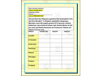
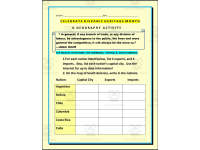
*Countries capital city
*Countries imports and exports
*Hispanic population in the USA
*Geographic location
This Hispanic Heritage Month: Geography Research also includes a table for students to complete through their research. This table includes the capital city, exports, and imports for each of the countries located.
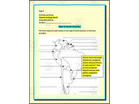
Additionally, this Hispanic Heritage Month: Geography Research includes a page with the map of Latin-American countries for students to write in the names for each nation on the map of South America, on the lines provided.
This Hispanic Heritage Month: Geography Research was designed for students in 6th, 7th, 8th, and/or 9th grades. This resource may be used as a part of a lesson for students to engage and complete the research. Additionally, the resource may be used as an assessment to evaluate how much students have learned about the topic. Students may receive the map first and then the table to complete, or all pages together for students to complete. Teachers need to establish time limits for students to complete this resource.
This Hispanic Heritage Month: Geography Research resource is ready to print and use. A PDF with 4 pages.
Related resources
More resources teachers may find useful
24 related resources were found using this product's title, contributor, categories and tags.
In the classroom
Teaching tips & learning objectives

Learning objectives
- Locate and label South American countries on a map
- Identify capitals and major trade goods of Latin American countries
- Interpret population statistics from census data

Teaching tips
- Students need internet access to research the imports, exports and capitals.

Skills covered
- Research — finding trade and capital data for each country
- Map labeling — naming nations on an outline map

No reviews yet
Downloaded this resource? Tell other teachers how it went.
Resource details
Concepts & topics
Core concepts
 Core concepts
- Imports and exports
- Capital cities
- Latin America
- Hispanic population
 Topics
Explore more
Categories this resource belongs to
Explore related searches
More to explore
You may also like