Important Places in Latin America Reading Packet


From The Author
Teaching Tips & Learning Objectives
0 Reviews
Learning Objectives:
Identify major physical features and bodies of water in Latin America using textual evidence.
Explain key characteristics of locations such as the Amazon River, Andes Mountains, Caribbean Sea, and Atacama Desert.
Apply geographic knowledge through labeling, shading, and categorizing activities on regional maps.
Teaching Tips:
Have students pre-highlight each location on the map before reading to support comprehension.
Use the file-card activity (page 6) for small-group work or stations to reinforce key facts.
Pair the passage with a classroom atlas or digital map tools for stronger spatial connections.
Skills Covered:
Reading informational geography texts
Interpreting maps and physical features
Extracting key details from text to complete activities
FAQs:
Does this resource include mapping practice?
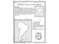
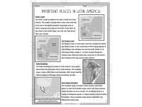
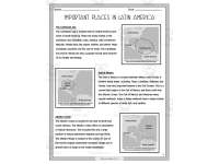
Yes. Students label oceans, draw the Amazon River, and shade the Andes, Amazon Rainforest, and Atacama Desert.
Are answer keys included?
Yes, the packet contains full keys for mapping, fill-in-the-blank items, and matching questions. 
What regions are covered?
The packet covers the Amazon River and Rainforest, Caribbean Sea, Gulf of Mexico, Atlantic and Pacific Oceans, Andes Mountains, Sierra Madre Mountains, Panama Canal, and Atacama Desert. 
About This Product
A reading and activity packet introducing key geographical locations across Latin America.
What's Included
Nine pages with reading passages, map activities, fill-in-the-blank questions, file-card tasks, and answer keys.
Standards & Curriculum
CCSS ELA (Grade 5):
CCSS.RI.5.1 - Quote accurately from a text when explaining what the text says explicitly and when drawing inferences from the text
CCSS.RI.5.7 - Draw on information from multiple print or digital sources, demonstrating the ability to locate an answer to a question quickly or to solve a problem efficiently.
Core Concepts:
Important landforms and waterways of Latin America
Human and physical geography
Map-reading skills and geographic identification
(NGSS/SS alignment: Geography—Human and Physical Systems)
Check out these other great products