United States Map: Fifty Labelled States
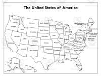
Locate all fifty US states on labelled maps in two print treatments, with Alaska and Hawaii shown as insets.


- Pages
- 2
- File type


- Subject
- History, Geography, Social Studies
- Resource types
- Worksheets
From the author
About this resource
The United States Map Labelled provides a visual overview of the country's geographical layout. This teaching resource suits various instructional contexts. The full-colour version bursts with vivid hues, enabling students to easily identify each state's location and outline. Its brightness makes it an ideal tool for teaching geography. Alternatively, the black and white adaptation allows for diverse applications like map colouring exercises or professional reports requiring formality. Both versions serve indispensable purposes: the coloured version offers immediate understanding while the monochromatic version provides versatility. Teachers can utilise these maps to plan engaging activities. Students gain familiarity with states' borders and neighbouring states. Whether adding liveliness to a lesson or serving formal presentations, this dual map set caters to diverse needs across education, business, travel, and government.
Related resources
More resources teachers may find useful
More resources on the same subject and topic.

In the classroom
Teaching tips & learning objectives

Learning objectives
- Locate any of the fifty states on a map of the United States
- Name the states that border a given state, using the labelled outlines
- Recognise how state size and shape vary between the western and north-eastern parts of the country

Teaching tips
- Point out the external labels for small northeastern states. Any blank-map exercise must be supplied separately.

Skills covered
- State identification — pupils find and name any of the fifty states from a single labelled map, including Alaska and Hawaii shown as insets.
- Reading a political map — the map shows state borders and names only, so pupils read boundaries rather than terrain or settlement.
- Regional awareness — the layout makes the contrast between the large western states and the small crowded north-eastern ones visible at a glance.
Good to know
Questions teachers ask about this resource
What is printed on the map besides the state names?
The title "The United States of America" and nothing else. There are no capitals, no cities, no rivers and no key, which keeps the page usable as a plain base for labelling, colouring or grouping work in a lesson.

No reviews yet
Downloaded this resource? Tell other teachers how it went.
Resource details
Core concepts
Core concepts
 Core concepts
- United States map
- States
- Political map
- Geography reference
Explore more
Categories this resource belongs to
Explore related searches


More to explore