Cardinal Directions: North America Map Questions
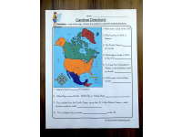
Use a North America map to describe relative locations with north, south, east and west. Ten questions refer to countries and bodies of water.

- Grades
- Grades 4–6
- Pages
- 1
- File type


- Subject
- Geography, Social Studies
- Resource types
- Worksheets
From the author
About this resource
This worksheet is a great way for students to practice using cardinal directions and map skills. By answering the questions, they will be able to better understand how to read a map. This is a valuable skill for students to have, and it will help them in their future studies.
Related resources
More resources teachers may find useful
More resources on the same subject and topic.


In the classroom
Teaching tips & learning objectives

Learning objectives
- Use cardinal directions to describe relative locations on a North America map
- Identify directional relationships among countries and bodies of water
- Determine a travel direction between two named map locations

Teaching tips
- Orient the map by locating north before reading the first question.
- Underline both locations in a prompt, then trace from the first place to the second before naming the direction.
- Distinguish questions asking where a place is from those asking which way a traveller would move.

Skills covered
- Map reading — learners locate named countries, oceans, bays, and seas on North America.
- Cardinal-direction reasoning — relative positions are expressed with north, south, east, or west.
- Route interpretation — travel questions require tracing movement from an origin to a destination.

No reviews yet
Downloaded this resource? Tell other teachers how it went.
Resource details
Core concepts
Core concepts
 Core concepts
- Cardinal directions
- North America
- Relative location
Explore more
Categories this resource belongs to
Explore related searches


More to explore