2,790 products added recently
Page 632 - Newest Teaching Resources
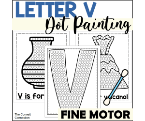
Letter V Dot Painting
ELA, Creative Arts, Art, Language Development, Phonics, Kindergarten, Preschool, Activities, Crafts
Title: Letter V Dot Painting Embrace an innovative approach to learning letters and boosting fine motor skills with these letter V dot painting worksheets. With this comprehensive resource, educators can engage students effectively while nurturing creativity and early literacy development. This package contains a total of 9 pages dot painting worksheets 1 vase dotting page 1 volcano dotting page 1 vulture dotting page One capital letter dot painting page One lowercase letter dot painting page One dot painting page with both capital and lowercase letters Two worksheets for students to independently design their own letter V Ways to Use: Art or Literacy Center - The teacher can place these worksheets with paint and cotton swabs in the center for students to complete. Quiet Time Activity - For programs that utilize nap times, these dot painting worksheets are perfect for teachers to give to those who do not nap as an activity to complete quietly. Morning Work - These worksheets are perfect to put out as morning work for students to work on while classmates arrive to class. Sub Plans - These worksheets make great sub plans as they are easy to explain and implement in the classroom. The Skills Assessed by This Activity : Promotes letter recognition and letter sound knowledge. Fosters important skills like hand-eye coordination and stimulates creativity as they choose colors and patterns specific to their personalized artwork. Builds fine motor skills while maintaining a clean learning environment owing to its low-mess nature. The Process: The process behind these activities couldn't be easier! There’s no preparation needed on part of teachers—simply print out these pages from our PDF file type. Students will need to be provided paint of various colors and cotton swabs to complete each page. The letter V dot painting worksheets reinforce learning while nurturing imagination amongst early learners - creating joyous educational experiences right at your fingertips.
Author The Connett Connection
Tags Dot Painting, Fine Motor Skills, Creativity, Early Literacy, Q-tip Painting, Alphabet Worksheets, Letter V, Letter V Activities, Letter V Workheets, Letter V Art
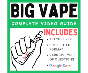
Complete Video Guide: Broken - Big Vape (2019)
P.E. & Health, Health, Grade 9, 10, 11, 12, Worksheets & Printables, Worksheets
Vaping refers to the act of inhaling and exhaling aerosol produced by an electronic cigarette or similar device. Over the years, there has been increasing concern about the use of vaping among teenagers. One of the main reasons for concern is the popularity of e-cigarettes and vaping products among teenagers. These products are often marketed with appealing flavors and sleek designs, which can be attractive to young people. Additionally, some teenagers may perceive vaping as a safer alternative to smoking traditional cigarettes, which can lead to experimentation and regular use. However, it is important to note that vaping can have negative health consequences, particularly for teenagers. The aerosol produced by e-cigarettes typically contains nicotine, which is highly addictive and can harm the developing adolescent brain. Nicotine addiction can have long-lasting effects and may increase the risk of future substance abuse. Furthermore, while e-cigarettes may contain fewer harmful chemicals compared to traditional cigarettes, they are not without risks. The aerosol can contain harmful substances such as heavy metals, volatile organic compounds, and flavoring chemicals that can cause respiratory and cardiovascular problems. The surge in vaping among teenagers has also raised concerns about a potential gateway effect. It is believed that vaping could lead to increased experimentation with other tobacco products, including cigarettes, cigars, and hookahs. To address these concerns, many countries and jurisdictions have implemented regulations to restrict the marketing and sale of vaping products to minors. Educational campaigns and interventions are also being conducted to raise awareness about the potential risks associated with vaping. Parents, educators, and healthcare professionals play a crucial role in educating teenagers about the risks of vaping and helping them make informed decisions. Encouraging open communication, providing accurate information, and promoting healthy alternatives can be effective strategies in addressing this issue. This amazing Netflix video helps outline the major causes and effects of the vaping epidemic. This is a teen-friendly video (explains the issues in a way that teenagers will understand). Initially designed for adult use, vaping has addicted teens to nicotine, thanks to hipster ads by startups like Juul. Now Big Tobacco's cashing in, and teens are finding themselves addicted. This product 24 questions that will help your students get the most out of this video. Ready to print - no prep. Here is the trailer to the documentary: Broken: Big Vape
Author EduPal Learning
Tags Vape, Vaping, Nicotine, Teenagers, Health, Character Education, Video Guide, Netflix, Big Vape Documentary, Big Vape Netflix, Complete Vape, Broken Vape

McFarland, USA (2015) : Complete Movie Guide
P.E. & Health, ELA, Reading, Reading Comprehension, Grade 6, 7, 8, 9, 10, Activities
Mcfarland, USA" is a sports drama movie directed by Niki Caro and produced by Walt Disney Pictures. The movie was released in 2015 and is based on a true story. The movie follows the story of a high school coach, Jim White, played by Kevin Costner, who moves to the small town of McFarland, California with his family. In McFarland, Coach White starts coaching the school's cross-country team, which is made up of a group of Latino students from low-income families. Despite initial challenges, Coach White is able to build a strong bond with the students and trains them to become a successful cross-country team. The movie portrays the challenges and obstacles the team faces, both on and off the track, and how they overcome them through their determination and hard work. This 24-question movie guide will help your students stay focused and it will help your students get the most out of this powerfully inspiring movie. This product includes a character chart as well as a critical thinking question for discussion. Ready to print and ready to use! No prep needed! Keep your students focused during this amazingly inspiration film! This movie is available on iTunes and Amazon. Follow me on Twitter: @PulgarinWill
Author EduPal Learning
Tags Video Guide, Physical Education , Movie Guide, Health, Full Movie Mcfarland Usa, Fall Movie Guide 2015, Mcfarland Usa Spanish Full Movie, Mcfarland Usa Movie Questions, Mcfarland Full Movie, Mcfarland Usa Clip, Mcfarland Usa Full Movie, Usa Mcfarland Full Movie

Hidden Figures (Movie Guide)
ELA, Social Studies, Reading, Reading Comprehension, History, History: USA, Grade 6, 7, 8, 9, 10, Worksheets & Printables, Worksheets
The film is based on the true story of three African-American women who played key roles in NASA's Space Race during the 1960s. The film follows the lives of Katherine Johnson, Dorothy Vaughan, and Mary Jackson, who work as mathematicians at NASA's Langley Research Center in Virginia. Despite facing racial and gender discrimination, the women use their intelligence and determination to break through barriers and make significant contributions to the space program. Katherine Johnson, portrayed by Henson, is a brilliant mathematician who becomes a crucial member of the team responsible for calculating the trajectory for John Glenn's historic orbit around the Earth. Vaughan, played by Spencer, becomes the supervisor of a group of "computers," women who manually do the calculations needed for the space program, and she teaches herself and her team how to program IBM computers. Jackson, played by Monáe, becomes NASA's first black female engineer, breaking through multiple barriers and fighting for her right to attend an all-white school to obtain her degree. The film also highlights the impact of the Civil Rights Movement on women's lives, as they navigate segregation and discrimination in their personal and professional lives. The movie is a tribute to their achievements and the contributions of African American women to the space program and the STEM field. Overall, Hidden Figures is an inspiring and important film that celebrates the resilience and brilliance of these women, as well as the power of determination and perseverance. It's a must-see for anyone interested in history, space exploration, and the fight for equality. This product includes 32 questions to help keep your students focused and engaged throughout the movie. The video guide is time-stamped, which allows teachers to chunk the movie into parts and to easily pick up where the class left off. I have also included a character reference guide and some "fact vs. fiction" insight into the movie. Lastly, this product comes with a complete teacher key. Ready to print and ready to use! This movie is available on iTunes and Amazon. Now compatible with Google Classroom and Schoology! Thumbnail Clipart Credit: By PrincePadania
Author EduPal Learning
Tags Movie Guide, History, African American History, STEM, Hidden Figures, NASA, Hidden Figures Full Movie, Hidden Figures Math Lesson Plan, Hidden Figures Full Movie Free, The American President Movie Guide Answer Key Pdf, Hidden Figures Questions, Hidden Figures Questions And Answers Pdf, Search For Hidden Figures
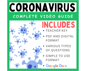
Coronavirus - Four Corners Documentary (2020): Complete Video Guide
P.E. & Health, Health, Grade 10, 11, 12, Activities
This documentary aired on ABC a couple of weeks ago. This documentary covers the start of the virus and the initial response by the Chinese government. This documentary covers the lockdown of Wuhan and the first attempts at containing the spread of the virus. Very informative and powerful! This guide comes with 18 questions that will help students understand the main points of the video. The video can be found on YouTube by typing this in: Coronavirus - Four Corners Documentary *** There is some foul language from some of the people interviewed. I could not find a version where these words were beeped out. Disclaimer: COVID-19 is a disease caused by the coronavirus SARS-CoV-2. It first appeared in late 2019 and quickly spread around the world, leading to a global pandemic. The virus primarily spreads through respiratory droplets when an infected person coughs, sneezes, talks, or breathes. Symptoms can vary from mild to severe and may include fever, cough, difficulty breathing, fatigue, loss of taste or smell, sore throat, and body aches. While most people recover without any serious problems, it can cause severe illness, especially in older adults and those with underlying health conditions. To protect against COVID-19, health experts recommend measures like wearing masks, practicing good hand hygiene, maintaining physical distance from others, and getting vaccinated. Vaccines have been developed and distributed globally to help prevent severe illness and reduce the spread of the virus. Efforts like these, along with increased awareness, testing, and medical advancements, have been crucial in managing and reducing the impact of COVID-19 on communities worldwide.
Author EduPal Learning
Tags Cornoavirus, COVID19, Pandemic, COVID, Video Guide, Documentary

The Pandemic, Explained (Video Guide)
P.E. & Health, Health, Grade 8, 9, 10, 11, 12, Activities
This enlightening series from Vox digs into a wide range of topics such as the rise of cryptocurrency, why diets fail, and the wild world of K-pop. In 2020, the world changed. This series The "Explained" video series explores various issues that are important to our lives. This new video looks at the Coronavirus that has gripped the world. This product comes with 12 questions that will help your students get the most out of this video. This product comes with a digital version that can be assigned on Google Classroom and Schoology. It also comes with the printable PDF version. Ready to use - no prep! It also comes with a digital version that can be assigned to students on Google Classroom, Schoology, or any other LMS. COVID-19 is a disease caused by the coronavirus SARS-CoV-2. It first appeared in late 2019 and quickly spread around the world, leading to a global pandemic. The virus primarily spreads through respiratory droplets when an infected person coughs, sneezes, talks, or breathes. Symptoms can vary from mild to severe and may include fever, cough, difficulty breathing, fatigue, loss of taste or smell, sore throat, and body aches. While most people recover without any serious problems, it can cause severe illness, especially in older adults and those with underlying health conditions. To protect against COVID-19, health experts recommend measures like wearing masks, practicing good hand hygiene, maintaining physical distance from others, and getting vaccinated. Vaccines have been developed and distributed globally to help prevent severe illness and reduce the spread of the virus. Efforts like these, along with increased awareness, testing, and medical advancements, have been crucial in managing and reducing the impact of COVID-19 on communities worldwide. This video series will help.
Author EduPal Learning
Tags Pandemic, COVID, Netflix, Video Guide, Causes Of COVID19, COVID19

Vocabulary with Cards | Crossword Wordsearch Anagram SUPERMARKET
Special Resources, ELA, Special Education Needs (SEN), Speech Therapy, Life Skills, Language Development, ESL, Writing, Handwriting, Spelling, Vocabulary, Not Grade Specific, Crosswords Puzzles, Worksheets, Worksheets & Printables
Vocabulary with Cards | Crossword Wordsearch Anagram SUPERMARKET This 25-page PDF resource provides educators with engaging vocabulary games and puzzles to help students learn new words related to the supermarket. Games like anagrams, crosswords, word searches, and more build language skills in a fun way. Use these printable activities during morning work, centers , or even as homework. The varied games suit different learning styles and can be adapted across grade levels. Beyond the classroom, these materials are great for speech therapy and special education needs. The supermarket theme creates real-world connections to help cement new vocabulary. Word lists cover useful grocery and shopping terminology. As students match, fill-in, and unscramble terms, they gain exposure to community concepts and written language conventions. These multi-purpose games build more than just direct vocabulary skills. As students read clues, unjumble letters, and complete puzzles, they also develop cognitive abilities, fine motor skills, and language arts fundamentals. Adaptable for individuals or groups, this engaging resource enriches any teaching environment.
Author WORDS ASIDE
Tags Flash Cards, Esl, Thematic Vocabulary, Word Wall, Independent Work, Centers, Writing Expository, Community, Words Aside, Shop

Vocabulary with Cards | Crossword Wordsearch Anagram SPORTS
Special Resources, ELA, P.E. & Health, Special Education Needs (SEN), Speech Therapy, Life Skills, Language Development, ESL, Writing, Handwriting, Spelling, Vocabulary, Physical Education, Sports, Not Grade Specific, Crosswords Puzzles, Worksheets, Worksheets & Printables
Vocabulary with Cards | Crossword Wordsearch Anagram SPORTS This 20-page PDF teaching resource helps students build vocabulary and knowledge around sports-related words and phrases. Educators can use the varied activities, including anagrams, crosswords, word searches, and more, to engage students meaningfully in language skills development. The sports-themed vocabulary words create context-based learning opportunities. The resource is versatile for whole group instruction, small group activities, learning stations, morning work, or even fun homework. Beyond the classroom, these materials are adaptable for therapy sessions targeting language development, vocabulary building, and conversation skills. With immediate use after printing, this non-grade specific resource allows flexibility across grade levels. The games build language arts mastery while assisting cognitive skills development across domains—supporting educators' goals for well-rounded growth.
Author WORDS ASIDE
Tags Flash Cards, Esl, Thematic Vocabulary, Word Wall, Independent Work, Centers, Writing Expository, Community, Words Aside, Sports
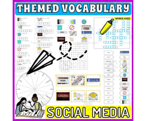
Vocabulary with Cards | Crossword Wordsearch Anagram SOCIAL MEDIA
Special Resources, ELA, Special Education Needs (SEN), Speech Therapy, Life Skills, Language Development, ESL, Writing, Handwriting, Spelling, Vocabulary, Not Grade Specific, Crosswords Puzzles, Worksheets, Worksheets & Printables
Word Games with Puzzles | Crossword Wordsearch Anagram | SOCIAL MEDIA . A resource designed especially for educators who value enhancing language skills in inventive ways . This pack provides a diverse set of word games and puzzles, all centered on the theme of SOCIAL MEDIA . Created to engage students meaningfully and rectify their knowledge about commonly used SOCIAL MEDIA-related words . Educators are provided with several varied activities: anagrams, copy words crossword, a blank writing board, lined writing board, word matching page, wheel chart and word search board . The chosen vocabulary words cater to useful SOCIAL MEDIA-related phrases, thus creating context-based learning . Versatility of the Resource . This versatile resource can be used in multiple ways . Kickstart the day with these activities as part of morning work routine or incorporate into teaching centers for active learning participation . Also use them as handouts or even as fun homework assignments which students would love to participate in! Beyond Classroom Applications . The application isn't just confined to the classroom alone; they are adaptable enough for therapy sessions too! Whether you are working on language development exercises like vocabulary enhancement or conversation prompts in group settings - these worksheets provide varied options that serve different purposes . You Receive : An easy-to-use package - an 20 pages pdf file combining worksheets and images ready for immediate use after printing! A non-grade specific resource- adaptable enough to be used by different grade levels conveniently! Note : These games not only concentrate on mastering language arts but also aid learners in understanding scientific and community concepts while assisting develop cognitive skills simultaneously! Conclusion : Enrich your teaching environment with this multi-faceted tool that aims not just at direct instruction but skill-building across various domains – a crucial aspect towards accomplishing holistic education! Included: 20 page PDF with word games worksheets and flash cards .
Author WORDS ASIDE
Tags Flash Cards, Esl, Thematic Vocabulary, Word Wall, Independent Work, Centers, Writing Expository, Community, Words Aside, Internet

Vocabulary with Cards | Crossword Wordsearch Anagram SOCCER
Special Resources, ELA, Special Education Needs (SEN), Speech Therapy, Life Skills, Language Development, ESL, Writing, Handwriting, Spelling, Vocabulary, Not Grade Specific, Crosswords Puzzles, Worksheets, Worksheets & Printables
Vocabulary Puzzles and Word Games : Soccer Engage students in learning new vocabulary words related to soccer with this versatile 24-page teaching resource. Educators are provided with a diverse set of word games and puzzles like anagrams, crosswords, word searches, and more to help students master commonly used soccer terms. These context-rich activities can be used for whole class instruction, small groups, morning work, homework, or even therapy sessions. The puzzles cater to a wide range of grade levels and provide opportunities for vocabulary development, language arts skills, cognitive growth, and concept learning. This ready-to-use PDF aims not just at direct instruction but also skill-building across various domains, allowing for adaptable and multi-faceted vocabulary instruction.
Author WORDS ASIDE
Tags Flash Cards, Esl, Thematic Vocabulary, Word Wall, Independent Work, Centers, Writing Expository, Community, Words Aside, Football

Vocabulary with Cards | Crossword Wordsearch Anagram SHOP
Special Resources, ELA, Special Education Needs (SEN), Speech Therapy, Life Skills, Language Development, ESL, Writing, Handwriting, Spelling, Vocabulary, Not Grade Specific, Crosswords Puzzles, Worksheets, Worksheets & Printables
Vocabulary with Cards | Crossword Wordsearch Anagram SHOP This 26-page PDF teaching resource builds vocabulary and literacy skills using the theme of SHOPPING. Educators are provided with engaging activities like anagrams, crosswords, word searches, and more to help students learn new vocabulary words related to shopping. Games like these make learning interactive and fun. This resource can be used in many ways - during morning work, centers , homework, or therapy sessions. The non-grade specific games work for a wide range of ages and support language development, cognitive growth, and real-world connections. With 7 different game types centered around shopping terms, this resource aims to advance skills across subjects through multi-faceted vocabulary instruction.
Author WORDS ASIDE
Tags Flash Cards, Esl, Thematic Vocabulary, Word Wall, Independent Work, Centers, Writing Expository, Community, Words Aside, Shop

Vocabulary with Cards | Crossword Wordsearch Anagram SCHOOL SUBJECTS
Special Resources, ELA, Special Education Needs (SEN), Speech Therapy, Life Skills, Language Development, ESL, Writing, Handwriting, Spelling, Vocabulary, Not Grade Specific, Crosswords Puzzles, Worksheets, Worksheets & Printables
Word Games with Puzzles | Crossword Wordsearch Anagram | SCHOOL SUBJECTS . A resource designed especially for educators who value enhancing language skills in inventive ways . This pack provides a diverse set of word games and puzzles, all centered on the theme of SCHOOL SUBJECTS . Created to engage students meaningfully and rectify their knowledge about commonly used SCHOOL SUBJECTS -related words . Educators are provided with several varied activities: anagrams, copy words crossword, a blank writing board, lined writing board, word matching page, wheel chart and word search board . The chosen vocabulary words cater to useful SCHOOL SUBJECTS -related phrases, thus creating context-based learning . Versatility of the Resource . This versatile resource can be used in multiple ways . Kickstart the day with these activities as part of morning work routine or incorporate into teaching centers for active learning participation . Also use them as handouts or even as fun homework assignments which students would love to participate in! Beyond Classroom Applications . The application isn't just confined to the classroom alone; they are adaptable enough for therapy sessions too! Whether you are working on language development exercises like vocabulary enhancement or conversation prompts in group settings - these worksheets provide varied options that serve different purposes . You Receive : An easy-to-use package - an 24 pages pdf file combining worksheets and images ready for immediate use after printing! A non-grade specific resource- adaptable enough to be used by different grade levels conveniently! Note : These games not only concentrate on mastering language arts but also aid learners in understanding scientific and community concepts while assisting develop cognitive skills simultaneously! Conclusion : Enrich your teaching environment with this multi-faceted tool that aims not just at direct instruction but skill-building across various domains – a crucial aspect towards accomplishing holistic education! Included: 24 page PDF with word games worksheets and flash cards .
Author WORDS ASIDE
Tags Flash Cards, Esl, Thematic Vocabulary, Word Wall, Independent Work, Centers, Writing Expository, Community, Words Aside, School
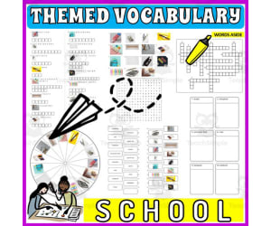
Vocabulary with Cards | Crossword Wordsearch Anagram SCHOOL ITEMS
Special Resources, ELA, Special Education Needs (SEN), Speech Therapy, Life Skills, Language Development, ESL, Writing, Handwriting, Spelling, Vocabulary, Not Grade Specific, Crosswords Puzzles, Worksheets, Worksheets & Printables
Word Games with Puzzles | Crossword Wordsearch Anagram | SCHOOL ITEMS . A resource designed especially for educators who value enhancing language skills in inventive ways . This pack provides a diverse set of word games and puzzles, all centered on the theme of SCHOOL ITEMS . Created to engage students meaningfully and rectify their knowledge about commonly used SCHOOL ITEMS-related words . Educators are provided with several varied activities: anagrams, copy words crossword, a blank writing board, lined writing board, word matching page, wheel chart and word search board . The chosen vocabulary words cater to useful SCHOOL ITEMS-related phrases, thus creating context-based learning . Versatility of the Resource . This versatile resource can be used in multiple ways . Kickstart the day with these activities as part of morning work routine or incorporate into teaching centers for active learning participation . Also use them as handouts or even as fun homework assignments which students would love to participate in! Beyond Classroom Applications . The application isn't just confined to the classroom alone; they are adaptable enough for therapy sessions too! Whether you are working on language development exercises like vocabulary enhancement or conversation prompts in group settings - these worksheets provide varied options that serve different purposes . You Receive : An easy-to-use package - an 24 pages pdf file combining worksheets and images ready for immediate use after printing! A non-grade specific resource- adaptable enough to be used by different grade levels conveniently! Note : These games not only concentrate on mastering language arts but also aid learners in understanding scientific and community concepts while assisting develop cognitive skills simultaneously! Conclusion : Enrich your teaching environment with this multi-faceted tool that aims not just at direct instruction but skill-building across various domains – a crucial aspect towards accomplishing holistic education! Included: 24 page PDF with word games worksheets and flash cards .
Author WORDS ASIDE
Tags Flash Cards, Esl, Thematic Vocabulary, Word Wall, Independent Work, Centers, Writing Expository, Community, Words Aside, School
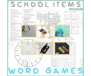
Word Games with Puzzles | Crossword Wordsearch Anagram | SCHOOL ITEMS
Special Resources, ELA, Special Education Needs (SEN), Speech Therapy, Life Skills, Language Development, ESL, Writing, Handwriting, Vocabulary, Not Grade Specific, Crosswords Puzzles, Worksheets, Worksheets & Printables
Word Games with Puzzles | Crossword Wordsearch Anagram | SCHOOL ITEMS . Designed for usage across multiple grade levels, this teaching resource known as 'Word Games with Puzzles' seamlessly integrates essential vocabulary study with an engaging cleaning theme . This resource is incredibly versatile and adaptable to fit a variety of learning environments . It invites educators in public schools, or even those that teach in a homeschooling setting, to invigorate their Language Arts curriculum while catering to educational trends including Special Education Needs (SEN), Speech Therapy, ESL instruction, and Life Skills lessons . The primary contents of the package comprise : Anagrams centered around key terms relevant to SCHOOL ITEMS such as ruler, eraser, marker etc. Copy words crossword puzzles that provide ample opportunity for learners to expand their vocabulary while indulging in interactive gameplay . The product also offers blank and lined writing boards perfect for handwriting practice . In addition, A word matching game ideal for reviewing new words picked up during the lesson or activity session . A wheel chart bundled within serves as an excellent tool for quick reference or review sessions conducted in small groups or one-on-one tutorial arrangements . A word search board challenges pupils further by letting them identify key keywords hidden amongst many irrelevant ones - offering both challenge and fun . Supplemental Materials include: Real photos along with whimsical illustrations serve dual purposes; they function not only as flashcards but also allow teachers to create visual folders thus adding versatility and creativity into everyday teaching circumstances . All elements included can double down both as part of your center 's resources library or can be handed out on individual bases hence serving multiple needs, from group-works to homework assignments . This brings you the valued flexibility everyone appreciates when it comes down classroom management - making this product extremely well-rounded. 11 page PDF file .
Author WORDS ASIDE
Tags Vocabulary Study, Interactive Gameplay, Handwriting Practice, Word Search, Visual Aids, Word Wall, Crossword, Esl, Independent Work, Words Aside

Country Study Presentation on Germany
Social Studies, History, History: Europe, Geography, Grade 7, 8, 9, 10, 11, 12, Teacher Tools, Presentations
Country Study Presentation on Germany This Teaching Resource is an Introductory PDF Presentation (15 Slides) on Germany. This Digital Resource can be great for Geography, European History and Social Studies Classes. Suitable Learners for this kind of lesson are students from 7th Grade to 12th Grade. This Geography + Social Studies Presentation on Germany (Country Study) aims to introduce learners to Germany (its most important and basic facts, language, history, environment, economy and basic German vocabulary). No or little preparation is needed. Within this Introductory Presentation on Germany (PDF Country Study Teaching Resource) it is offered: a first slide with greetings in German Language (Guten Tag + Hallo) with QR Codes and link to YouTube Video to learn how to pronounce it properly in German language 2 slides on Germany + its basic geography and borders (Google Maps Link directed to Germany's geographical location included) a "quick data on Germany" slide (currency, population etc) 2 slides on German Language (one as an introduction to German and a second one with basic German Language Vocabulary) 2 slides with Germany's History timeline (from the first Germanic Peoples to Angela Merkel first Woman Chancellor of Germany) 1 Slide on Geographical facts (size, kind of territory and weather) 1 on German Economy 1 on Berlin 1 on other cities in Germany (little map of Germany with German cities such as Hamburg, Leipzig, Munich etc.) 1 slides on German Culture (German Cuisine and German Literature, Philosophers and Music Composers) 1 last slide with Goodbye written in German (Auf Wiedersehen) with QR Code-Linked YouTube Video on how to pronounce it This Social Studies + Geography Country Study on Germany PDF Digital Teaching Resource (15 slides) can be great for learners from 7th grade to 12th grade to introduce Germany and its Culture. Learning with Alan is a Brand New Teaching Resource/Educational Material Store whose aim is to help Teachers, Educators and Tutors to achieve their teaching objectives while creating a fun and stimulating environment. Never Forget! If you want to browse more of my Teaching Resources, click here Learning with Alan!
Author Learning with Alan
Tags Germany, Europe, Geography, European History, Social Studies, Country Study, German Culture, Presentation, Teaching Resource, Culture

Vocabulary with Cards | Crossword Wordsearch Anagram FAST FOOD
Special Resources, ELA, P.E. & Health, Special Education Needs (SEN), Speech Therapy, Life Skills, Language Development, ESL, Writing, Handwriting, Spelling, Vocabulary, Health, Not Grade Specific, Crosswords Puzzles, Worksheets, Worksheets & Printables
Vocabulary with Cards | Crossword Wordsearch Anagram FAST FOOD This 24-page PDF teaching resource builds vocabulary and literacy skills using the theme of fast food. Games like anagrams, crosswords, and word searches engage students with context-based learning focused on frequently used words and phrases related to fast food. These printable activities can be used for morning work, centers, homework, or therapy sessions to develop language, cognitive skills, and real-world understanding. With multiple activity types that work for various grade levels, this versatile resource saves teachers time while giving students fun practice with vocabulary, spelling, reading, and more. Use it for individual, small group, or whole class instruction to liven up language arts lessons or speech therapy sessions.
Author WORDS ASIDE
Tags Flash Cards, Esl, Thematic Vocabulary, Word Wall, Independent Work, Centers, Writing Expository, Community, Words Aside, Food

30 ANIMALS PUZZLES For Kids - Print ant Cut FREE
Creative Arts, Art, Kindergarten, Preschool, Grade 1, 2, Activities, Crafts
1. Introduction As is known, puzzles are an educational and fun activity for children, because they offer a variety of advantages and benefits for their cognitive, emotional and social development. For this reason, today I present this fascinating worksheet where your students can work on 4-part puzzles about animals. 2.Objective The objectives of this educational puzzle sheet are: - Develop fine motor skills: Solving puzzles involves varied activities such as manipulating small pieces and then fitting them together correctly and perfectly, which will help the student develop fine motor skills. These types of fine motor skills are essential for daily activities that they will later perform such as writing, manipulating small objects and even buttoning buttons. - Cognitively stimulate: Puzzles, as it is known, make children think and solve problems to then find the correct location of each piece. This entire process will strengthen memory, attention, concentration and even other types of essential cognitive skills. - Encourage logical thinking: When solving puzzles, students must learn to follow a logical order and also understand how the pieces fit together. This will help develop logical and sequential thinking skills, which is beneficial for scientific and mathematical learning. - Develop patience and perseverance: When solving a puzzle, children face a challenge, in this way they will be learning to be patient as well as persistent in their effort to finish and complete it. All of these values are very useful in many aspects of your daily life and for your learning experience. - Promote teamwork as well as social interaction: When children solve puzzles as a group, they will learn to collaborate, share ideas, and even work together to achieve a common goal: the finished puzzle. This educational activity will encourage them to develop emotional and social skills, such as teamwork, communication and empathy. In summary, puzzles are a valuable tool for the comprehensive development of students, which offers great benefits on a mental and physical level, thus contributing to their social, emotional and cognitive growth. 3.Order, scheme and stages First introduce your class with a motivating activity that awakens the curiosity of your students, and then just introduce this worksheet. 4.Grades or ages This worksheet is intended for children ages 4 to 8. 5. Form of application This educational sheet can be applied individually or in groups. 6. Answer keys This game does not require answers. 7.Use text labels puzzles, puzzle for kids, printables for kids, printables 8.Rules Specified above. 9.File types The archive is in PDF format. 10.Number of pages This document contains 30 pages.
Author EDITORIAL LAURA EDUCA
Tags Puzzles, Puzzle, Print And Cut

Vocabulary with Cards | Crossword Wordsearch Anagram TRANSPORTATION
Special Resources, ELA, Special Education Needs (SEN), Speech Therapy, Life Skills, Language Development, ESL, Writing, Handwriting, Spelling, Vocabulary, Not Grade Specific, Crosswords Puzzles, Worksheets, Worksheets & Printables
Vocabulary with Cards | Crossword Wordsearch Anagram TRANSPORTATION This 24-page PDF teaching resource helps students build vocabulary and literacy skills related to transportation. Educators can use the varied activities, including anagrams, crosswords, word searches, and more, to engage learners. The transportation-themed vocabulary words allow for context-based learning. Students match terms to definitions, fill in crossword puzzles, unscramble anagrams, and search for hidden words. These interactive games build language, reading, critical thinking, and problem-solving abilities. Teachers can incorporate the reproducible packet during morning work, literacy centers , or assign it for homework. Beyond the classroom, speech therapists may utilize the materials during vocabulary lessons. With universal themes, this versatile resource suits diverse needs from elementary through high school.
Author WORDS ASIDE
Tags Flash Cards, Esl, Thematic Vocabulary, Word Wall, Independent Work, Centers, Writing Expository, Community, Words Aside, Vehicles

Vocabulary with Cards | Crossword Wordsearch Anagram PORT SHIP
Special Resources, ELA, Special Education Needs (SEN), Speech Therapy, Life Skills, Language Development, ESL, Writing, Handwriting, Spelling, Vocabulary, Not Grade Specific, Crosswords Puzzles, Worksheets, Worksheets & Printables
Word Games with Puzzles | Crossword Wordsearch Anagram | PORT SHIP . A resource designed especially for educators who value enhancing language skills in inventive ways . This pack provides a diverse set of word games and puzzles, all centered on the theme of PORT SHIP . Created to engage students meaningfully and rectify their knowledge about commonly used PORT SHIP-related words . Educators are provided with several varied activities: anagrams, copy words crossword, a blank writing board, lined writing board, word matching page, wheel chart and word search board . The chosen vocabulary words cater to useful PORT SHIP-related phrases, thus creating context-based learning . Versatility of the Resource . This versatile resource can be used in multiple ways . Kickstart the day with these activities as part of morning work routine or incorporate into teaching centers for active learning participation . Also use them as handouts or even as fun homework assignments which students would love to participate in! Beyond Classroom Applications . The application isn't just confined to the classroom alone; they are adaptable enough for therapy sessions too! Whether you are working on language development exercises like vocabulary enhancement or conversation prompts in group settings - these worksheets provide varied options that serve different purposes . You Receive : An easy-to-use package - an 25 pages pdf file combining worksheets and images ready for immediate use after printing! A non-grade specific resource- adaptable enough to be used by different grade levels conveniently! Note : These games not only concentrate on mastering language arts but also aid learners in understanding scientific and community concepts while assisting develop cognitive skills simultaneously! Conclusion : Enrich your teaching environment with this multi-faceted tool that aims not just at direct instruction but skill-building across various domains – a crucial aspect towards accomplishing holistic education! Included: 25 page PDF with word games worksheets and flash cards .
Author WORDS ASIDE
Tags Flash Cards, Esl, Thematic Vocabulary, Word Wall, Independent Work, Centers, Writing Expository, Community, Words Aside, Ship
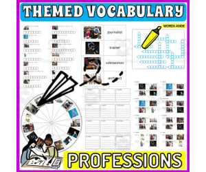
Vocabulary with Cards | Crossword Wordsearch Anagram PROFESSIONS
Special Resources, ELA, Special Education Needs (SEN), Speech Therapy, Life Skills, Language Development, ESL, Writing, Handwriting, Spelling, Vocabulary, Not Grade Specific, Crosswords Puzzles, Worksheets, Worksheets & Printables
Vocabulary with Cards | Crossword Wordsearch Anagram PROFESSIONS This 25-page PDF teaching resource builds vocabulary and language skills by focusing on professions-related words. Games like anagrams, crosswords, word searches, and more engage students meaningfully while reinforcing commonly used career vocabulary. Educators can use these versatile activities during morning work, centers , assignments, therapy sessions, or whereever vocabulary development is needed. The non-grade specific format is adaptable for different ages and settings like whole group, small group, individuals, or homework. Students will enjoy participating in the varied games that aim not just at direct instruction but at building skills holistically across language arts, cognition, and community awareness.
Author WORDS ASIDE
Tags Flash Cards, Esl, Thematic Vocabulary, Word Wall, Independent Work, Centers, Writing Expository, Community, Words Aside, Professions

Vocabulary with Cards | Crossword Wordsearch Anagram PHARMACY
Special Resources, ELA, P.E. & Health, Special Education Needs (SEN), Speech Therapy, Life Skills, Language Development, ESL, Writing, Handwriting, Spelling, Vocabulary, Health, Not Grade Specific, Crosswords Puzzles, Worksheets, Worksheets & Printables
Vocabulary with Cards | Crossword Wordsearch Anagram PHARMACY This 24-page PDF teaching resource builds vocabulary and language skills using interactive puzzles and games related to pharmacy and medicine. Educators can use the varied activities like anagrams, crosswords, and word searches to help students learn common pharmacy terms and improve literacy abilities. The vocabulary focuses on practical medical phrases to promote real-world learning. Teachers can incorporate these printables during morning work, centers , assignments, therapy sessions, or homework. The non-grade specific games allow flexible use by multiple age groups. With engaging and meaningful vocabulary practice, this resource aims to build language arts skills while assisting cognitive and community understanding. The multi-faceted tools promote active participation and skill-building across subjects - working towards holistic education.
Author WORDS ASIDE
Tags Flash Cards, Esl, Thematic Vocabulary, Word Wall, Independent Work, Centers, Writing Expository, Community, Words Aside, Medicine

Country Study on Germany Snakes and Ladders Board Game PDF Printable
Social Studies, Geography, History, History: Europe, Grade 7, 8, 9, 10, 11, 12, Worksheets, Worksheets & Printables
Country Study on Germany Snakes and Ladders Board Game PDF Printable This Teaching Resource is a PDF Board game (Snakes and Ladders; 3 slides) on Germany (Europe). This Printable Resource can be great for Geography, European History and Social Studies Classes. Suitable Learners for this kind of lesson are students from 7th Grade to 12th Grade. This Geography + Social Studies game on Germany (country Study) aims to test learners on their knowledge on Germany and German Culture (naming 4 German cities, telling about history events, telling about your pawn's character, telling about 6 Famous German individuals or telling what you would like to visit in Germany). Some preparation on Germany, German Culture and History can be useful for this Social Studies Activity. Within this amazing Country Study on Germany (Europe) board game (snakes and ladders; 3 PDF Printable slides) it is offered: 1 board with questions and Speaking Prompts (ex. name 4 German Cities or telling about German history events such as the Fall of the Berlin Wall or the Gutenberg Bible etc) 1 Printable Craft Die with numbers written 1 Printable Craft cone to make Game Pawns to play 5 Famous People from Germany such as (Johann Sebastian Bach, Martin Luther, Immanuel Kant, Ludwig van Beethoven, etc.) to stick on the players' printable craft cone This amazing and fun Social Studies + Geography Country Study on Germany (Europe) PDF Digital Teaching Resource (3 PDF Printable Slides) can be great for learners from 7th grade to 12th grade to test Germany and its Culture. Learning with Alan is a Brand New Teaching Resource, Educational Material Store whose aim is to help Teachers, Educators and Tutors to achieve their teaching objectives while creating a fun and stimulating environment. Never Forget! If you want to browse more of my Teaching Resources, click here Learning with Alan
Author Learning with Alan
Tags Europe, Geography, Social Studies, Snakes And Ladders, Germany, German Culture, Culture, Printable, Game, PDF

Country Study on Germany - Research Project + Cards + Worksheets
Social Studies, Geography, History, History: Europe, Research, Grade 7, 8, 9, 10, 11, 12, Projects, Activities
Country Study on Germany - Research Project + Cards + Worksheets This Teaching Resource is a PDF research project (10 Slides) on Germany. This Printable Resource can be great for Geography, European History and Social Studies Classes. Suitable Learners for this kind of lesson are students from 7th Grade to 12th Grade. This Geography + Social Studies Research Project on Germany (country Study) aims to make learners discover Germany (history, geography, economy, Berlin and culture). Little preparation can be helpful. Within this Country Study on Germany Research Project, it is offered: 2 worksheets to write research outcomes 64 Cards to fish for this Research Project on Germany How does this Country Study on Germany Teaching Resource work? learners (or groups) fish a Research Topic card of each color (black for history, blue for geography, orange for economy, Red for Berlin and green for German Culture) each student or group makes their personalized Research on Germany, by focusing on their fished topic cards (ex. fished black card on history on "Gutenberg Bible", blue card on geography on "the Rhine River", orange card on economy on "Tertiary Sector", Red Cards on Berlin on the Brandenburg Gate and a green card on German Culture on Immanuel Kant) Learners stick their fished cards on their research worksheet and write their Research outcomes Learners make a presentation on their personalized rersearch on Germany teacher evaluates research given learner or group's research outcomes written on worksheets Why is this Teaching Resource worth using? By fishing topic cards, students have a chance to: make unique randomized research projects focus on specific topics only and discover more the research country in "non-superficial" ways Connect their own Research outcomes with their peers' This Social Studies + Geography Country Study on Germany PDF Printable Research Project on Germany Teaching (10 slides) can be great for learners from 7th grade to 12th grade to introduce Germany and its Culture. Learning with Alan is a Brand New Teaching Resource/Educational Material Store whose aim is to help Teachers, Educators and Tutors to achieve their teaching objectives while creating a fun and stimulating environment. Never Forget! If you want to browse more of my Teaching Resources, click here Learning with Alan!
Author Learning with Alan
Tags Germany, Country Study, Research Project, Europe, European History, Geography, Research, Social Studies, Printable, Worksheet
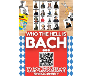
Country Study on Germany - Guess Who Game on famous German People
Social Studies, Geography, History, History: Europe, Grade 6, 7, 8, 9, 10, 11, 12, Activities, Games
Country Study on Germany - Guess Who Game on famous German People This Teaching Resource is an fun Guess Who Game PDF Presentation (1 slide, 20 cards) on Famous German People. This Printable Resource can be great for Geography, European History and Social Studies Classes. Suitable Learners for this kind of lesson are students from 6th Grade to 12th Grade. This Geography + Social Studies Guess Who Game on Famous People from Germany (Country Study) aims to introduce learners to Germany and its most famous people (leaders, kings, philosophers, writers etc.). Little Preparation is needed for this Social Studies + Geography Activity. Some of the German People selected for this Geography + Social Studies + European History Country Study on Germany are: the Brothers Grimm Thomas Mann Richard Wagner Johannes Brahms Johann Sebastian Bach Goethe Gottfried Wilhelm con Leibnitz Arthur Schopenhauer Hegel Immanuel Kant Ludwig van Beethoven Otto von Bismarck Angela Merkel Martin Luther and many more! a very fun and engaging way to play this "Guess Who on Famous People from Germany" (country study on Germany) game can be the following: all Learners sit on the floor in a circle every Learner has a Flash Card on their face every Learner/player asks a question about their Flash Card 's famous German character This Social Studies + Geography Country Study on Germany PDF Printable Teaching Resource (1 slide, 20 cards for 20 Famous People from Germany) can be great for learners from 6th grade to 12th grade to introduce Germany and its Culture through its most important and celebrated people. Learning with Alan is a Brand New Teaching Resource/Educational Material Store whose aim is to help Teachers, Educators and Tutors to achieve their teaching objectives while creating a fun and stimulating environment. Never Forget! If you want to browse more of my Teaching Resources, click here Learning with Alan!
Author Learning with Alan
Tags Germany, Europe, European History, Social Studies, Geography, Printable, Cards, Guess Who, Culture, Game