2,755 products added recently
Page 65 - Social Studies Worksheets
Enhance your social studies curriculum with worksheets covering geography, history, civics, and cultures. These resources include maps, timelines, and critical thinking exercises. Use them to deepen understanding of societal structures and encourage informed citizenship.

America Story of Us: Episode 4 - "Division" - Complete Video Guide
Social Studies, History, History: USA, Grade 7, 8, 9, 10, 11, Worksheets & Printables, Worksheets
Video overview: Commerce and industry thrive across the new nation, now one of the wealthiest on Earth. The Erie Canal brings big risk and bigger reward. In the South, cotton is king but slavery fuels a growing divide. Violence flares across the territories and abolitionists make a stand for freedom. The election of Lincoln is a harbinger of war. Slavery: The institution of slavery was a central and divisive issue leading up to the Civil War. The Southern states heavily relied on slave labor for their agricultural economy, while the Northern states had gradually abolished slavery. The disagreement over the expansion of slavery into new territories and the moral and economic implications of the institution created significant tensions between the North and the South. States' Rights: The conflict between states' rights and federal authority played a role in the lead-up to the Civil War. Southern states believed in the concept of states' rights, arguing that states had the authority to nullify federal laws or secede from the Union if they deemed it necessary to protect their interests. This clashed with the belief in a strong federal government held by many in the North. Sectionalism: Sectionalism, the division of the country along regional lines, also contributed to the causes of the Civil War. The North and the South had different economies, social structures, and cultural values, leading to increasing tensions and rivalries between the regions. Economic Differences: The North experienced rapid industrialization, urbanization, and a diversified economy, while the South relied heavily on agriculture, particularly cotton production using slave labor. Disagreements over tariffs, trade policies, and economic interests further deepened the divide between the North and the South. Political Climate: Political differences and conflicts over slavery and its expansion into new territories heightened tensions between Northern and Southern politicians. The rise of anti-slavery sentiment and the formation of new political parties, such as the Republican Party, contributed to the growing polarization between the North and the South. Failure of Compromises: Various attempts at compromise, such as the Missouri Compromise of 1820 and the Compromise of 1850, aimed to address the issue of slavery but ultimately failed to resolve the deep-rooted divisions. These failures highlighted the inability to find a peaceful and lasting solution to the contentious issue of slavery. It's important to note that the causes of the Civil War are complex and interconnected, and different historians may emphasize different factors. The issues surrounding slavery and its expansion were undoubtedly central to the conflict, but they were intertwined with broader political, economic, and social tensions that had been building for decades. These teacher-generated questions are designed to help students focus in on key information during the video. These questions cover the fourth episode in the series titled "Division." Ready to print and use! Comes with a completed answer key! Thumbnail Clipart Credit: By Prince Padania
Author EduPal Learning
Tags Civil War, Antebellum South, Slavery, States' Rights, Sectionalism, Election Of 1860, Abraham Lincoln, Secession

Geography: China
Social Studies, Geography, Grade 1, 2, 3, 4, Worksheets & Printables, Worksheets
Geography: China Teaching Resource This Geography: China teaching resource is a well-designed and captivating tool, best suited for teachers looking to make their geography curriculum more exciting or homeschooling parents in need of resourceful teaching content. It's best utilized by students from grade 1 to grade 4, focusing on core geographic principles found within the rich cultural scope of China. Worksheets for Learning The toolkit encourages learners to explore map work and compass points, crucial elements of geographical understanding. Within its fully editable three-page booklet, you'll find an accurate depiction of China’s topography. Students interact with hands-on exercises concerned with cardinal and intercardinal directions (8-point compass), enhancing their spatial awareness while also gaining knowledge about one of the world's most ancient civilizations. Versatility in Teaching Methods Educators can seamlessly integrate this comprehensive geography teaching resource into a variety of instruction formats: Whole group instruction: Promotes collaborative learning. Small-circle discussions: Stimulates engaging exchanges between peers. Homework assignments: Reinforce classroom learning. Independent studies: Nurtures self-regulated learning skills among students. Serving different educational needs without compromising pedagogical quality gives educators multiple options to diversify their technique when educating historical geography. User-friendly Access for Teachers For hassle-free use by busy educators who prioritize effective lesson planning, the resource is provided as a Zip file which allows convenient storage and easy access when needed. The Geography: China, offering insightful geographic information while imbuing young minds with curiosity about diverse cultures and lands beyond their immediate environments. Its value is priceless in helping to create global appreciation among budding scholars; training enlightened citizens for tomorrow's global society.
Author Elementary Resources 4 U
Tags Geography, China, Map Skills, Compass Points, Cultural Understanding
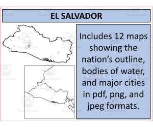
El Salvador Map Resources
Social Studies, Geography, Not Grade Specific, Worksheets & Printables, Worksheets
Product Title: El Salvador Map Resources This product is a comprehensive compendium of detailed maps centered on the nation of El Salvador. As an instructional tool, it is designed to enhance and fortify the teaching materials in subjects like Social Studies and Geography. These resources are not grade-specific, making them versatile and applicable across various educational levels. Package Description: The package contains twelve individual map sheets that cater to diverse teaching requirements. Each map is provided in three different formats for ease of use: PDF for printing, JPEG for digital display, and PNG with a transparent background suitable for overlay purposes or custom backgrounds. Included Features: Within these El Salvador maps, educators will find different versions that focus on various aspects like blank outlines ideal for labeling exercises or contour mapping; bodies of water showcasing important aquatic features; major settlements highlighting urban landscapes as well as highly populated regions.. One unique feature includes maps presenting El Salvador individually or in context with its neighboring countries so students can appreciate its geographical location relative to other nations better. Apart from personal usage in instruction delivery or classroom activities such as quizzes/tests and project works, these maps are also available for integration into your own created products under certain terms outlined on the preview sheet. Bonuses: This product presents access links—for free—to additional resources like the United States Maps to enrich your instructional content further. If you're looking for more global geographic coverage in your teaching toolkit then consider checking out our complete bundle offering 194 different nations at a significantly discounted price. This wide-ranging product supplies quality cartographic resources which can be distinctly valuable across multiple grade levels -whether you are operating within a public school setting or homeschooling environment- expanding both the scope and depth of students' geographic understanding. This set has been thoughtfully designed using varied map types to accommodate multiple learning objectives related specifically towards geography instruction. Visit my store here for similar resources!
Author Mr Gray History
Tags El Salvador, Geography Resources, Map Collection, Teaching Tool, Country Study
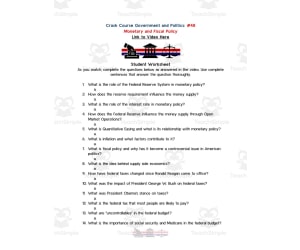
Crash Course Government Episode | 48 - Monetary and Fiscal Policy
Social Studies, Government, Grade 7, 8, 9, 10, Worksheets & Printables, Worksheets
Engage students in learning about monetary and fiscal policy with this 2-page worksheet based on the Crash Course Government video episode. With 15 short answer questions that prompt critical thinking, this resource challenges learners to analyze how the government utilizes monetary and fiscal policies to influence economic outcomes. Easily implement as an individual assignment or small group activity. An answer key allows students to self-check their work. Pair with the 9-minute Crash Course video to scaffold understanding of complex economic concepts like quantitative easing and government spending. This stand-alone worksheet on monetary and fiscal policies is an educational supplement for civics, economics, and government courses in grades 7-10. Check out other social studies resources at Active Social Studies for inspiring students to be informed, engaged citizens.
Author Ed Dynamic
Tags Crash Course Videos, Monetary Policy, Fiscal Policy, Government Policies, Government Regulations, Government Video, Government Worksheet, Crash Course Fiscal Policy

Crash Course Government Episode Worksheet | 30 - Sex Discrimination
Social Studies, Government, Grade 7, 8, 9, 10, Worksheets & Printables, Worksheets
Crash Course Government Episode Worksheet | 30 - Sex Discrimination Understanding history, politics, and government can be a challenging task for students. The Crash Course Government Episode Worksheet on Sex Discrimination bridges this gap by offering an engaging and interactive way to connect the past with the present. This valuable educational resource specifically focuses on sex discrimination while enriching governmental systems knowledge. This instructive aid comes in two separate Word documents over four pages- one with the worksheet itself and another containing answers for convenient marking or self- assessment . The worksheet has 15 thought-provoking questions that challenge students' intellectuality. A weblink is provided that directs students directly to the corresponding 'Crash Course' video on YouTube. The focus episode – “Sex Discrimination” runs approximately eight minutes long making it suitable for class schedules without being exhaustive. This versatile teaching tool can easily fit into various classroom setups- from solitary homework assignments to collaborative group projects or guided whole-class activities. Suitable for grades 7 through 10- educators from diverse arenas like public schooling environments to homeschooling setups would find this worksheet advantageous. Suggested resources: American Civil Rights Lecture, 28th Amendment Project, Major Constitutional Clauses Lecture, (Links Commit) “ArcticSurvivalTeamBuildingActivity.“ These worksheets offer a fresh approach to teaching by captivating student's attention and broadening their understanding of American government.
Author Ed Dynamic
Tags History, Politics, Government, Sex Discrimination, Education

Canada Spelling List
Social Studies, History, History: Canada, Grade 2, 3, 4, Worksheets & Printables, Worksheets
Discover Canada with this engaging spelling list for elementary students! The All About Canada Spelling List introduces learners to 13 essential vocabulary words related to the geography, culture, and government of Canada. With syllables broken down and pronunciations included, students will build fluency as they learn to spell essential words like "Canada," "province," "Toronto," "maple," and more. The list incorporates motivating bonus words like "Saskatchewan," "Vancouver," and "parliament" to spark interest. Whether utilized for whole group instruction, independent practice, or homework, this concise 2-page spelling resource provides a fun way to explore Canada while improving spelling skills.
Author Mr. Matthews Teacher Store
Tags Canada, Spelling, Vocabulary, Social Studies

US State Study Guide Worksheets on Maryland
Social Studies, Economics, First Peoples (Native), Geography, Government, History, History: USA, Grade 7, 8, 9, 10, 11, 12, Worksheets & Printables, Worksheets
US State Study Guide Worksheets on Maryland Bring the rich history, geography, and cultural identity of Maryland to life with this US State Study Guide on Maryland —a dynamic printable teaching resource tailored for Grades 7 through 12 . Perfect for Geography , Social Studies , and US History classes, this ready-to-use 2-page PDF worksheet pack engages students with interactive, standards-aligned activities that promote state-specific learning in a meaningful, creative way. What’s Included: ✅ 2 Printable PDF Worksheets – Easy-to-print and classroom-ready, designed with clear sections and visually engaging layouts. ✅ QR Code Integration – Instantly transport your students to Maryland's geographic location on Google Maps to visually explore its position within the United States. ✅ Etymology Activity – Dive into the origin and meaning of the name “Maryland” , connecting linguistic history with cultural understanding. ✅ General State Information Task – Guide students to summarize key facts about Maryland , including nickname, motto and more. ✅ Geography-Focused Questions – Students will write down the names of the states bordering with Maryland and they will write about its climate and territory ✅ History Timeline – Includes a blank timeline for learners to research and record major historical events , from early statehood to modern milestones. ✅ Economy Exploration – This activity lets students examine Maryland’s economic sectors , such as agriculture, manufacturing, aerospace, and tech industries. ✅ Capital City Focus: writing the name of the capital city + 7 sights ✅ Top 5 Cities Activity – Learners will research and list five major cities in Maryland This Maryland US State study consists of 2 PDF printable worksheets, perfect for engaging students in grades 7th-12th as they explore the history and geography of this US State Learning with Alan is dedicated to supporting teachers, educators, and tutors in achieving their teaching goals while fostering an engaging learning environment. Learning is Fun. Never Forget! For more of my Teaching Resources, click here Learning with Alan
Author Learning with Alan
Rating
Tags Social Studies, Geography, Study Guide, Maryland, USA, US States, US History, Activity, Worksheets, Printable

Poland Map Resources
Social Studies, Geography, Not Grade Specific, Homeschool Resources, Worksheets & Printables, Worksheets
Poland Map Resources Designed with public school teachers and homeschoolers in mind, our Poland Map Resources is an effective educational tool. This resource comprises twelve individual map sheets, each presented in three common file formats (pdf, jpeg, and png) for convenience of use across various platforms. Blank Outlines : Perfect for testing geography knowledge or coloring exercises. Bodies of Water: Showcasing picturesque bodies of water dispersed through this Eastern European country. Majors Settlements: Featuring maps showing major settlements, conveying cultural richness and variance within the nation's borders. We also provide perspective on both Inward and Outward levels,. You will find maps showing Poland in isolation helping with memorization and recognition; other maps present Poland alongside its neighboring nations supporting discussions around geopolitics or integrated world geography lessons. Note:Certain creative use permissions are provided by following guidelines detailed in our instructions sheet accompanying these files. Select Your Desired Maps Across 194 Nations! If you wish to teach about countries worldwide beyond Europe alone, we offer similar resources related to an astounding 194 nations at a significantly reduced bundle price point that proves extremely economical over individual purchases. No Grade Limitations! Applicable across multiple grades without any specific grading limitation ensures this product’s wide usage range catering all levels where Geography forms part of teaching disciplines under Social Studies subject line mostly robustly utilized through worksheet format instructional styles across homeschooling settings or public-institution environments alike. All Files Are Delivered In Zip Format For Convenience And Quality Preservation: Compressed zip file format delivery assures hassle-free downloading while preserving optimal quality across multiple files helping easy manageability right out-the-box from download point onwards for immediate plug-n-play readiness!
Author Mr Gray History
Tags Poland Maps, Geography Resources, Lesson Planning, Homeschooling Tools, Cross-Cultural Education

Kentucky Map Scavenger Hunt
Social Studies, Geography, Grade 4, 5, 6, Worksheets & Printables, Worksheets
Introducing a fun and engaging Kentucky map scavenger hunt for intermediate elementary students. This 4-page printable allows students to explore a map of Kentucky using cardinal and intermediate directions to find important state landmarks. By answering specific questions, learners will locate major cities, bodies of water, landforms, national parks and monuments, as well as the state capital. An excellent standalone Kentucky geography activity or complement to a wider United States geography unit. This printable encourages critical thinking skills as students use a hands-on approach to analyze an informative state map. Applicable as an individual, small group, or whole-class activity to assess knowledge of Kentucky's important geographical features.
Author Mr. Matthews Teacher Store
Tags Kentucky, Map Skills, Scavenger Hunt, Geography, Landforms, Cities, Capital

Barbados Map Resources
Social Studies, Geography, Not Grade Specific, Worksheets & Printables, Worksheets
Barbados Map Resources An Ideal companion for any social studies or geography curriculum . Specially designed for students and educators, this is an easy-to-use tool that can enhance your lessons about Barbados. About the Maps Our product provides a comprehensive set of maps showcasing the island nation of Barbados. It includes three separate sheets in PDF, JPEG, and PNG formats for ease of use on different platforms. The first map outlines the coastal contours and interior details, The second map focuses on bodies of water making it useful for demographic studies or climate discussions, The third one highlights major settlements thereby critical information when discussing socio-economic aspects. Precision and Versatility Each map has been created with precision and clarity to allow a clear understanding of various geographical features. This multi-format offering allows you to integrate these maps into presentations or interactive activities effectively. A Resource Appropriate Across Different Levels This versatile geography aid fits smoothly into various lesson plans - from simple country identification exercises to complex demographic debates irrespective of grade levels - tailor-fit even in public school classes or homeschool setups. Digital Convenience At Your Service! Easily-downloadable zip-file-based resource accessible anytime anywhere; learning about Americas Caribbean neighbor has never been so engaging fun straightforward thereby ultimately meaning enhanced academic outcomes enriched education experiences overall personality growth setting up future leaders aptly strongly!
Author Mr Gray History
Tags Barbados, Geography, Map Resources, Social Studies, Lesson Tools

Ancient Greek Geography Interactive Notebook
Social Studies, Geography, Grade 6, 7, 8, 9, Worksheets & Printables, Worksheets
Ancient Greek Geography Interactive Notebook Bring ancient Greece to life for your middle school students with this comprehensive interactive notebook! Students will dive into reading sheets packed with key facts about ancient Greece's geography, climate, farming, and more. Short quizzes, tests, notebook instructions, printable elements, and engaging PowerPoint presentations are also included to facilitate diverse learning approaches. Use the full notebook to guide an in-depth Greek geography unit, or pick and choose components to integrate into your existing lessons. This versatile resource equips students to showcase their knowledge of ancient Greece through creative hands-on activities suited for whole-class, small group, or individual work. Cover the basics of maps, landforms, agriculture, and beyond while sparking curiosity about the iconic landscapes that shaped ancient Greek civilization.
Author Mr Gray History
Tags Geography Interactive Notebook, Ancient Greek, Greece, Farming, Climate, Geography Worksheets, Reading Passage, Independent Work
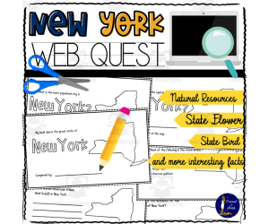
New York WebQuest Printable Book
Social Studies, Geography, Grade 4, 5, 6, 7, 8, Worksheets, Worksheets & Printables
The New York WebQuest allows students to build their own mini book and perform online research to learn about key details of New York state. This 10-page printable book prompts students to research facts such as the most populated city, state capital, state bird, bordering states, nicknames, and more. An included map lets students mark important cities and capitals. The book contains additional blank pages so students can record extra information they find interesting. Creating the mini book strengthens online research skills as students learn to use effective keywords and identify reliable information sources. Teachers can implement this versatile resource in various ways - for whole class instruction, small group work, or as an independent homework assignment. Suitable for grade 4-8 students, the New York WebQuest is an engaging way for social studies students to become more knowledgeable about their state.
Author Soumara Siddiqui
Tags New York, New York Worksheets, New York Printables, New York Book, New York Activity

Profit Incentive for Entrepreneurs Reading Packet
Social Studies, Economics, Grade 8, Worksheets & Printables, Worksheets
This resource is a Profit Incentive for Entrepreneurs Reading Packet. This is a great no prep resource that all you have to do is print and go! Students will love learning economics as they read an informative passage and apply vocabulary terms. Worksheets included such as multiple-choice questions and graphic organizers will allow them to show what they know. These work well for social studies or reading instruction. Answer keys included.
Author Sarah Miller Tech
Tags Entrepreneurs, Economics, Reading Passage, Vocabulary, Graphic Organizers

US State Study Guide Worksheets on Kansas
Social Studies, Economics, First Peoples (Native), Geography, Government, History, History: USA, Grade 7, 8, 9, 10, 11, 12, Worksheets & Printables, Worksheets
US State Study Guide Worksheets on Kansas Bring the rich history, geography, and cultural identity of Kansas to life with this US State Study Guide on Kansas —a dynamic printable teaching resource tailored for Grades 7 through 12 . Perfect for Geography , Social Studies , and US History classes, this ready-to-use 2-page PDF worksheet pack engages students with interactive, standards-aligned activities that promote state-specific learning in a meaningful, creative way. What’s Included: ✅ 2 Printable PDF Worksheets – Easy-to-print and classroom-ready, designed with clear sections and visually engaging layouts. ✅ QR Code Integration – Instantly transport your students to Kansas' geographic location on Google Maps to visually explore its position within the United States. ✅ Etymology Activity – Dive into the origin and meaning of the name “Kansas” , connecting linguistic history with cultural understanding. ✅ General State Information Task – Guide students to summarize key facts about Kansas , including nickname, motto and more. ✅ Geography-Focused Questions – Students will write down the names of the states bordering with Kansas and they will write about its climate and territory ✅ History Timeline – Includes a blank timeline for learners to research and record major historical events , from early statehood to modern milestones. ✅ Economy Exploration – This activity lets students examine Kansas’ economic sectors , such as agriculture, manufacturing, aerospace, and tech industries. ✅ Capital City Focus: writing the name of the capital city + 7 sights ✅ Top 5 Cities Activity – Learners will research and list five major cities in Kansas This Kansas US State study consists of 2 PDF printable worksheets, perfect for engaging students in grades 7th-12th as they explore the history and geography of this US State Learning with Alan is dedicated to supporting teachers, educators, and tutors in achieving their teaching goals while fostering an engaging learning environment. Learning is Fun. Never Forget! For more of my Teaching Resources, click here Learning with Alan
Author Learning with Alan
Rating
Tags Social Studies, Worksheets, Printable, Activity, Study Guide, Geography, Kansas, USA, US History, US States
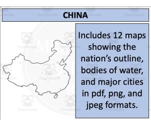
China Map Resources
Social Studies, Geography, Not Grade Specific, Worksheets & Printables, Worksheets
China Map Resources This China Map Resources is a comprehensive set of maps tailored specifically for educators in the field of Social Studies and Geography. The content comprises twelve separate map sheets available in pdf, jpeg, and png formats. Your Benefits: Variety of blank outlines for assigning tasks to students. Bodies of water and major settlements depicted clearly to aid lessons on topography or urban geography. Versions showing China among neighboring nations broadening the geopolitical understanding about the nation. This resource pack is designed with ultimate flexibility. As an educator, you may incorporate them into your classes or use them in any products you create, so long as you adhere to the guidelines outlined on the preview sheet. This China Map Resources may be used with individually, or as a set depending on how lessons or units on China are presented to the students. This China Map Resources are bundled in Zip format allowing easy download and storage. These adaptable teaching materials are perfect for varying student age groups as no specific grade level is required. - Solidify lesson plans - Enrich student understanding - Have access to globally inclusive material Pick this functional collection today: China Map Resources.
Author Mr Gray History
Tags China Maps, Geography, Social Studies, Teaching Resources, Urban Topography

Benjamin Franklin History Packet | Nonfiction Reading
Social Studies, History, History: USA, Preschool, Grade 1, 2, Worksheets & Printables, Worksheets
This resource is a Benjamin Franklin History Packet. There is a nonfiction reading passage about Franklin and students will use this passage to complete the worksheets in this packet. Students will be able to work on main idea, summarizing and so much more. Answer keys included.
Author Sarah Miller Tech
Tags Informational Texts, Graphic Organizers, Benjamin Franklin, Inventors, Biographies

Crash Course Government Episode Worksheet | 26 - Freedom of the Press
Social Studies, Government, Grade 7, 8, 9, 10, Worksheets & Printables, Worksheets
Freedom of the Press Crash Course Government Worksheet Dive into the important First Amendment right of freedom of the press with this engaging video worksheet. The informative Crash Course Government video clearly explains how freedom of the press works in America, its history, modern implications, and more. This helpful 2-page worksheet features 15 thought-provoking questions to answer while viewing the 7-minute Freedom of the Press video. Easily access the video right from the digital worksheet. An answer key is included to self-check understanding. Implement individually or in groups. Play the lively video more than once for students to make connections and solidify their learning. Use to teach key civics and government concepts regarding constitutional rights and responsibilities. Supplements social studies curriculum for grades 7-10. From the creator of popular resources like the 28th Amendment Project, Arctic Survival Activity, and more U.S. government teaching materials.
Author Ed Dynamic
Tags Crash Course, Government Videos, Political Science, Politics Video, Freedom Of The Press, U.S. Constitution, Supreme Court, First Amendment, Crash Course 26 Answers, Crash Course 26

Crash Course Psychology Episode Worksheet | 24 - Brains vs. Bias
Social Studies, History, Psychology, Grade 10, 11, 12, Worksheets & Printables, Worksheets
Crash Course Psychology Brains vs. Bias Worksheet This 2-page digital worksheet accompanies the Crash Course Psychology video "Brains vs. Bias" to engage high school students with real-world psychology concepts. With 15 comprehension questions, students will strengthen critical thinking as they analyze human biases and brain functions. An answer key allows students to check their understanding. Educators can utilize this resource in various ways: assign to individuals, small groups, or the whole class. Students can watch the 11-minute video then complete the worksheet to cement knowledge. Allowing a second viewing cements concepts. I create engaging psychology resources like this Brains vs. Bias worksheet to provide meaningful materials to high schoolers. Please browse my store for more Crash Course Psychology episode worksheets, activities like the Desert Island Simulation, and sociology resources to liven up social studies.
Author Ed Dynamic
Tags Brains Vs. Bias, Intelligence, Cognitive Development, Aptitude Test, Achievement Test, Crash Course Worksheet, Crash Course Video, Psychology Worksheet, Bias Worksheet

Ancient Rome Lapbook / Interactive Notebook - EBOOK
Social Studies, History, History: Ancient, Preschool, Grade 1, 2, 3, 4, 5, 6, 7, 8, Worksheets & Printables, Worksheets
The Ancient Rome Lapbook / Interactive Notebook - EBOOK This is a comprehensive interactive learning tool aimed at engaging students from kindergarten to 8th grade in the exploration of ancient Rome. This eBook combines a clear focus on historical content, including the daily lives of Roman citizens, gladiators, Roman soldiers' responsibilities and much more. Integrating Detailed Study Guide for Educators Included in this resource is a highly detailed study guide for educators that equips teachers with all the resources needed to effectively convey this intriguing subject. This eBook presents an adventure-filled journey into history deploying betrayal, war and rebellion as teaching strategies. 72-page Features Meticulous instructions alongside creative templates encouraging students to cut out elements ineffably bonding their learning experience with interactivity and hands-on tasks. Potential development of either a lapbook or interactive notebook sparking creativity allied seamlessly with knowledge acquisition about ancient Rome. Versatility in Implementation This resource can be utilized within whole group instruction where collaboration among peers is reinforced; small breakout groups enhancing interaction; or individual homework assignments allowing each learner to move at their speed creating room for self-paced learning that increases academic autonomy. Catered Subjects Include: Social studies largely focused on subtopics related specifically to History: Ancient which provides an excellent segue into understanding foundational events shaping our modern world today. Famous Figures from Ancient Rome Included: Romulus and Remus, Marc Anthony, Caesar, Constantine In conclusion, The Ancient Rome Lapbook / Interactive Notebook - EBOOK adds a dimension of interactivity making classroom teachings more exploitative eliciting active participation ultimately enhancing remembrance & comprehension including PDF compatibility hence digitizing learning adaptive to this technology age.
Author Knowledge Box Central
Tags Ancient Rome, Interactive Learning, Lapbook, Roman History, Social Studies

Brazil Map Resources
Social Studies, Geography, Not Grade Specific, Worksheets & Printables, Worksheets
Brazil Map Resources As educators, we are often on the lookout for reliable and relevant resources to aid in our lessons. This comprehensive set of Brazil Map Resources promises to be just that. An invaluable addition to your teaching toolbox, these materials are focused towards social studies classes with a sub-focus on geography. This product offers an extensive collection of twelve different map sheets featuring various aspects of Brazil's geographical layout. The maps are available in pdf, jpeg, and png formats, making them compatible with a wide variety of mediums – from digital displays to printable handouts Each map within this resource set serves a distinct purpose. Blank outlines provide room for student activity. The maps highlighting bodies of water or major settlements can create engaging class discussions around Brazil's geographical features or social demographics. To expand your lesson's scope beyond just one nation, the collection also includes detailed maps displaying Brazil’s geopolitical context among its neighboring countries - lending a broader perspective to students regarding regional characteristics and relationships. A specialty feature about these resources is their adaptability. As an educator you can seamlessly incorporate these maps into your own educational material while maintaining compliance with the guidelines provided in the preview sheet. Finally, this product isn’t grade-specific; it allows great flexibility when adapting it into curriculum plans from early education up through secondary level classes. In summary: The Brazil Map Resources provide comprehensive coverage linked with versatility - enabling educators like us to enhance our social studies/geography presentations and assignments effectively while facilitating engaged learning for our students.
Author Mr Gray History
Tags Brazil Map, Geography Resources, Social Studies, Educator Tools, Hands-on Learning
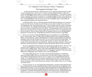
Plessy vs Ferguson Case | Comprehension Questions
Social Studies, History, History: USA, Grade 9, 10, 11, 12, Worksheets & Printables, Worksheets
This resource is a comprehension activity for U.S. Supreme Court Decision: Plessy v Ferguson: “The Separate but Equal” Case. This homework or classwork activity gives students an opportunity to learn about the landmark US Supreme Court decision Plessy v Ferguson. It works great for a flipped classroom when you want students to have the background and a general understanding of the material before you can discuss it in class. Also works great for homework or review after covering the material. This two-page sheet has all of the information that students need to know and covers the stuff that not all history books will tell you. A lot of the document consists of primary source quotes by those involved. It concludes with eight questions for students to check their understanding. A teacher answer key makes up the last page of the document.
Author DrDrew
Tags Supreme Court, U.S. History, Reading Passage, Comprehension Questions, Plessy Vs Ferguson, Plessy V.ferguson Worksheet Answers

Entertainment - Old and New
Social Studies, History, History: British, Grade 1, 2, 3, 4, Worksheets & Printables, Worksheets
Entertainment - Old and New focuses on the evolution of entertainment over time. This 9-page resource provides teachers with 8 pages of labelled images, depicting forms of entertainment like theatre, music, and games . The visuals showcase a contrast between entertainment in the past and present across topics like communication, travel, and technology. An additional activity sheet allows flexibility for students to sort images chronologically or categorically through collaborative tasks. Whether utilizing the materials for whole-class instruction, small groups, or independent work, the resource promotes critical thinking. With customization enabled through full editability, educators can adapt this versatile teaching aid to suit diverse curriculums and learner needs. Altogether, the packet integrates social studies, literacy, and visual learning standards in an engaging way for grades 1-4.
Author Elementary Resources 4 U
Tags Entertainment, Evolution, Chronology, Customization

Asian Animals Coloring Sheets.
Social Studies, Creative Arts, Grade 1, 2, 3, Worksheets & Printables, Worksheets, Coloring Pages
Get ready to embark on a colorful journey through the fascinating world of Asian animals with this printable coloring pages set. Perfect for kids, this resource offers an educational and creative activity that introduces young learners to the unique wildlife found across Asia’s diverse landscapes. Children will enjoy coloring and learning about a wide range of animals from forests, mountains, jungles, and grasslands. From the iconic Giant Panda to the elusive Snow Leopard , each illustration provides an opportunity to spark curiosity, build fine motor skills, and promote animal recognition. What You’ll Get: ✅ 55 fun and engaging animal coloring pages ✅ PDF printable file – ready to use instantly ✅ Standard 8.5 x 11" size for easy printing ✅ Cute and realistic illustrations of: Asian Elephant Giant Panda Snow Leopard Red Panda Siberian Tiger Indian Rhinoceros Asian Black Bear Malayan Tapir Sun Bear Yak Bactrian Camel Proboscis Monkey Orangutan Japanese Macaque And many more fascinating Asian animals, including birds and reptiles! Whether you're teaching about Asian ecosystems , looking for a fun educational activity, or simply exploring world animals, this resource is a perfect addition to your learning tools. Please consider leaving a review —your feedback helps other educators and parents know if this resource is the right fit for them.
Author Nena Creations
Rating
Tags Asian Animals Coloring Pages Asia Wildlife For Kids Printable Animal Worksheets Panda Tiger Coloring Educational Animal Printables Animals Of Asia Wildlife Coloring Book Biodiversity Activity Animal Habitats Resources Endangered Animals For Kids Jungle Animal Coloring Printable Panda Coloring Tiger Printable Pages Classroom Animal Activities Zoo Animal Worksheets Kids Animal Coloring Pack Asian Rainforest Animals Homeschool Animal Unit Coloring Pages For Science World Geography For Kids

Missouri WebQuest Printable Book
Social Studies, Geography, Grade 4, 5, 6, 7, 8, Worksheets, Worksheets & Printables
Product Title: Missouri WebQuest Printable Book The Missouri WebQuest Printable Book is a wonderful resource designed to engage students between the grade levels 4-8 in comprehensive online research and interactive learning. This product optimizes the use of technology in classroom settings and enhances each student's understanding of geography, with a particular focus on their home state. An Engaging Activity for Learning More About Your State Designed as an informative investigation activity , this printable book encourages students to delve deeper into the diverse facets pertaining to the state of Missouri. The book provides an ideal platform for students to bolster their web exploration skills; they will be able to identify critical terms necessary for productive online research while simultaneously fortifying their ability to discern reliable resources. Aspects Covered Within The Book The most populated city in Missouri The state capital The recognized state bird and flower The history of indigenous Native American tribes within the region An overview of notable natural resources among others. To promote further investigative curiosity there are blank spaces provided for additional information collected during research. A Chance To Showcase Creativity And Learn History Hands-On This educational tool serves as more than just an informative gateway; it utilizes creativity by asking learners not only fill out but also assemble mini books regarding West Virginia's rich history. Each page can be cut into two copies which allows flexibility for interactive creation - fostering ownership through personalized printouts that can also double up as unique keepsake souvenirs from their educational journey at school. Mapping activities included allow essential geographical insights about where major cities and capitals are sited within West Virginia. Moreover, it permits students themselves visually represent learnings via hand-drawn markings. Post-Purchase Support Provided answer keys ensure convenient corrections when needed. Reviews shared by other educators indicate swift response times from sellers – a noteworthy attribute that confirms continued support post-purchase. The Missouri WebQuest Printable Book is an experience—one that not only allows students to learn but also empowers them with the ability to communicate, create, and conduct themselves as self-guided learners. It’s an opportunity for classrooms or homeschool environments to upskill students with a fun-filled catalyst for learning, whether it be a group task, a mini project or even set as exciting homework.
Author Soumara Siddiqui
Tags Missouri, WebQuest, Printable Book, Geography, Research