2,763 products added recently
Page 68 - Social Studies Worksheets
Enhance your social studies curriculum with worksheets covering geography, history, civics, and cultures. These resources include maps, timelines, and critical thinking exercises. Use them to deepen understanding of societal structures and encourage informed citizenship.
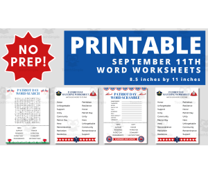
September 11 Printable Word Search Activity
Social Studies, Holiday & Seasonal, ELA, History, History: USA, Reading, Language Development, Vocabulary, Spelling, Grade 1, 2, 3, 4, Word Searches, Worksheets, Worksheets & Printables
Are you ready to have a no prep September 11 Word Search Activity activity for class? Look no further than this 4 Page Word Search. This September 11 Word Search Activity serves as an excellent tool to facilitate meaningful conversations about the events that have shaped our nation. These Worksheets Focuses on The Following Words Honor Patriot Day Unforgettable Remembrance Community Patriotism Hero Unity Resilience Support This PDF Includes 4 Labor Day Themed Worksheets Answer Key Did you know word searches can offer several benefits when used as a tool in classroom? Here are some advantages of word search activities: Engagement and Fun: Word searches can be a fun and engaging activity for young children. They may enjoy the thrill of discovery as they find each word and may not even realize they are learning in the process. Cognitive Development: Word searches engage various cognitive skills such as memory, attention, visual processing, and analytical thinking. Regularly engaging in these activities can contribute to overall cognitive development. Calm and Focused Activity : Word searches can serve as a quiet and focused activity that can help children relax and concentrate. This can be particularly useful for managing hyperactivity or for providing a constructive break from more intense activities.
Author Teacher Jenny
Tags September 11 Word Search Activity , September 11 Printable Word Search Activity, September 11 Activity, September 11 Lesson Plan, Patriot Day Word Search Activity, Patriot Day Printable Activity
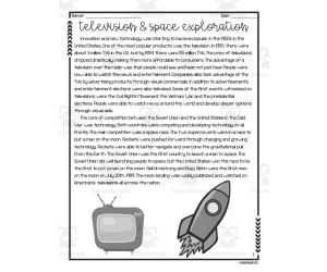
Television + Space Exploration Reading Packet
Social Studies, History, History: USA, Grade 5, Worksheets & Printables, Worksheets
Television + Space Exploration Reading Packet is an engaging social studies resource for 5th grade students to build content knowledge and reading comprehension skills. This printable packet allows flexible implementation for whole group, small group, or independent work. The informative nonfiction passage chronicles important events in the history of television and space exploration. Students will apply content vocabulary terms in context. The multiple choice questions and graphic organizers facilitate demonstration of knowledge gained from the text. Answer keys are included for teacher reference. This research-based teaching resource seamlessly integrates social studies and literacy. The grade-level appropriate text and focused skill practice encourage student comprehension and content retention. The versatile activities suit a variety of instructional approaches in both traditional and remote settings.
Author Sarah Miller Tech
Tags Space Exploration, Inventions, History, Graphic Organizers, Comprehension
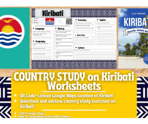
Country Study Worksheets on Kiribati - Oceania
Social Studies, Geography, First Peoples (Native), Grade 7, 8, 9, 10, 11, 12, Worksheets & Printables, Worksheets
Country Study Worksheets on Kiribati - Oceania This Geography + Social Studies Teaching Resource is a PDF Printable Worksheets Country Study Activity on Kiribati (island country in Oceania). This Printable Country Study Activity can be great for Social Studies + Geography students at Middle School and High School (from 7th grade to 12th grade) In this teaching resource on Kiribati (Country Study; Oceania), Social Studies + Geography teachers can find the following topics: Basic Geography (borders, climate), language (English and Gilbertese), history, culture, economy, Capital city (Tarawa) and other major urban centers In this Social Studies + Geography Country Study on Kiribati (island country located in Oceania), you can find the following activities and exercises: questions related to the history of Kiribati (island country in Oceania) 2 questions on the language spoken in Kiribati (English and Gilbertese) 3 questions related to the Geography of Kiribati (climate, territory and borders) 2 questions related to the Economy of Kiribati (currency and overall description) 1 activity related to the Capital City of Kiribati (writing 7 attractions of the capital city) 1 activity related to other cities in Kiribati (writing other 5 cities) 1 activity related to the culture of Kiribati Additionally, this resource includes a QR code linking to Google Maps geographical position of Kiribati (island country in Oceania) This Kiribati country study consists of 2 PDF printable worksheets, perfect for engaging students in grades 7-12 as they explore the rich history, culture, and geography of this country in Oceania Learning with Alan is dedicated to supporting teachers, educators, and tutors in achieving their teaching goals while fostering an engaging learning environment. Learning is Fun. Never Forget! For more of my Teaching Resources, click here Learning with Alan
Author Learning with Alan
Tags Social Studies, Country Study, Worksheets, Printable, Geography, Kiribati, Oceania, Activity, Island

Vehicle Words Worksheet
Social Studies, ELA, Language Development, Vocabulary, Preschool, Grade 1, 2, Worksheets & Printables, Worksheets
This Vehicle Words Worksheet is perfect for helping students match words to vehicle pictures. This is a great resource for teachers who want to help their students learn more about transportation.
Author Have Fun Teaching
Tags Have Fun Teaching

Capital + GDP in Australia Reading Packet
Social Studies, Economics, Grade 6, Worksheets & Printables, Worksheets
Capital + GDP in Australia Reading Packet is an engaging economics resource for sixth grade students. This printable packet helps learners explore key economic concepts like capital and GDP through the context of Australia. Students will read an informative passage detailing how Australia utilizes capital and measures GDP. Multiple interactive activities allow students to apply their knowledge, including multiple choice questions, graphic organizers , and short response writing prompts. Educators can implement this resource in various ways - as part of a whole class economics unit, in small groups for differentiated instruction, or as an independent homework assignment. Answer keys are provided for all activities. Overall, this concise, skill-building packet is a valuable tool for reinforcing student comprehension of capital and GDP.
Author Sarah Miller Tech
Tags Economics, Australia, Capital, GDP, Reading Passage
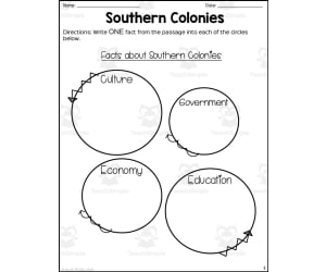
Southern Colonies Reading Packet
Social Studies, History, History: USA, Grade 3, Worksheets & Printables, Worksheets
Southern Colonies Reading Packet teaches 3rd grade students about the establishment and development of the Southern colonies in early America. Students read an informative passage detailing the cultures, economies, and societies of these colonies. They then apply key vocabulary terms and concepts through multiple choice questions, graphic organizers, and short response questions. This printable packet works well for social studies or ELA classes, in whole groups, small groups, centers , or as individual practice. With included answer keys, it requires minimal prep and provides engaging social studies content with reading comprehension and analysis practice.
Author Sarah Miller Tech
Tags Southern Colonies, History, Reading Comprehension, Graphic Organizers, Vocabulary, What Was The Education Like In The Southern Colonies, What Was Education Like In The Southern Colonies, Education In The Southern Colonies
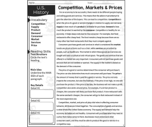
Competition, Markets + Prices Reading Packet
Social Studies, Economics, Grade 5, Worksheets & Printables, Worksheets
Competitive, Markets + Prices Reading Packet This invaluable teaching resource—The Competition, Markets and Prices Reading Packet—purpose-built for economics education ensures Grade 5 learners undertake an engaging exploration into the concepts of competition, markets, and pricing. Its approach marries easily accessible texts with practical vocabulary application. The beauty of this material lies in its 'print-and-go' scheme which promises to save educators precious time that would otherwise be spent on manual lesson preparation. Not just theory-based, this packet emphasizes on understanding through application as well. Within the packet & key features: Intriguing worksheets designed to enhance knowledge absorption process, Multiple-choice questions meant as a fun check on understanding and retention, Useful graphic organizers to visually simplify complex topics, Carefully drafted content suited for both social studies or reading instruction sessions enhancing usage versatility. An aspect setting it apart is its comprehensive content coverage. It presents 16-pages worth!, each ready-to-print and collectively covering all key points within its subject matter scope. Last but not least—a convenient 'Answer Key' section eases marking assignments or offers self-correction options during group learning activities. Possible Use Cases: This reading supplement could be put to use in various contexts: Incorporation during whole-group discussions for a class-wide instructional insight exchange. Addition to small group interactive sessions where students collaboratively share findings. Serving meaningful homework assignments that contribute extension beyond classroom lessons. *Special Mention* : As a wholly PDF based product that promises real-world topical relevance while simplifying otherwise intricate economics lessons like Competition-Markets & Prices, it stands to play a crucial role in preparing competent future economists. Recommended grade level: specific reference to Grade 5, whether for classroom instruction or homeschooling.
Author Sarah Miller Tech
Tags Competition, Markets, Prices, Economics Education, Worksheets

Country Study Research Project - Mali - Social Studies - West Africa
Social Studies, Geography, History, History: African, Grade 7, 8, 9, 10, 11, 12, Worksheets & Printables, Writing Prompts, Worksheets
Country Study Research Project - Mali - Social Studies Report - West Africa This Mali Country Study Research Project can be a perfect teacher tool box activity for your Geography and Social Studies classes, designed specifically for Middle School and High School students (Grades 7–12) . Suitable for Country Study Activities , this printable, 2-page PDF teaching resource engages learners to explore and endeepen important aspects and facts of Mali (West Africa). Use this Country Study Research Project on Mali to guide students through the process of building a comprehensive Country Study Report , while emproving their knowledge in areas such as geography, history, economy, language, and culture . Within this Mali Country Study Resource, Social Studies teachers can find the following geography activities: 🌍 Interactive Map Activity A QR code linking directly to Mali ’s location on Google Maps. 🏔️ Geography Questions Explore Mali ’s terrain, climate, and notable physical features. 📜 History Questions Investigate key events and historical figures that shaped Mali 's past. 🗣️ Language Exploration Learn about the official languages spoken in Mali : Fula (Fulfulde) + Songhai (Sonrai) + Tamasheq (Tuareg languages) + Dogon + Bozo + Senufo + Miniank + Soninke + Bobo 💼 Economy Questions Analyze Mali ’s economic system, major industries, and current challenges. 🏙️ Capital City Focus Write about 7 important sights in Mali ’s capital city, Bamako 🏘️ Other Cities Identify and write about 5 additional cities across Mali 🎭 Culture Prompt Reflect on Mali ’s unique cultural identity within the West Africa region This Social Studies, Geography Country Study on Mali (West Africa) PDF Digital Teaching Resource (2 PDF Printable Slides) is ideal for Middle School and High School students from 7th grade to 12th grade to test Mali and its Culture At Social Studies with Alan , we’re committed to providing fun, high-quality resources that help teachers inspire curiosity and global awareness in the classroom. Because learning should always be engaging and memorable . ➡️ Explore more Social Studies & Geography teaching tools by clicking here: Learning with Alan
Author Learning with Alan
Rating
Tags Country Study, Social Studies, Report, Geography, Africa, Mali, West Africa, Worksheets, Activity, History

Economic Models in Latin America Reading Packet
Social Studies, Economics, Grade 6, Worksheets & Printables, Worksheets
Economic Models in Latin America Reading Packet is an informative resource that teaches 6th grade students about the economies in Latin America. Students read a passage and apply vocabulary terms related to economic models. The reading is followed by multiple choice questions and graphic organizers that allow students to demonstrate their learning. This resource works well for social studies classes or as a non-fiction reading exercise. It can be used for whole class instruction, small group work, or as an individual assignment. Answer keys are included for the teacher. Overall, this concise and focused reading packet is a no-prep way for 6th grade teachers to help students understand economic models in an engaging way.
Author Sarah Miller Tech
Tags Vocabulary, Economic Models, Graphic Organizers, Assessment, Latin America

Country Study Research Project - Qatar - West Asia - Middle East
Social Studies, Geography, History, History: Asian, Grade 7, 8, 9, 10, 11, 12, Worksheets & Printables, Writing Prompts, Worksheets
Country Study Research Project - Qatar - Social Studies Report - West Asia - Middle East This Qatar Country Study Research Project can be an ideal teaching activity for your Geography and Social Studies classes, designed specifically for Middle School and High School students (from 7th grade to 12th grade) . Suitable for Country Study Activities , this printable, 2 page PDF teaching resource ecourages Social Studies + Geography students and learners to explore important aspects and facts of Qatar (West Asia - Middle East). This Country Study Research Project on Qatar can guide students through the process of building a comprehensive Country Study Report , while emproving their knowledge in areas such as geography, history, economy, language, and culture . Teachers and educators can find the following Geography + Social Studies activities and exercises in this Qatar Country Study Resource, Social Studies : 🌍 Interactive Map Activity A QR code linking directly to Qatar 's location on Google Maps 🏔️ Geography Questions Explore Qatar's terrain, climate, and notable physical features. 📜 History Questions Investigate key events and historical figures that have shaped Qatar 's past till nowadays 🗣️ Language Exploration Learn about the official language spoken in Qatar : Arabic 💼 Economy Questions Analyze Qatar economic system, major industries, and current challenges. 🏙️ Capital City Focus Write about 7 important sights in Qatar ’s capital city, Doha 🏘️ Other Cities Identify and write 5 additional cities across Qatar 🎭 Culture Prompt Writing about Qatar ’s unique cultural identity within the West Asian region (Middle East) This Social Studies, Geography Country Study on Qatar (West Asia - Middle East) PDF Digital Teaching Resource (2 PDF Printable Slides) is ideal for Middle School and High School students from 7th grade to 12th grade to test Qatar and its Culture At Social Studies with Alan , we’re committed to providing fun, high-quality resources that help teachers inspire curiosity and global awareness in the classroom. Because learning should always be engaging and memorable . ➡️ Explore more Social Studies & Geography teaching tools by clicking here: Learning with Alan
Author Learning with Alan
Rating
Tags Country Study, Geography, History, Social Studies, Asia, Qatar, Middle East, Arabic, Activity, Report

Hispanic Heritage Month Worksheets,Wordsearch,Word Scramble,Coloring
Social Studies, History, History: USA, Not Grade Specific, Coloring Pages, Worksheets, Worksheets & Printables
Explore the richness of Hispanic heritage with our comprehensive Hispanic Heritage Month Activity Bundle! This collection features a diverse range of engaging worksheets, including thought-provoking word searches, stimulating word scrambles, and captivating puzzles that not only entertain but also educate. Additionally, a beautifully designed coloring page provides a creative outlet for students to express themselves while celebrating Hispanic culture. With themes spanning from influential figures to cultural symbols, these activities offer a dynamic way to learn about the contributions and traditions of Hispanic communities. Whether used in classrooms or at home, this bundle provides an excellent resource for fostering cultural awareness and appreciation during Hispanic Heritage Month. Dive into a world of discovery and celebrate the vibrant tapestry of Hispanic heritage with these meticulously crafted worksheets. Each activity is thoughtfully designed to ignite curiosity, promote learning, and inspire a deeper understanding of the diverse cultures that shape our global community. (100 % Digital Download) Files included: • 1 PDF 7 Pages Ready to Print. • 7 JPG 300 DPI Features: -Large 8.5 X 11 inch. -Festive, Fun, and exciting designs. -High resolution images with thick dark lines. -Perfect for younger and older kids. Perfect Use For: -Collaborative Art Projects. -Diversity Discussions. -Art and Craft Projects. -Morning Work.
Author Funnyworksheets
Tags National, September, Month, Hispanic, Background, Heritage, Culture, Latino Americans, Hispanic Heritage, Immigrant
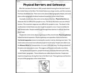
Physical Barriers and Gateways Reading Packet
Social Studies, Geography, Grade 4, Worksheets & Printables, Worksheets
This resource is a Physical Barriers and Gateways Reading Packet. This is a great no prep resource that all you have to do is print and go! Students will love learning geography as they read an informative passage and apply vocabulary terms. Worksheets included such as multiple-choice questions and graphic organizers will allow them to show what they know. These work well for social studies or reading instruction. Answer keys included.
Author Sarah Miller Tech
Tags Geography, Westward Expansion, Reading Packet, Vocabulary, Louisiana Purchase

Map Symbols Worksheet
Social Studies, Geography, Grade 1, 2, 3, 4, Worksheets & Printables, Worksheets
This Map Symbols Worksheet is a great way for students to learn and label different map symbols. By doing this, they will be able to build their map skills which will be very useful for them in the future.
Author Have Fun Teaching
Tags Maps, Geography Map Symbols

Malta Map Resources
Social Studies, Geography, Not Grade Specific, Worksheets & Printables, Worksheets
The Malta Map Resources This Malta Map Resources is an educational tool engineered specifically to enrich the social studies and geography curriculum for educators. This product boasts of its versatility and adaptability, capable of bringing light to the geographical complexities of Malta across any grade level. What You Get Six individual and intricately detailed map sheets of Malta Maps are delivered in three easy-to-use formats – pdf, jpeg, and png Maps offer a unique perspective showcasing the island nation in its pure form through blank outlines as well as detailed representations highlighting significant bodies of water and major settlements. User Convenience All contents are compressed into zip files – facilitating easy download capabilities without overburdening storage space on personal devices or cloud services. This Malta Map Resources is a ready to print and use resource. Ready to incorporate in any lesson or unit about Malta. This resource may be handed individually or as a set. Elevate Your Classroom Experience Today! Your instruction tool and guidebook across continents, oceans, cities - this resource brings world geography right within reach - enhancing teaching methods while simultaneously improving learning experiences. Unleash the understanding of socio-cultural geographies with our valuable resource: The Malta Map Resources.
Author Mr Gray History
Tags Malta Map, Geography Education, Teaching Resource, Detailed Maps, Area Studies
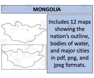
Mongolia Map Resources
Social Studies, Geography, Not Grade Specific, Worksheets & Printables, Worksheets
Mongolia Map Resources Designed for the conscientious educator incorporating geographical elements into their curriculum, The Mongolia Map Resources offers a specialized orientation towards social studies with geography as its main focus. These teaching resources are applicable to every grade level, providing versatility for different educational stages. Multifaceted Resources This package includes twelve individual map sheets available in various file formats - pdf, jpeg, and png . With the variety of formats, compatibility across multiple platforms is ensured - useful in modern classrooms or homeschool environments. From basic blank outlines to maps indicating bodies of water and major settlements; these variations capture distinct features of the Mongolian landscape. A Unique Geopolitical Perspective A standout feature of this particular product is that it portrays Mongolia not only individually but also within context—highlighting its surrounding nations. By doing this, students gain a comprehensive understanding of geopolitical relationships; broadening their world dynamics outlook. If your coverage extends beyond Mongolia's geographical bounds or if you teach U.S geography explicitly, additional resources can prove beneficial: A map resource featuring United States An expansive bundle featuring maps from 194 nations available at a significant discount— perfect for improving comprehensive geographical literacy among learners. Education has never been so geographically diverse yet so accessible!
Author Mr Gray History
Tags Mongolia Map, Geography Resources, Social Studies Aid, Lesson Planning, Geopolitical Understanding

Poland Map Resources
Social Studies, Geography, Not Grade Specific, Homeschool Resources, Worksheets & Printables, Worksheets
Poland Map Resources Designed with public school teachers and homeschoolers in mind, our Poland Map Resources is an effective educational tool. This resource comprises twelve individual map sheets, each presented in three common file formats (pdf, jpeg, and png) for convenience of use across various platforms. Blank Outlines : Perfect for testing geography knowledge or coloring exercises. Bodies of Water: Showcasing picturesque bodies of water dispersed through this Eastern European country. Majors Settlements: Featuring maps showing major settlements, conveying cultural richness and variance within the nation's borders. We also provide perspective on both Inward and Outward levels,. You will find maps showing Poland in isolation helping with memorization and recognition; other maps present Poland alongside its neighboring nations supporting discussions around geopolitics or integrated world geography lessons. Note:Certain creative use permissions are provided by following guidelines detailed in our instructions sheet accompanying these files. Select Your Desired Maps Across 194 Nations! If you wish to teach about countries worldwide beyond Europe alone, we offer similar resources related to an astounding 194 nations at a significantly reduced bundle price point that proves extremely economical over individual purchases. No Grade Limitations! Applicable across multiple grades without any specific grading limitation ensures this product’s wide usage range catering all levels where Geography forms part of teaching disciplines under Social Studies subject line mostly robustly utilized through worksheet format instructional styles across homeschooling settings or public-institution environments alike. All Files Are Delivered In Zip Format For Convenience And Quality Preservation: Compressed zip file format delivery assures hassle-free downloading while preserving optimal quality across multiple files helping easy manageability right out-the-box from download point onwards for immediate plug-n-play readiness!
Author Mr Gray History
Tags Poland Maps, Geography Resources, Lesson Planning, Homeschooling Tools, Cross-Cultural Education

State of Hawaii Spelling List
Social Studies, History, History: USA, Geography, Grade 3, 4, 5, Worksheets & Printables, Worksheets
Introducing a fun and engaging spelling list focused on building vocabulary related to the state of Hawaii. Geared towards upper elementary students, this resource features 13 essential spelling words total - 10 regular words like Hawaii, Honolulu, islands, Aloha, Pacific, Ocean, Maui, luau, Tourism, and Obama, plus 3 bonus challenge words: Pearl Harbor, Polynesia, and archipelago. The list enables students to expand their knowledge of key Hawaiian state geography terms, history references, cultural vocabulary, and famous political leaders. Implementation ideas include pre-testing students to identify unfamiliar terms, assigning the list for weekly spelling homework or warm-ups, playing vocabulary games , and more. This spelling list is a useful asset for 3rd to 5th grade elementary school teachers aiming to tie into social studies lessons on Hawaii or incorporate cross-curricular geography and history vocabulary building.
Author Mr. Matthews Teacher Store
Tags Hawaii, Vocabulary, Spelling, Geography, History, Social Studies
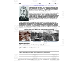
Scorched Earth Policy | Comprehension Questions
Social Studies, History, History: World, Grade 9, 10, 11, 12, Worksheets & Printables, Worksheets
This resource is a primary source analysis for Joseph Stalin's radio speech on Scorched Earth Policy in 1941. Students will read the passage and answer the comprehension questions to follow. Answer key included.
Author DrDrew
Tags Joseph Stalin, Social Studies, World History, Reading Passage, Comprehension, Stalin Scorched Earth Policy, Stalin's Scorched Earth Policy

Country Study Worksheets on Ecuador - South America
Social Studies, Geography, History, Economics, Grade 7, 8, 9, 10, 11, 12, Worksheets & Printables, Writing Prompts, Worksheets
Country Study Worksheets on Ecuador - South America This Geography + Social Studies Teaching Resource is a PDF Printable Worksheets Country Study Activity on Ecuador (Country in South America). This Printable Country Study Activity can be great for Social Studies + Geography students at Middle School and High School (from 7th grade to 12th grade) In this teaching resource on Ecuador (Country Study), Social Studies + Geography teachers can find the following topics: Basic Geography (borders, climate), languages (Spanish), history, culture, economy, Capital city (Quito) and other major urban centers In this Social Studies + Geography Country Study on Ecuador (South America), you can find the following activities and exercises: 5 questions related to the history of Ecuador 2 questions on the language spoken in Ecuador (Spanish) 3 questions related to the Geography of Ecuador (climate, territory and climate) 2 questions related to the Economy of Ecuador (currency and overall description) 1 activity related to the Capital City of Ecuador (Quito; writing 7 attractions of the capital city) 1 activity related to other cities in Ecuador (writing other 5 cities) 1 activity related to the culture of Ecuador Additionally, this resource includes a QR code linking to Google Maps geographical position of Ecuador This Ecuador country study consists of 2 PDF printable worksheets, perfect for engaging students in grades 7-12 as they explore the rich history, culture, and geography of this Country Study in South America Learning with Alan is dedicated to supporting teachers, educators, and tutors in achieving their teaching goals while fostering an engaging learning environment. Learning is Fun. Never Forget! For more of my Teaching Resources, click here Learning with Alan
Author Learning with Alan
Tags Country Study, Social Studies, Geography, Ecuador, Spanish, South America, Worksheets, Printable, Activity

Appeasement Crossword Puzzle and Word Search Packet
Social Studies, History, History: World, Grade 9, 10, 11, 12, Word Searches, Worksheets, Worksheets & Printables
This resource is an activity packet with a crossword puzzle and word search for students to complete. Students will have a reading to help them answer the questions on the crossword and word search.
Author DrDrew
Tags Appeasement, Social Studies, World History, Word Searches, Crossword Puzzles, The Cold War Word Search Answers, World War 2 Word Search Puzzle Answers

Harriet Tubman Underground Railroad Activity Packet and Worksheets
Social Studies, Biographies, Grade 1, 2, 3, 4, 5, Worksheets, Worksheets & Printables
This " Harriet Tubman Underground Railroad Activity Packet and Worksheets " is no prep required - so the packet is a quick and fun way to teach about Harriet Tubman, the Underground Railroad and black history with many printable worksheets. There are options with these activities for kids at all levels between Grades 1 and 5. Please note that not all activities in this packet will meet your class' particular levels, but there should be enough variation in the resources from your high flyers to those that are more challenged.
Author KP Classroom
Tags Tubman, Underground, Black, History, Slave, Underground Railroad Lesson Plans, Underground Railroad Worksheet Pdf, Underground Railroad Interactive Games, Underground Railroad Activity, The Underground Railroad Worksheet, Harriet Tubman Word Search
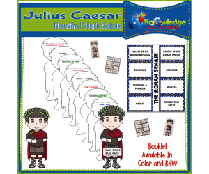
Julius Caesar Interactive Foldable Booklets – EBOOK
Social Studies, History, History: Ancient, Grade 2, 3, 4, 5, 6, 7, 8, 9, 10, 11, 12, Worksheets & Printables, Worksheets
Julius Caesar Interactive Foldable Booklets – EBOOK The Julius Caesar Interactive Foldable Booklets – EBOOK is an immersive teaching resource designed with educators in mind. Suitable for grade levels 2 through 12, this downloadable PDF enables both public school teachers and homeschoolers to introduce students to intriguing facets of ancient history, particularly the life and times of Julius Caesar. This 18-page Ebook comprises four interactive foldables that act as compact study guides. Each foldable aims to pique students' curiosity and foster a deeper understanding of the subject matter. Content Overview: Fundamental facts about Julius Caesar: The first booklet provides information about Julius Caesar, an influential military general who played a pivotal role in the demise of the Roman Republic and rise of the Roman Empire. This historical context is complemented by black & white as well as full-color versions for visual engagement. The workings of the Roman Senate: Another foldable devoted to comprehending this key political entity during Caesar's era. Once again, black & white and colorful options present information in varied modes appealing to diverse learning styles. This product offers flexible adaptation for varied teaching scenarios whether you're conducting whole-group instruction or facilitating small-group discussions thanks to its electronic format. Teachers can also assign it as independent homework or develop it into an interactive project involving crafting lapbooks to boost hands-on learning. Note: Instructions are user-friendly-"students simply cut, fold, glue before they dive into creating their personalized booklets that aid memory recall while encouraging active participation." This resource brings classrooms closer to understanding ancient Rome’s intricate socio-political landscape as part of your social studies curriculum under 'History: Ancient'. Let's make revisiting history educational and fun-engaging. Our Aim: To turn your lessons on Julius Caesar imperative while nurturing informed learners—one booklet at a time!
Author Knowledge Box Central
Tags Julius Caesar, Interactive, Foldable Booklets, Ancient Rome, Roman Empire

Notre Dame Cathedral Dot-to-Dot PDF
Math, Social Studies, Creative Arts, Middle School, Elementary, Homeschool Resources, Worksheets & Printables, Worksheets, Dot To Dots
Connect all the dots in the Notre Dame de Paris Extreme Difficulty Dot-to-Dot / Connect the Dots PDF activity! Follow the dots to reveal the medieval architectural marvel. The puzzle contains 542 dots to connect, and is a unique and rewarding activity for anyone who enjoys famous places and cathedrals. Dot-to-dots such as this one are a relaxing activity that can both educate and entertain kids. These fun puzzles can help improve fine motor skills, and also help kids develop patience and focus. Finally, they’re fun to color too! Let the kids grab some crayons or colored pencils and put a personal touch on their dot-to-dot. This Notre Dame dot-to-dot printable created by Tim van de Vall and is copyright Tim’s Printables LLC. Terms of use: May be printed/downloaded for personal and educational purposes only. The Notre Dame connect the dots is activity on page 1, and the answer key is on page 2. The page dimensions are: 8.5”x11”. PDF format.
Author Tim's Printables
Rating
Tags Notre Dame, Cathedral, Medieval, Europe, France, Dot To Dot, Connecting The Dots, Connect The Dots, Activity, Printable

Australia and Oceania Map Scavenger Hunt Bundle
Social Studies, Geography, Grade 7, 8, 9, 10, 11, 12, Worksheets & Printables, Worksheets
This informative 21-page Australia and Oceania Map Scavenger Hunt Bundle assists students in learning geography by having them locate key details on maps. Students will answer questions about major landforms, bodies of water, cities, capitals, national parks, and surrounding countries in Australia, New Zealand, Oceania, and Papua New Guinea. The bundle includes four separate map scavenger hunts that challenge students to carefully examine maps to find answers. As a supplementary social studies resource, this concise bundle helps reinforce map reading skills and expands geographic knowledge through active engagement. With multiple countries covered, it works well for individual practice or collaborative group work. The engaging map activities can be flexibly used as in-class practice, group projects , or independent homework.
Author Mr. Matthews Teacher Store
Tags Geography, Map Skills, Oceania, Australia, New Zealand, Papua New Guinea