24 related resources

Namibia Map Resources – 12 Printable Map Sheets

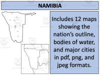
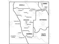
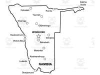
Twelve map sheets show Namibia four ways — towns alone, towns with the Okavango and Chobe rivers, towns with Angola, Zambia and Botswana named, and rivers and neighbours together — with unlabelled versions of the same outline alongside.
Grades
Not Grade Specific
File type
Multiple File Types

Updated Sep 05, 2023

Subject
Social Studies, Geography
Topic
Namibia, Geography
Resource types
Worksheets & Printables, Worksheets

About this resource

What's inside this resource

Product: Namibia Map Resources

Overview:

This teaching resource comes with an expansive collection of twelve unique map sheets presented in different formats, such as PDF, JPEG, and PNG. These various versions portray Namibia from multiple perspectives to enrich your class's understanding of its geographical condition.

Product Details:

  • Every map sheet included in the kit illustrates diverse aspects of Namibia. There are blank outlines offering a basic framework - excellent for tests and quizzes or independent research projects.

  • You'll also find maps delineating bodies of water for a closer look at the country’s fluvial system along with visual depictions that highlight significant settlements boosting your students' knowledge about the population distribution across this African nation.

  • Additionally, there is a series of maps where Namibia is shown both in isolation and connection to its neighboring countries. This gives learners a clearer idea about its geopolitical context within Africa - perfect for lessons on regional relations by exploring how borders interact or influence natural resources distribution.

The resource kit allows buyers to incorporate these purchased map images into their own work following specific instructions available on the preview sheet.

Optional Extras:

The package also provides a link where users can access additional resources like a free downloadable map of the United States among others. For extended study beyond Africa, you may consider availing another bundle that includes significant data on 194 different nations available at an attractive discount.

Suitable Grade Level & Subject Area Usage:

These materials are designed not to be grade-specific but flexible enough to be integrated into various educational levels – from elementary classes grasping basic geographic concepts to high school students diving into more complex topics.

It caters primarily to instruction within Social Studies and specifically underpins Geography lessons by providing reliable visual aids highlighting spatial representation alongside cultural or socio-political influences affecting areas covered by these maps.

File Format & Type:

The arrayed worksheets come packaged in Zip format which means they can conveniently be downloaded simultaneously saving time spent accessing each file separately.

In the classroom

Teaching tips & learning objectives

Learning objectives

  • Locate Namibia's capital, Windhoek, and place it against the coastal towns of Walvis Bay, Swakopmund and Lüderitz

  • Name the countries bordering Namibia to the north and east — Angola, Zambia and Botswana

  • Identify the rivers marked along Namibia's northern edge, including the Okavango, the Chobe and the Zambezi

  • Distinguish Namibia's coastal settlements from its inland ones using the spread of the fifteen named places

Teaching tips

  • The labelled and unlabelled versions of the same outline are supplied together, so one can be projected while students work on the other

  • Four levels of detail are available on the identical outline, which lets a single map be reused as a lesson moves from the country alone to its rivers and then to its neighbours

  • The individual PNG and JPEG files carry the same twelve maps as the PDF, so a map can be placed on a slide or a task sheet without exporting a page first

  • Windhoek is set in capitals while the other fourteen towns are not, which gives students a visual cue for the capital before any labelling is done

  • The maps carry no printed questions or directions, so the task around them — labelling, colouring, comparing, testing — is set by the teacher

Skills covered

  • Map reading — students read a country outline that carries fifteen named settlements and locate each one against the coast, the borders and the capital.

  • Regional orientation — the versions naming Angola, Zambia and Botswana place Namibia inside southern Africa rather than showing it in isolation.

  • Physical geography — the river maps mark the Okavango, Chobe and Zambezi along the northern edge, separating water features from settlement.

  • Working from a blank outline — the unlabelled sheets carry the same borders without any printed names, so students can add features themselves.

  • Classroom map preparation — teachers pick the level of detail a lesson needs from four labelled versions of one outline and print or project it.

Good to know

Questions teachers ask about this resource

How do the twelve maps differ from one another?

Four of them carry printed labels and eight do not. The labelled four build up in layers on the same outline: towns alone; towns with the Okavango and Chobe rivers; towns with Angola, Zambia and Botswana named across the borders; and a final version carrying rivers and neighbours together, with the Zambezi added.

Which places are named on the labelled maps?

Fifteen. Windhoek is set in capitals in the centre. Walvis Bay, Swakopmund, Lüderitz and Oranjemund run down the coast; Oshakati, Rundu, Katima Mulilo and Tsumeb sit across the north; and Khorixas, Otjiwarongo, Gobabis, Rehoboth, Mariental and Keetmanshoop fill the interior and the south.

Does the set show Namibia on its own or in its regional setting?

Both, on the same outline. Two of the labelled maps show Namibia alone with its towns and rivers; the other two name Angola to the north, Zambia to the north-east and Botswana to the east. The same base map therefore serves a single-country study and a southern Africa lesson without a change of projection or scale.

No reviews yet

Downloaded this resource? Tell other teachers how it went.

Resource details

Concepts & topics

Core concepts

  • Namibia

  • Map skills

  • Physical geography

  • Africa

Explore more

Categories this resource belongs to

Explore related searches

More to explore

You may also like