



Search results for Maps
Results use exact search terms from the released Canada inventory.


Compass Rose Worksheet
, Not Grade Specific,
Compass Rose Worksheet asks learners to place all eight direction abbreviations on a compass diagram. North, south, east, and west establish the four cardinal points, while northeast, southeast, northwest, and southwest complete the diagonal positions. The single labelling task keeps attention on the spatial arrangement and abbreviation of each direction. Every required abbreviation is printed in the direction line for reference during completion.
Author Have Fun Teaching
Rating
Tags Maps, Compass Rose Printable, Compass Activity Worksheet, How To Use A Compass Worksheet, Compass Worksheet, Compass Rose Simple
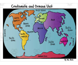
Continents and Oceans Map Lesson with Song and Facts
, Not Grade Specific,
A fifty-slide geography presentation teaches the seven continents, world oceans, and cardinal directions through a motion song and continent-by-continent fact stops, several tied to external video links.
Author Super Teacher Tactics
Rating
Tags Geography Education, Seven Continents, Map Navigation, Cardinal Directions, Culturally Diverse

Continents Worksheet - Countries
, Not Grade Specific,
Ten country names drawn from several world regions prompt students to write the continent for each. An atlas or comparable geographic resource is explicitly encouraged, turning the exercise into guided reference use rather than unsupported recall. The completed second page allows teachers to check all placements after the geographic search.
Author Have Fun Teaching
Rating
Tags Maps

Coordinate Grid Map Location – Plotting Worksheet
, Not Grade Specific,
Create a map-location activity with this blank grid labelled A–J horizontally and 0–10 vertically. Students can add places and exchange letter-number location clues. The single printable page includes name and title spaces; supply your own map-making instructions.
Author Have Fun Teaching
Rating
Tags Sight Words, Maps, Blank Grid Map, Map With Coordinate Grid, Coordinate Grid Map, Map Grid Worksheets Pdf, Coordinate Grid Worksheets

Find the Parts of a Map Worksheet
, Not Grade Specific,
Map Elements guides students through observing an actual map rather than memorizing isolated definitions. Separate sections name the title, legend, cardinal directions, and scale, with prompts to record what each element shows and how it supports map use. Learners can work from a classroom map, atlas page, or teacher-selected example. The repeated question structure encourages functional explanations, such as how a legend decodes symbols or a scale connects map distance with real distance.
Author Have Fun Teaching
Rating
Tags Maps, Parts Of A Map, Map Elements, Geography Skills, Map Reading, Label Parts Of A Map Worksheet, 5 Parts Of A Map, What Are The Parts Of A Map

Finding a Spot on a Map Worksheet
, Not Grade Specific,
The single page is headed as a map-location activity and gives a direct instruction to write coordinates for town places shown on the visual map. Learners must pair the map’s grid references with the labelled locations rather than plotting new points from a list. This supports systematic horizontal-and-vertical lookup in a practical town context. The task centres on locating existing places rather than plotting new points or drawing a route across the town.
Author Have Fun Teaching
Rating
Tags Graphing, Maps
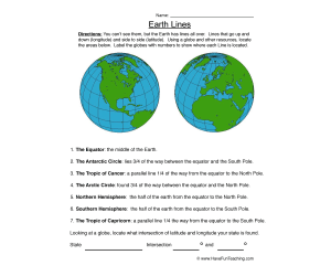
Labelling Latitude and Longitude Worksheet
, Not Grade Specific,
The page introduces invisible Earth lines by contrasting vertical longitude with horizontal latitude. Seven named regions or parallels are located and numbered on globe illustrations, including the equator, hemispheres, circles, and tropics. A coordinate extension asks learners to use the intersection of latitude and longitude to identify locations. The combined task develops both global reference vocabulary and the practical idea that two coordinates pinpoint a place.
Author Have Fun Teaching
Rating
Tags Maps, Longitude And Latitude Worksheet, Latitude And Longitude Worksheet, Latitude Longitude Worksheet, World Latitude And Longitude Worksheets

Map Symbols Worksheet – Label & Identify
, Not Grade Specific,
Maps communicate location through small pictures, and this page asks learners to reason about what several unlabeled symbols could mean. Each illustration receives a student-created map label rather than being matched to a fixed bank. A final open prompt invites an original symbol, extending recognition into visual design. The activity supports discussion about why a useful symbol must be simple, distinctive, and understandable to another map reader.
Author Have Fun Teaching
Rating
Tags Maps, Geography Map Symbols
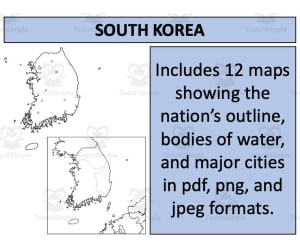
South Korea Maps: Twelve Printable Designs
, Not Grade Specific,
Explore South Korean cities, rivers and neighbouring countries with twelve map designs. Labelled and blank options come in PDF, PNG and JPEG formats.
Author Mr Gray History
Rating
Tags

United States Outline Maps: Colour and Black-and-White
, Not Grade Specific,
Use two US state-outline maps for a teacher-planned geography activity. The maps do not label states, capitals, routes or districts.
Author educ_project
Rating
Tags

United Arab Emirates Maps: Six Designs
, Not Grade Specific,
Locate UAE cities and bodies of water on labelled maps, or choose a blank outline for your own task. Six map designs come in PDF, PNG and JPEG formats.
Author Mr Gray History
Rating
Tags