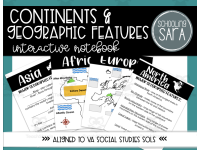
Continents, Oceans, and Geography Interactive Notebook


About This Product
This product covers the 2015 Virginia (VA) Standards of Learning (SOL) 3.6 The student will develop map skills by using globes and maps to locate and describe major rivers, mountain ranges, and other geographic features of
a) Africa;
b) Asia;
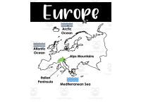
c) Europe;
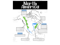
d) North America; and
e) South America.
(note that this will also work for the 2023 VA SOL 3.2 The student will apply history and social science skills to locate and describe major geographic features of the seven continents Africa, Antarctica, Asia, Australia, Europe, North America, and South America by a) locating and describing the seven continents and the five oceans; and b) locating and describing the equator, the Prime Meridian, and the four hemispheres. AND VA SOL 3.3 The student will apply history and social science skills to describe major geographic features of ancient societies on a world map by a) identifying and locating major bodies of water; b) identifying and locating major mountain ranges;)
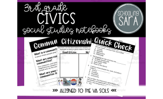
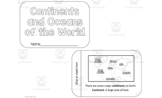
This notebook has notes pages on the following topics: the seven continents, the five oceans, and the seven continents and five oceans combined. It also includes the compass rose, cardinal directions, intermediate directions, and key latitude and longitude vocabulary - including the Equator and Prime Meridian. It also has notes pages on hemispheres.
Included in this product are two sizes of notes pages: a full page size and a notebook size. For the first size, you can print them as-is to put in binders or large notebooks or to use as worksheets. You can also print the full page ones 2-to-a-sheet. This saves paper, and these half sheets fit in both a spiral and composition notebook. The second set is sized to fit in a standard composition notebook and will also fit a spiral notebook.
Additionally, there are two links included in the pdf: one which opens a digital version of the notes, and another that opens a slide show version, optimized for a projector or interactive board. In both cases, which you click the link, you will be prompted to make a copy, which you can then use with Google Slides or download and use with Keynote or PowerPoint.
Resource Tags
0 Reviews
Check out these other great products