World Map Activity – Countries & Continents Lesson


Attributes
Subject
Types
File
Editable
No
Rating
Add To Collection
About This Product
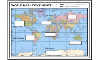
The Countries & Continents - World Map Activity teaching resource is a PowerPoint designed to boost students' geographic knowledge. The 8-slide presentation lists countries from around the world for students to locate on their print or digital atlases. Learners must then determine which continent each country resides within. This fun challenge allows students to apply their understanding of country locations and continent boundaries in a low-prep activity suitable for whole group, small group, or independent practice. With answers provided, it's easy for teachers to facilitate and assess student learning. Fully editable for customization, this world map activity helps to expand students' understanding of geography in an easy-to-implement format that works for grade 1 through 4 classrooms. The concise, editable presentation targets essential map skills through active learning.
Resource Tags
0 Reviews
Explore related searches
you may also like...
Check out these other great products

Worksheets & Printables, Worksheets
Worksheets, Worksheets & Printables

Worksheets & Printables, Worksheets

Free Download
Worksheets & Printables, Worksheets, Teacher Tools, Crosswords Puzzles, Centers, Activities