2,751 products added recently
Page 79 - Social Studies Worksheets
Enhance your social studies curriculum with worksheets covering geography, history, civics, and cultures. These resources include maps, timelines, and critical thinking exercises. Use them to deepen understanding of societal structures and encourage informed citizenship.

Spelling List: Chile
Social Studies, ELA, Geography, Language Development, Spelling, Grade 4, 5, 6, 7, Teacher Tools, Assessments, Worksheets & Printables, Worksheets
Spelling List: Chile This Spelling List: Chile is an educational resource designed to enrich lexical knowledge in Grade 4, 5, 6 and 7 learners targeting Social Studies and Language Arts curricula. Engaging Approach to Vocabulary Expansion This product features a list of words linked contextually to Chile. It emphasizes on practical learning with detailed breakdowns including syllabification, phonetic spellings as well as pronunciation guides. List of Words: Santiago Valparaíso Concepción Mestizo Bonus Word: Marraqueta Please note there are seven other primary words along with two more bonus vocabulary. A separate page compiles profound definitions of all thirteen aforementioned geographical vocabulary. This descriptive glossary not only bolsters individual lexicon development but also presents interesting facts about the South American country Chile. Versatile Application Across Various Classroom Settings The "Spelling List: Chile" is perfect for use in whole group instruction scenarios or small group activities. It can also be customized for homeschool lesson plans or assigned routinely at home for self-revision purposes. Comes downloadable as an easily accessible four-paged PDF document. The 'Spelling List: Chile' serves not just as a spelling list but an enriching journey mapping its way across linguistic terrains to the geographical landscapes of Chile. It is a ready to use resource!
Author Mr. Matthews Teacher Store
Tags Chile Spelling, Vocabulary Expansion, Geographic Terms, Language Arts, Social Studies
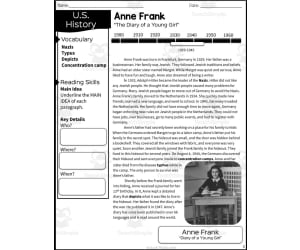
Anne Frank Reading Packet
Social Studies, History, History: World, Grade 4, 5, Worksheets & Printables, Worksheets
The Anne Frank Reading Packet is an informative resource for upper elementary students to learn about Anne Frank and the Holocaust. Students will read a passage detailing Anne's life leading up to and during her time in hiding. Following the reading, students will demonstrate comprehension through multiple choice questions and graphic organizers focused on sequencing key events, identifying vocabulary terms, and making text-to-self connections. This packet works well for whole class, small group, or independent work in either the social studies classroom or during reading instruction. As a printable PDF, it requires no prep and provides an engaging way for grade 4-5 students to build background knowledge on Anne Frank and familiarize themselves with this important time period in history. Answer keys are included to support teachers in assessing student understanding. Overall, an excellent resource for upper elementary classrooms to introduce the courageous story of Anne Frank.
Author Sarah Miller Tech
Tags Reading Packet, World History, Anne Frank, Exit Ticket, Graphic Organizers

Geography: Countries Bordering Austria
Social Studies, Geography, Grade 1, 2, 3, 4, Worksheets & Printables, Worksheets
Geography: Countries Bordering Austria Resource The Geography: Countries Bordering Austria resource is a short yet information-dense digital booklet specially designed for young learners in Grades 1-4. It serves as a beneficial study tool for both public school educators and homeschoolers. This educational material primarily focuses on Austria's geographic details. Some of the key topics covered include identifying Austria's neighboring countries, getting familiar with its capital city - Vienna, and learning about prominent physical features like the River Danube. The booklet also extends to activities that can be done in the stunning Austrian Alps, providing comprehensive knowledge of this Central European country. Highlights of the Resource: Efficient identification and recalling of Austria's border countries. Familiarity with Vienna - its renowned capital city. In-depth understanding of prominent natural attractions like the River Danube and Austrian Alps. Versatility: The booklet proves to be extremely versatile when it comes to usage. It can be effectively utilized as part of whole group instruction or for smaller more focused learning groups. This makes it adaptable based on teaching strategies or specific scenario requirements . For independent studies, have your pupils use this for their homework tasks! Editability & Accessibility: A significant advantage is its editable interface that allows easy customization based on specific learning outcomes or varied complexity levels. Available in Zip file format ensures universal accessibility across different devices further ensuring adaptability even during remote teaching instances Note: Be sure to incorporate Geography: Countries Bordering Austria into your curriculum today! This hands-on interactive tool not only piques students' interest but also effectively nurtures their global comprehension skills - a necessity for developing geography enthusiasts!
Author Elementary Resources 4 U
Tags Geography, Austria, Bordering Countries, Capital City, Danube River

Iowa State Symbols Interactive Foldable Booklets - EBOOK
Social Studies, Geography, Preschool, Grade 1, 2, 3, 4, 5, 6, 7, 8, Worksheets & Printables, Worksheets
Iowa State Symbols Interactive Foldable Booklets eBook The Iowa State Symbols Interactive Foldable Booklets eBook is an engaging resource designed for K-8 educators focusing on teaching the state symbols of Iowa. This comprehensive tool offers a captivating method to introduce or review topics such as the state's map, flag, flower, bird and notable mammals/insects/fish. The interactive booklet is available in two variations: Fully colored version, A black and white variant that doubles as a coloring activity. Educational Application This versatile teaching material can be incorporated across various educational capacities: Whole class projects, Inquiry-led independent or group work, An engaging alternative to regular homework assignments. Add-On Features Additional features include: An extra blank page for adding personal insights, A page with links to useful research sites related to Iowa’s information. There's also accessibility of similar eBooks about other states within this series – further broadening the scope of geography studies across all grade levels. Download Details and Format The downloading process is straightforward producing a print-friendly PDF file for effortless preparation making social studies instruction both memorable and enjoyable using innovative resources like Iowa State Symbols Interactive Foldable Booklets eBook."
Author Knowledge Box Central
Tags Iowa, State Symbols, Interactive, Foldable Booklets, Learning

Crash Course Government Episode Worksheet | 27 - Search and Seizure
Social Studies, Government, Grade 7, 8, 9, 10, Worksheets & Printables, Worksheets
Crash Course Government Episode Worksheet | 27 - Search and Seizure This 2-page worksheet accompanies the 7-minute Crash Course Government video on search and seizure. It includes 15 questions for students to answer while watching the engaging video, which is linked at the top of the worksheet for easy access. An answer key is provided to allow students to check their own work. To implement, print the worksheet and allow students to watch the video and answer questions individually or in small groups, depending on availability of devices. Replay as needed to reinforce understanding of this key government topic. Pair with other politics and government resources like lectures on civil rights and Constitutional clauses. Products utilize videos and activities to help middle and high school students actively engage with history and government content. Check the store for additional Crash Course episode worksheets and complementary resources for a comprehensive curriculum .
Author Ed Dynamic
Tags Search And Seizure, Government Lesson, Politics, Political Science Videos, Crash Course, Comprehension Questions, U.S. Constitution, Civil Liberties

Navajo Code Talkers | Fill in the Blank Worksheet
Social Studies, History, History: USA, Grade 7, 8, 9, 10, 11, 12, Worksheets & Printables, Worksheets
This resource is a Navajo Code Talkers activity . Students will complete the 10 fill in the blank sentences. They will use those words to find in the word scramble. Answer key included.
Author DrDrew
Tags Navajo, Social Studies, Fill In The Blank, History Worksheet, Complete Sentences, Navajo Code Talkers Lesson Plans, Navajo Code Talkers Worksheet Pdf
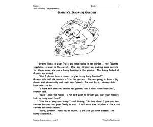
Granny's Growing Garden Reading Comprehension Worksheet
Social Studies, ELA, Biographies, Science, Earth and Environmental Sciences, Earth Sciences, Reading, Special Resources, Life Skills, Grade 1, 2, 3, Worksheets & Printables, Worksheets
This Granny's Growing Garden - Reading Comprehension Worksheet is a great way for your students to build their reading comprehension skills. The worksheet includes questions about the story that will help teachers gauge their students' understanding.
Author Have Fun Teaching
Tags Plants, Reading Comprehension, Family

Country Study Research Project - Samoa - Oceania
Social Studies, First Peoples (Native), Geography, History, Grade 7, 8, 9, 10, 11, 12, Worksheets & Printables, Writing Prompts, Worksheets
Country Study Research Project - Samoa - Social Studies Report - Oceania This Samoa Country Study Research Project can be an ideal teaching activity for your Geography and Social Studies classes, designed specifically for Middle School and High School students (from 7th grade to 12th grade) . Suitable for Country Study Activities , this printable, 2 page PDF teaching resource ecourages Social Studies + Geography students and learners to explore important aspects and facts of Samoa (Oceania - Pacific Ocean). This Country Study Research Project on Samoa can guide students through the process of building a comprehensive Country Study Report , while emproving their knowledge in areas such as geography, history, economy, language, and culture . Teachers and educators can find the following Geography + Social Studies activities and exercises in this Samoa Country Study Resource, Social Studies : 🌍 Interactive Map Activity A QR code linking directly to Samoa 's location on Google Maps 🏔️ Geography Questions Explore Samoa's terrain, climate, and notable physical features. 📜 History Questions Investigate key events and historical figures that have shaped Samoa 's past till nowadays 🗣️ Language Exploration Learn about the official language spoken in Samoa : English + Samoan 💼 Economy Questions Analyze Samoa economic system, major industries, and current challenges. 🏙️ Capital City Focus Write about 7 important sights in Samoa ’s capital city, Apia 🏘️ Other Cities Identify and write 5 additional cities across Samoa 🎭 Culture Prompt Writing about Samoa ’s unique cultural identity within the region (Oceania - Pacific Ocean) This Social Studies, Geography Country Study on Samoa (Oceania - Pacific Ocean) PDF Digital Teaching Resource (2 PDF Printable Slides) is ideal for Middle School and High School students from 7th grade to 12th grade to test Samoa and its Culture At Social Studies with Alan , we’re committed to providing fun, high-quality resources that help teachers inspire curiosity and global awareness in the classroom. Because learning should always be engaging and memorable . ➡️ Explore more Social Studies & Geography teaching tools by clicking here: Learning with Alan
Author Learning with Alan
Rating
Tags Country Study, Social Studies, Report, Research, Geography, History, Oceania, Samoa, Activity, Printable

War of 1812 Reading Packet - 5th Grade TEKS
Social Studies, History, History: USA, Grade 5, Worksheets & Printables, Worksheets
The War of 1812 Reading Packet teaches 5th grade students about this important time period in U.S. history. Students read an informative passage detailing key events and figures from the War of 1812. To support comprehension, context clues and a vocabulary bank define relevant terms. After reading, students demonstrate understanding by completing multiple choice questions, graphic organizers , and short response questions. Teachers can implement this packet during social studies instruction, guided reading groups, or independent practice. The reading passage, practice questions, graphic organizers , and answer keys are provided in this printable PDF packet. This resource aligns to 5th grade TEKS standards for social studies and covers people, events, and motivations behind the War of 1812.
Author Sarah Miller Tech
Tags War Of 1812, Reading Comprehension, Graphic Organizers, U.S. History, Cause And Effect, The War Of 1812 Worksheet Answers, The War Of 1812 Worksheet
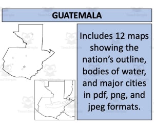
Guatemala Map Resources
Social Studies, Geography, Not Grade Specific, Worksheets & Printables, Worksheets
Guatemala Map Resources The Guatemala Map Resources is a remarkable teaching tool, particularly curated for educators in the field of social studies and geography. This multifaceted resource boasts of a variety of maps, each with unique features capable of facilitating diverse aspects when discussing Guatemalan geography. This comprehensive package omits grade-specific limitations – making it accessible to educators from all levels. Instructors can incorporate this versatile toolkit into their curriculum dynamically to facilitate discussions on geographical themes. Formats and Interactivity: The package spans twelve unique map sheets available in formats like PDF, JPEG, and PNG. The interactive blank outlines encourage direct student involvement during lessons as an engaging educational activity or quiz. Focus on Geographic Relations: The entire set not only emphasizes Guatemala's isolation but also shed light on its geographic relationships with neighboring territories. This makes it an excellent choice for discussing international borders or geopolitical concepts. To summarize, this Guatemala Map Resources is not just worksheets but rather serves as a complete atlas packed tightly into one zip file format focusing explicitly on Guatemala. It transforms geography lessons from mere classroom discussions into dynamic journeys across nations. These Guatemala Map Resources is a ready to print and use resource!
Author Mr Gray History
Tags Guatemala, Geography Teaching, Map Resources, Interactive Learning, Country Study

Lakes of USA Map
Social Studies, Geography, Grade 3, 4, 5, Worksheets & Printables, Worksheets
The Lakes of the USA Map allows students to locate and label 14 major lakes across the United States. This engaging social studies resource first presents a map with the lakes numbered. Students then match the lake numbers to a second page that lists the lake names. They write the corresponding name on the numbered lines of the blank map. Through this activity, learners reinforce geography knowledge and spatial relationships of important US lakes. Use the reproducible PDF as individual seatwork, a small group activity, or a whole class assessment . The Lake Map suits various instructional approaches for 3rd-5th grade public or home school. Students gain confidence navigating US geography while educators check comprehension levels. By completing the map, students cement knowledge about lake locations for long-term retention.
Author TheBrightestKid
Tags Map, Lakes, United States, Location Of Lakes, Usa Map Lakes, Map Of Usa With Lakes

Marie Van Brittan Brown Interactive Foldable Booklets – EBOOK
Social Studies, History, History: USA, Grade 2, 3, 4, 5, 6, 7, 8, 9, 10, 11, 12, Worksheets & Printables, Worksheets
Discover the life of Marie Van Brittan Brown as you create these interactive foldables for your Interactive Notebook or Lapbook. These 2 foldables cover: *Basic facts about Marie Van Brittan Brown *Home Security System This ebook format includes a downloadable PDF file. Just follow the instructions, cut, fold, glue, and create! Keywords: Mary Van Brittan Brown, Inventor, Invention, Patent, Home Security System, Black History, African American, Interactive, Foldable, Amy Moses Check out all of our Black History Interactive Foldable Booklets: Alexander Miles Alice Walker Birmingham Campaign Booker T. Washington Dr. Patricia Bath Dorothy Vaughan Elijah McCoy Emancipation Proclamation Frederick Douglass George Washington Carver Harriet Tubman James Baldwin Jim Crow Laws Jan Ernst Matzeliger Jackie Robinson Katherine Johnson Langston Hughes Lewis Latimer Little Rock Nine Maya Angelou Mary Jackson Martin Luther King, Jr March on Washington Marie Van Britton Brown Octavia Butler Phillis Wheatley Richard Wright Ralph Waldo Ellison Sarah Breedlove Walker Sarah E. Goode Sojourner Truth Thurgood Marshall Terry McMillan Toni Morrison Zora Neale Hurston
Author Knowledge Box Central
Tags Mary Van Brittan Brown, Inventor, Inventions, Black History, African American, What Was Marie Van Brittan Brown Favorite Color, Mary Van Brittan Brown, Marie Van Brittan Brown Invention Facts, Mary Van Brittan, Marie Van Brittan Brown Facts, Brittan Brown, Marie Van Brittan Brown Life, Marie Brittan Brown, Mary Van Brittan Brown., Marie Van Brittan Brown Early Life, Facts About Marie Van Brittan Brown
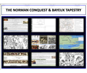
Bayeux Tapestry
Social Studies, History, History: Europe, Grade 9, 10, 11, 12, Worksheets & Printables, Worksheets
Bayeux Tapestry The Bayeux Tapestry teaching resource is a comprehensive material designed specifically for educators who seek to teach students about the significant historical event of the Norman conquest of England. This product facilitates strong connections between past and present, taking students on an engaging journey through time. It’s ideal for 9th to 12th-grade students studying European history under Social Studies. What's Included? Reading Sheets: Our packet begins with several reading sheets providing detailed content about the context and events surrounding the Norman Conquest of England. Map and Poster Project Sheets: These allow hands-on learning experiences. Students engage in map work, plotting crucial locations related to the Norman Conquest while fostering their spatial thinking skills. Annotated Bayeux Tapestry: A core strength of this teaching resource lies within this segment where detailed descriptions accompany each section of this pivotal piece of medieval artwork making student understand its contents deeply. Coloring Pages: To add some fun into history lessons, we've got coloring pages showcasing different sections from the tapestry that helps visualize these historical episodes vividly. A PowerPoint Presentation: To wrap up this package we offer a PowerPoint presentation effectively integrating textual information with visual elements allowing educators seamless delivery during class or online instruction needs as well. Bonus Resources In addition, links have been provided focusing on additional topics like "Early Middle Ages," "Later Middle Ages," "Castles," plus "Knights & Medieval Warfare" these are perfect supplements for full coverage over medieval history topic plans Note: The file type available for download is Zip - it's effortless to access using any standard programs or free software readily available online. This set provides an all-encompassing package that allows you effortlessly bring history alive!
Author Mr Gray History
Tags Bayeux Tapestry, Norman Conquest, Medieval History, Hands-on Learning, European History

Reading assignments: First explorers
Social Studies, History, History: Canada, Grade 3, 4, 5, 6, Worksheets & Printables, Worksheets
TABLE OF CONTENTS p.4 Making predictions p.5 Prior knowledge p.6 Text with illustrations p.7 Reading strategies p.8-9 Questions p.10-11 Answer key p.12 Making connections p.13 Opinion about the text p.14 Favorite passage p.15 Transforming p.16 Cliparts credits
Author Learn it ANY way
Tags Explorers, Canada Exploration, Exploration, Sailboart, Reading

Cowboys Interactive Foldable Booklets - EBOOK
Social Studies, History, History: USA, Grade 1, 2, 3, 4, 5, 6, 7, 8, 9, 10, 11, 12, Worksheets & Printables, Worksheets
Explore the history of Cowboys as you create these interactive foldables for your Interactive Notebook or Lapbook These 2 foldables cover: *Cowboys of the old west *Life and work on a ranch This ebook format includes a downloadable PDF file. Just follow the instructions, cut, fold, glue, and create! Keywords: Cowboys, Horses, Old West, Western, Cows, Cattle, Rodeo, Ranch, Westward Expansion, Interactive, Foldable, Amy Moses Check out all of our Westward Expansion Interactive Foldable Booklets: Annie Oakley Battle of the Alamo Cowboys California Gold Rush Lewis and Clark Louisiana Purchase Mexican American War Oregon Trail Pony Express Pioneer Life Sacagawea Sam Houston Transcontinental Railroad Trail of Tears
Author Knowledge Box Central
Tags Cowboys, Westward Expansion, Ranch, Old West
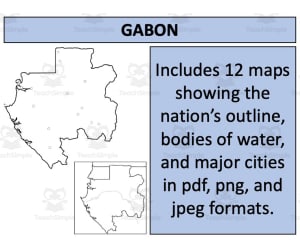
Gabon Map Resources
Social Studies, Geography, Not Grade Specific, Worksheets & Printables, Worksheets
Gabon Map Resources A practical teaching tool designed to aid social studies educators. These Gabon Map Resources come with twelve unique map sheets for geography lessons specifically about Gabon and its neighboring countries. Available in three different formats: PDF, JPEG, and PNG, tailored to be usable across various digital platforms. Makes it an ideal choice for display in classrooms or as reference material for students in a public school or homeschooling environment. Diverse Geographical Aspects Blank outlines : A useful practice tool for gaining a better understanding of the region's topography. Bodies of water maps: Depicts significant aquatic landmarks that influence Gabon's landscape and climate conditions. Settlements maps: This resource caters key human geographical factors such as population density, urbanization trends or historical aspects related to Gabon. The individual benefits of each map combined provide comprehensive geographical knowledge about Gabon. This collection doesn't limit itself with just imparting raw data but offers a meaningful analytical depth on the nation's distinctive geographical identity. Geared towards meeting diverse learning needs without grade-specific restrictions along with an uncomplicated accessibility (provided as ZIP file), this Gabon Map Resources simply elevates geography lessons! Have your students learn about Gabon with this additional Gabon Map Resources!
Author Mr Gray History
Tags Gabon, Geography Resources, Map Sheets, Teaching Tools, Human Geography

Sri Lanka Map Resources
Social Studies, Geography, Not Grade Specific, Worksheets & Printables, Worksheets
Sri Lanka Map Resources Presenting a comprehensive pack of twelve individual map sheets in easily accessible pdf, jpeg, and png formats. This collection is a vital resource for educators and homeschoolers prepared to explore the complex geography of Sri Lanka. Detailed Map Renditions The map set boasts meticulously detailed renditions featuring blank outlines alongside bodies of water and significant settlements. These maps ensure your learners grasp each socio-geographical aspect adequately. Furthermore, they offer an opportunity to show where Sri Lanka positions itself on the global stage with its neighbouring nations. Versatility Across Learning Stages This product promotes versatility throughout all learning stages - from elementary-level comprehension extending up to high school's in-depth analysis requirements. As educators, these resources can be effectively used while teaching various subjects under Social Studies. In Geography: these maps become useful tools in visualizing geographical data or explaining historical influences shaping present-day borders within Sri Lanka's context. *Provided in Zip File format* Gather all essential elements together for easy access whenever required via a convenient Zip file format! Also, you have freedom to creatively use them into your teaching framework as long as instructions provided on the preview sheet are adhered to. The Power of Visual Aids in Learning Dive right into creating engaging discussions about global geography with this valuable asset! The Sri Lanka Map Resources breathe life into your teaching methods by optimising visual aids allowing better assimilation of knowledge amongst students.
Author Mr Gray History
Tags Sri Lanka, Map Resources, Geography Education, Social Studies, Historical Borders

America The Story of Us: Video Viewing Guide & Questions | Episode 3 • WESTWARD
Social Studies, History, History: USA, Grade 5, 6, 7, 8, 9, 10, 11, 12, Worksheets & Printables, Worksheets
America Story of Us, by the History Channel, is one of the best video series to show for any American or US History class. Teachers love the quality content, and students enjoy the engaging visuals! Certainly considered a classic by now, this series has 12 episodes ranging from the early setters of Jamestown, all the way through September 11th and the new millennium. This viewing guide for episode 3 entitled "Westward" includes the following information: Trailblazing pioneers head west on the Oregon Trail and Mormon Trail Frontier adventurers like Daniel Boone explore the Appalachians Lewis and Clark expedition and the exploration of the Louisiana Purchase Sacajawea helps Lewis and Clark California gold rush The steamboat creates a new wave of industry and transportation Mountain men like Jedediah Smith blaze trails through the Rocky Mountains The Alamo, Texas, and Davy Crockett The Cherokee and the Trail of Tears What's Included: All questions for this product are for the viewing of Episode 3 • Westward. There are over 20 thoughtful questions that are presented in the order of the video. All questions are completely editable if you prefer to alter any questions. Questions are separated into labeled, time-stamped viewing segments for students to easily follow along. Each worksheet also ends with one thought provoking question to stimulate classroom discussion. Answer keys are included for all questions. Worksheets are available in a Google Classroom format for students to complete on any device. These worksheets can also be easily exported as a stunning PDF for students to complete as a double sided worksheet . (Whether you have a student that needs special assistance, or you prefer your class to have a paper format, this printable PDF option is extremely helpful for any classroom.) Whichever format you prefer, both options will look and feel the same for easy grading by you the teacher
Author Mister Harms
Tags Oregon Trail, American History, Westward, Pioneers, Government, America: The Story Of Us Westward Part 2

2nd Grade Reading Packet: Positive Citizenship Traits in History
Social Studies, History, History: USA, Grade 2, Worksheets & Printables, Worksheets
The 2nd Grade Reading Packet: Positive Citizenship Traits in History provides students an engaging way to build citizenship and reading skills. This printable packet has an informative passage spotlighting model citizens like Rosa Parks. Using context clues, students will learn vocabulary about positive character traits. Multiple choice questions, graphic organizers , and short writing prompts give students practice identifying main ideas, supporting details, sequencing events, and making text-to-self connections. Teachers can use this packet for independent practice, small group instruction, or whole class reading lessons to help meet 2nd grade social studies and literacy standards. Answer keys are included to support instruction and remediation. This versatile resource works for in-class learning or at-home practice.
Author Sarah Miller Tech
Tags Traits, Citizenship, History, Cross-curricular, Comprehension
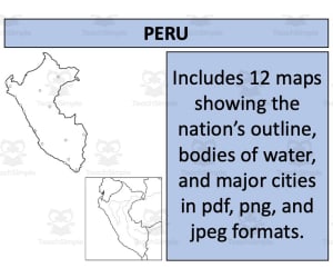
Peru Map Resources
Social Studies, Geography, Not Grade Specific, Worksheets & Printables, Worksheets
Product: Peru Map Resources This set of Peru Map clipart resources comprises twelve distinct map sheets, designed meticulously to facilitate diverse educational needs. Designed for versatile use across grade levels, the resource caters to social studies, particularly focusing on geography. The maps featured in this pack come in various formats including pdf, jpeg and png. This flexibility ensures that you can easily incorporate the maps into different mediums of instruction with ease. Included within these collections are blank outlines that offer room for interactive learning where students can fill in details or color code sections. The collection also includes detailed segments that display bodies of water and major settlements which bring an advanced level of detail into your lessons. A unique feature about this resource is that it portrays Peru in two distinct contexts - isolated and as part of surrounding nations. This dual-level approach facilitates understanding both at a micro and macro level. It helps study regional dynamics while permitting focused attention on individual state specifics. If you wish more variety or broader coverage beyond one nation-state locus, we offer an attractively priced bundle featuring detailed geographical information on 194 different nations. Ready-to-download Zip Files: The resources come as easy-to-manage zip files ensuring smooth downloads without any interruptions; never before has map-focused teaching been so effortless!
Author Mr Gray History
Tags Peru Map, Educational Resources, Social Studies, Geography Teaching, Map Clipart

Massachusetts Word Search Worksheet
Social Studies, History, History: USA, Grade 1, 2, 3, 4, 5, 6, Word Searches, Worksheets, Worksheets & Printables
This Massachusetts Word Search Worksheet is a great way to help your students learn important vocabulary words related to the state of Massachusetts. This resource is perfect for teachers who are looking for a fun and engaging way to teach their students about different states.
Author Have Fun Teaching
Tags States

Nebraska WebQuest Printable Book
Social Studies, Geography, Grade 4, 5, 6, 7, 8, Worksheets, Worksheets & Printables
Nebraska WebQuest Printable Book An engaging, interactive teaching resource designed for students in grades 4-8, Nebraska WebQuest Printable Book nurtures students' skills in research, interpretation and comprehension while enhancing their knowledge about the state of Nebraska. Key Features: Rooted in Social Studies coursework with a specific focus on Geography Filled with hands-on activities like marking city's capitals and researching intriguing information online Incorporates activities such as finding the official state bird or flower, identifying popular nicknames and locating natural resources found within the state boundaries Promotes active learning and boosts digital literacy through guided webquests. This product is part academic research project, part treasure hunt; as students fill out each page based on guided WebQuests (online-based directed searches), they will not only learn but also create a keepsake record of their newfound knowledge. Versatility: Can be implemented across whole groups during classroom instructions or even small breakout sessions where discourse can inspire more individualized interpretations. Sporting an empty page dedicated to capturing additional details that didn't fit neatly into predefined categories! Bonus for Educators: An intuitive design - once printed (with two copies per single printout included), these pages can easily be sliced down the center line followed by stacking up methodically stapled together. Also comes along with a comprehensive answer key ensuring accurate fact-checking anytime during your teaching journey. Educational Impact: With Nebraska WebQuest Printable Book ensure multi-faceted development for your young learners as they explore intricacies tied to a place fundamental to their daily lives while honing generic yet pivotal skills like research and analysis. Nebraska WebQuest Printable Book - it's more than just an activity , it’s a journey of discovery.
Author Soumara Siddiqui
Tags Nebraska, WebQuest, Printable Book, Geography, Research

Nevada WebQuest Printable Book
Social Studies, Geography, Grade 4, 5, 6, 7, 8, Worksheets, Worksheets & Printables
The Nevada WebQuest Printable Book: A unique exploration tool tailored for educators and students in grades 4-8. This compact and portable mini-book, is perfect for field trips or nature walks. Its interactive design encourages active learning as students are prompted to research facts online about Nevada. The mini-book comprises of: 10 pages with engaging tasks that include identifying: Nevada's most populated city Capital city State symbol such as its bird and flower Historical content regarding native tribes that lived in Nevada. Geographical information regarding bordering states & natural resources in the area. In addition there are blank spaces intended for documenting captivating facts discovered during the research journey. Each print yields two identical pages – simply cut along the dotted lines and stack separately allowing each student to create their own travel booklet at ease. This resource can be used both collectively, leading to class-wide presentations or discussions and independently serving as an excellent practice tool to enhance research skills over time. Note: The design simplicity ensures even those new to online research can make use of this resource. The package includes an answer key providing immediate support when needed. The “Nevada WebQuest Printable Book” promises strengthened geography insights via virtual field trips right from your classroom's walls! It beautifully combines knowledge acquisition with adventure catering specifically to our young explorers' curiosity.
Author Soumara Siddiqui
Tags Nevada, WebQuest, Printable Book, Active Learning, Research Skills

Wyoming Word Search Worksheet
Social Studies, History, History: USA, Grade 1, 2, 3, 4, 5, 6, Word Searches, Worksheets, Worksheets & Printables
This Wyoming Word Search Worksheet is a great way to help your students learn important vocabulary words related to the state of Wyoming. This worksheet is a great resource for teachers who want to help their students learn more about Wyoming.
Author Have Fun Teaching
Tags States