Charlemagne Empire Map – Historical European Boundaries


Attributes
Subject
Grades
Types
File
Editable
No
Rating
Add To Collection
About This Product
Charlemagne Empire Historical Maps: An Exceptional Teaching Resource
Overview:These educational maps serve as an invaluable resource for public school teachers and homeschooling parents keen on exploring the complex annals of European history. They cover historically significant events over several centuries, facilitating in-depth learning of key historical happenings.
This offering is non-grade specific, fitting a wide range of learners making it a flexible tool for educators teaching students of different age groups or levels. These visually appealing maps make Social Studies more interactive by allowing students to virtually experience the historical context.
- Each set features line art and colored graphics that aid in understanding intricate timelines and geopolitical transformations.
- The topics covered include:
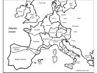
- Charlemagne's empire:Kick light on one Europe's most significant monarchs,
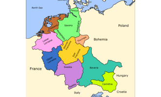
- Germany during the 10th-11th centuries:Evidencing its pivotal role in shaping contemporary Europe,
- Europe circa 1000AD:Demonstrating how tribal communities evolved into systematic kingdoms.
- In addition, these sets also highlight essential aspects like:
- Gothic migrations and kingdoms during late antiquity, establishing their relevance in forming medieval history,
- The Norman Conquest emphasizing William I's epic influence over British culture, The Anglo-Saxons:
User-friendly PDF files offer teachers ease-of-use while incorporating these maps into diverse lesson plans. These could be group activities where learners study historical patterns collectively or individual tasks where pupils critically evaluate salient events denoted on maps.
Final Thoughts: In essence, this remarkable teaching tool is much more than just a compilation of historical maps. It affords an interactive medium to animate crucial points of European history within learning environments. By driving spatial thinking via visual aids–these instructional assets enable students to build a profound understanding of how past worldwide occurrences shaped the world we currently inhabit, thereby enhancing their overall grasp over social studies.
What's Included
This set includes line art and colored graphics
Resource Tags
0 Reviews
Explore related searches
you may also like...
Check out these other great products

Worksheets & Printables, Worksheets

Worksheets & Printables, Worksheets
