Hungary Map Resources


About This Product
Hungary Map Resources
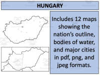
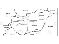
Meet the Hungary Map Resources, a comprehensive set of geographic resources tailored for educators at all grade levels. Within this product, you'll find twelve separate map sheets presented in three different file formats:
PDF
JPEG
PNG
These maps depict Hungary's geographical features inclusive of:
Blank outlines representing territorial boundaries,
Bodies of water indicating key river systems and major lakes prevalent in the country,
Bold representation of significant settlements across Hungary.
The flexibility offered by this representation makes it an ideal tool whether you are discussing domestic policy issues within Hungary or broader European geopolitics.
Note: You can use these maps directly within your educational products so long as you adhere to guidelines outlined on the preview sheet included with each purchase.
All educators, whether school teachers or homeschoolers who are equally invested can take advantage. Your international social studies topics will never be bland nor generic with such great add-ons readily available!
Versatile and User-friendly Worksheets!
You can seamlessly integrate these visuals into module planning due to their versatility - they're applicable in a range of educative scenarios from pop quizzes through to descriptive assessments. So go ahead and make your lessons more engaging and rewarding with Hungary Map Resources today!
Resource Tags
0 Reviews
Check out these other great products