Maps of the Globe : Earth From Space


About This Product
Product Description:
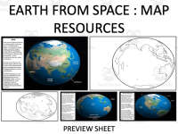
Maps of the Globe: Earth From Space is designed to be an incredibly adaptable tool for educators teaching geography and social studies. This singular resource offers a comprehensive collection of maps that outline each continent and ocean on our planet, providing a clear understanding of their relative sizes and positions in the world.
Content Overview:
- The content extends beyond what is traditionally seen in typical mapping presentations. Instead of usual mercator projections, these globe maps display the earth as it appears from space, giving students an authentic representation of our world.
- This perspective allows comprehensive knowledge acquisition about continents' actual sizes, their locations, and how they correspond with each other.
Versatility In Teaching:
This resource can be utilized in a variety of teaching scenarios for different group sizes. It can enhance whole-class lessons on global geography or small group activities. Additionally, printable versions could work as home assignments supporting independent study.
Ready-To-Print Feature:
- A notable feature is its ready-to-print structure which ensures easy implementation into any lesson plan providing both colored and blank versions which cater to varied instructional needs.
- In an interactive activity students can color blank maps themselves or use colored ones as reference - strengthening visual retention about geographical locales.
Digital Content Type:
Beyond printed formats this product provides .png and .jpeg files which integrate into digital documents for online teaching or creating custom worksheets/quizzes etc. A PDF version ensures universal accessibility for printing requirements while the .pptx file gives educators an option to edit specifying their classroom objectives.
Overall:
In conclusion, Maps of the Globe: Earth From Space is a streamlined solution tailored for effective delivery while teaching earthly geography. A solid addition into any educator's toolbox irrespective of the grade levels they're involved with!
What's Included
Maps are provided in blank and color versions. You can use the .png and .jpeg versions to easily insert the maps into a variety of different documents. The file also contains a pdf version for printing and a .pptx version so you can make any edits you wish.
Resource Tags
0 Reviews
Check out these other great products