Mauritania Map Resources


About This Product
Mauritania Map Resources
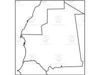
Mauritania Map Resources is a comprehensive set of pedagogical tools, perfect for both school environments and homeschooling. This resource comprises twelve individual maps in easily downloadable JPEG, PDF, and PNG file formats.
Inclusions:
Variations of Mauritania's map to enrich Geography lessons.
Blank map outlines for labeling or coloring.
Detailed maps showcasing bodies of water and significant settlements.
Mauritania's geographical positioning amidst neighboring nations.
Fulfilling more than just teaching needs – these maps can be used within your own products by following the usage guidelines detailed in our preview sheet. Further enhancing the variety of end products you can create with this versatile toolkit at your disposal.
This Mauritania Map Resources doesn't limit itself to any specific grade levels proving suitable across different educational stages - making it an invaluable asset for Worksheets type format that offers rich geography-related content. This Mauritania Map Resources is ready to print and use to complement any lesson or unit related to Mauritania.
In conclusion, the Mauritania Map Resources melds adjustability with effectiveness - proving itself an indispensable tool on your educational journey. Get ready to enhance engaging Geography sessions guided effortlessly by these professionally designed resources!
For similar or other resources, visit my store here!
0 Reviews
Check out these other great products