World Geographical Concepts and Activities


About This Product
Put your classroom atlas sets, old social studies text books or devices to good use. The students will be completely engaged in this fun independent activity.
This activity packet will help solidify student's understanding of maps and basic geographical terms in a world where they rely on technology instead of this amazing skill! The packet includes:
-A pre-test assessing basic geographical term knowledge
-A blank compass rose
-A hierarchy of geographical locations
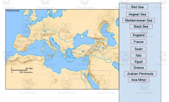
-A blank map and word bank for oceans and continents
-A blank map of the US and bodies of water
-Instructions for different labeling and shading of the US map
-Differentiated understanding of Washington state and Washington DC
-Awareness of Alaska and Hawaii as states outside of the continental US
-A blank map and word bank for Canadian territories
-Geographical/globe terms map including prime meridian, hemispheres, latitude, longitude and equator
-A world map and popular city/country naming activity
Can be done whole group, small group, individually. Use as review, preview or just for fun!
Great for end of the year activities, back to school, after state testing work and more. Model alongside the students to strengthen your understanding. It can also be chunked to fit different needs of students.
What's Included
A student packet and answer keys are included
Resource Tags
0 Reviews
Check out these other great products