United Arab Emirates Maps: Six Designs

- Year groups
- Years 4–7 (Key Stages 2–3)
- File type
- ZIP archive


- Subject
- Geography, Social Studies
- Resource types
- Worksheets
From the author
About this resource
UAE Map Resources – Versatile Teaching Materials for Geography Lessons
This educational resource provides an assembly of flexible and adaptable map materials, focusing on the United Arab Emirates (UAE). Suitable for all types of teaching environments, these visual aids are ideal to enhance lessons about geography and global awareness.
The UAE Map Resources package includes:
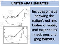
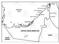
Six unique maps
Availability in pdf, jpeg, png formats
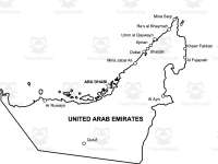
Varying designs including blank outlines for exercises/tests and informative charts displaying water bodies and major settlements
The set is designed to exhibit the UAE independently as well as its geographical context amongst neighbouring countries. These maps serve diverse purposes from improving understanding of spatial placement by tracing routes to location recognition by plotting cities. Additionally, identification exercises relating to natural resources such as water bodies serve a dual purpose in teaching about the region’s geography.
The use-case scenarios extend beyond regular geographical learning - these resources can also be harnessed during discussions about current events or history lessons revolving around Middle Eastern studies too.
Related resources
More resources teachers may find useful
More resources on the same subject and topic.


In the classroom
Teaching tips & learning objectives

Learning objectives
- Locate selected UAE cities and surrounding waters using labelled maps
- Transfer selected place labels onto an outline map

Teaching tips
- Use the unlabelled outline versions as blank maps for pupils to label, and the fully labelled map as the reference to check against.
- Drop the PNG or JPEG versions straight into slide decks or your own worksheets — one image file exists for every map.
- Pair the detailed map with a Middle East unit: it shows the UAE's position on the Persian Gulf and Strait of Hormuz beside Saudi Arabia, Oman, and Qatar.

Skills covered
- Map reading — the labelled maps place UAE cities, ports, neighbouring countries, and surrounding waters for pupils to locate and compare.
- Regional geography — the set situates the UAE within the Arabian Peninsula alongside the Persian Gulf and Strait of Hormuz.

No reviews yet
Downloaded this resource? Tell other teachers how it went.
Resource details
Core concepts
Core concepts
 Core concepts
- United Arab Emirates
- Middle East geography
- Political maps
Explore more
Categories this resource belongs to
Explore related searches



More to explore