2,792 products added recently
Page 633 - Newest Teaching Resources

Country Study on Germany Snakes and Ladders Board Game PDF Printable
Social Studies, Geography, History, History: Europe, Grade 7, 8, 9, 10, 11, 12, Worksheets, Worksheets & Printables
Country Study on Germany Snakes and Ladders Board Game PDF Printable This Teaching Resource is a PDF Board game (Snakes and Ladders; 3 slides) on Germany (Europe). This Printable Resource can be great for Geography, European History and Social Studies Classes. Suitable Learners for this kind of lesson are students from 7th Grade to 12th Grade. This Geography + Social Studies game on Germany (country Study) aims to test learners on their knowledge on Germany and German Culture (naming 4 German cities, telling about history events, telling about your pawn's character, telling about 6 Famous German individuals or telling what you would like to visit in Germany). Some preparation on Germany, German Culture and History can be useful for this Social Studies Activity. Within this amazing Country Study on Germany (Europe) board game (snakes and ladders; 3 PDF Printable slides) it is offered: 1 board with questions and Speaking Prompts (ex. name 4 German Cities or telling about German history events such as the Fall of the Berlin Wall or the Gutenberg Bible etc) 1 Printable Craft Die with numbers written 1 Printable Craft cone to make Game Pawns to play 5 Famous People from Germany such as (Johann Sebastian Bach, Martin Luther, Immanuel Kant, Ludwig van Beethoven, etc.) to stick on the players' printable craft cone This amazing and fun Social Studies + Geography Country Study on Germany (Europe) PDF Digital Teaching Resource (3 PDF Printable Slides) can be great for learners from 7th grade to 12th grade to test Germany and its Culture. Learning with Alan is a Brand New Teaching Resource, Educational Material Store whose aim is to help Teachers, Educators and Tutors to achieve their teaching objectives while creating a fun and stimulating environment. Never Forget! If you want to browse more of my Teaching Resources, click here Learning with Alan
Author Learning with Alan
Tags Europe, Geography, Social Studies, Snakes And Ladders, Germany, German Culture, Culture, Printable, Game, PDF

Country Study on Germany - Research Project + Cards + Worksheets
Social Studies, Geography, History, History: Europe, Research, Grade 7, 8, 9, 10, 11, 12, Projects, Activities
Country Study on Germany - Research Project + Cards + Worksheets This Teaching Resource is a PDF research project (10 Slides) on Germany. This Printable Resource can be great for Geography, European History and Social Studies Classes. Suitable Learners for this kind of lesson are students from 7th Grade to 12th Grade. This Geography + Social Studies Research Project on Germany (country Study) aims to make learners discover Germany (history, geography, economy, Berlin and culture). Little preparation can be helpful. Within this Country Study on Germany Research Project, it is offered: 2 worksheets to write research outcomes 64 Cards to fish for this Research Project on Germany How does this Country Study on Germany Teaching Resource work? learners (or groups) fish a Research Topic card of each color (black for history, blue for geography, orange for economy, Red for Berlin and green for German Culture) each student or group makes their personalized Research on Germany, by focusing on their fished topic cards (ex. fished black card on history on "Gutenberg Bible", blue card on geography on "the Rhine River", orange card on economy on "Tertiary Sector", Red Cards on Berlin on the Brandenburg Gate and a green card on German Culture on Immanuel Kant) Learners stick their fished cards on their research worksheet and write their Research outcomes Learners make a presentation on their personalized rersearch on Germany teacher evaluates research given learner or group's research outcomes written on worksheets Why is this Teaching Resource worth using? By fishing topic cards, students have a chance to: make unique randomized research projects focus on specific topics only and discover more the research country in "non-superficial" ways Connect their own Research outcomes with their peers' This Social Studies + Geography Country Study on Germany PDF Printable Research Project on Germany Teaching (10 slides) can be great for learners from 7th grade to 12th grade to introduce Germany and its Culture. Learning with Alan is a Brand New Teaching Resource/Educational Material Store whose aim is to help Teachers, Educators and Tutors to achieve their teaching objectives while creating a fun and stimulating environment. Never Forget! If you want to browse more of my Teaching Resources, click here Learning with Alan!
Author Learning with Alan
Tags Germany, Country Study, Research Project, Europe, European History, Geography, Research, Social Studies, Printable, Worksheet
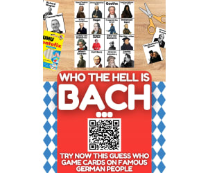
Country Study on Germany - Guess Who Game on famous German People
Social Studies, Geography, History, History: Europe, Grade 6, 7, 8, 9, 10, 11, 12, Activities, Games
Country Study on Germany - Guess Who Game on famous German People This Teaching Resource is an fun Guess Who Game PDF Presentation (1 slide, 20 cards) on Famous German People. This Printable Resource can be great for Geography, European History and Social Studies Classes. Suitable Learners for this kind of lesson are students from 6th Grade to 12th Grade. This Geography + Social Studies Guess Who Game on Famous People from Germany (Country Study) aims to introduce learners to Germany and its most famous people (leaders, kings, philosophers, writers etc.). Little Preparation is needed for this Social Studies + Geography Activity. Some of the German People selected for this Geography + Social Studies + European History Country Study on Germany are: the Brothers Grimm Thomas Mann Richard Wagner Johannes Brahms Johann Sebastian Bach Goethe Gottfried Wilhelm con Leibnitz Arthur Schopenhauer Hegel Immanuel Kant Ludwig van Beethoven Otto von Bismarck Angela Merkel Martin Luther and many more! a very fun and engaging way to play this "Guess Who on Famous People from Germany" (country study on Germany) game can be the following: all Learners sit on the floor in a circle every Learner has a Flash Card on their face every Learner/player asks a question about their Flash Card 's famous German character This Social Studies + Geography Country Study on Germany PDF Printable Teaching Resource (1 slide, 20 cards for 20 Famous People from Germany) can be great for learners from 6th grade to 12th grade to introduce Germany and its Culture through its most important and celebrated people. Learning with Alan is a Brand New Teaching Resource/Educational Material Store whose aim is to help Teachers, Educators and Tutors to achieve their teaching objectives while creating a fun and stimulating environment. Never Forget! If you want to browse more of my Teaching Resources, click here Learning with Alan!
Author Learning with Alan
Tags Germany, Europe, European History, Social Studies, Geography, Printable, Cards, Guess Who, Culture, Game

Word Games with Puzzles | Crossword Wordsearch Anagram | PHARMACY
P.E. & Health, Special Resources, ELA, Health, Special Education Needs (SEN), Speech Therapy, Life Skills, Language Development, ESL, Writing, Handwriting, Vocabulary, Not Grade Specific, Crosswords Puzzles, Worksheets, Worksheets & Printables
Word Games with Puzzles | Crossword Wordsearch Anagram | PHARMACY . Designed for usage across multiple grade levels, this teaching resource known as 'Word Games with Puzzles' seamlessly integrates essential vocabulary study with an engaging cleaning theme . This resource is incredibly versatile and adaptable to fit a variety of learning environments . It invites educators in public schools, or even those that teach in a homeschooling setting, to invigorate their Language Arts curriculum while catering to educational trends including Special Education Needs (SEN), Speech Therapy, ESL instruction, and Life Skills lessons . The primary contents of the package comprise : Anagrams centered around key terms relevant to PHARMACY such as pill, vaccine, syrup etc. Copy words crossword puzzles that provide ample opportunity for learners to expand their vocabulary while indulging in interactive gameplay . The product also offers blank and lined writing boards perfect for handwriting practice . In addition, A word matching game ideal for reviewing new words picked up during the lesson or activity session . A wheel chart bundled within serves as an excellent tool for quick reference or review sessions conducted in small groups or one-on-one tutorial arrangements . A word search board challenges pupils further by letting them identify key keywords hidden amongst many irrelevant ones - offering both challenge and fun . Supplemental Materials include: Real photos along with whimsical illustrations serve dual purposes; they function not only as flashcards but also allow teachers to create visual folders thus adding versatility and creativity into everyday teaching circumstances . All elements included can double down both as part of your center 's resources library or can be handed out on individual bases hence serving multiple needs, from group-works to homework assignments . This brings you the valued flexibility everyone appreciates when it comes down classroom management - making this product extremely well-rounded. 11 page PDF file .
Author WORDS ASIDE
Tags Vocabulary Study, Interactive Gameplay, Handwriting Practice, Word Search, Visual Aids, Word Wall, Crossword, Esl, Independent Work, Words Aside
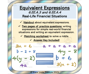
Equivalent Expressions: Handout, Financial Situations, Matching
Life Studies, Finance, Home Economics, Math, Algebra, Money, Common Core, Grade 6, 7, 8, Worksheets & Printables, Worksheets
Here's a ready to go lesson to target 6th grade math expressions and equations standards 6EE.A.3 and 6EE.A.4 1) First there is a simple and clear handout that explains to students what equivalent expressions are. There are sample equivalent expressions included and explanations of how to make them using different math techniques (combining like terms, adding and subtracting integers, using the distributive property, and finding a common factor). 2) Next, there are two pages of real life financial scenarios that students need to write equivalent expressions for. For example: "Ryan gets a $25 allowance each week and can earn $5 each time he empties the dishwasher." This could be represented by 25 + 5d which students could then factor to be 5(5 + d). 3) Finally, there is a matching worksheet with two columns of expressions. Students have to match the equivalent ones to solve a very corny riddle. I would assign this for homework after the lesson. Grades to Use With: This lesson is designed for students in 6th grade math classes to target Common Core State Standards in the 6th grade curriculum . It could also be used as a review in grades 7 and 8 or in high school special education classrooms. If you enjoy this algebra activity, check out others in my store. I always strive to show students how the math they are learning about at school is helpful in everyday life! Middle School Math Stations or Centers: Early Algebra: Patterns, Expressions, Tables, Graphing, and Equations Pre-Algebra Problem: The Wave Pool: Expressions, Tables and Graphing Algebra: Modelling Equations: Visual Balance Scale Worksheet Exponent Board Game: A Fun Way to Practice Math Skills Independent and Dependent Variables in Grade 6 Math: Hockey Math Systems of Equations: Real-World Algebra Problems Using Substitution Writing and Solving Two Step Equations from Real Life Situations
Author Grace Under Pressure
Tags Expressions, Equivalent Expressions, Algebra, 6th Grade Math, Grade 6 Math, Financial Literacy, Expressions And Equations, Equivalent, Early Algebra
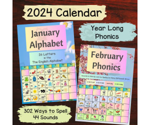
Printable Calendar 2024 for Teachers and Homeschoolers Phonics Program
ELA, Language Development, Phonics, Spelling, Preschool, Grade 1, 2, Worksheets, Worksheets & Printables
This printable phonics learning calendar for kids is designed to teach the 44 sounds of the English language and features words and pictures to easily teach 302 different letter combinations. Each sound in the English language can be represented by numerous letter combinations, which can be confusing when learning how to spell. This calendar breaks down this complex learning process to small chunks and help children to easily learn a new spelling per day! Key Features: Comprehensive Phonics Coverage: Covering all 44 sounds of the English language, this calendar provides a structured approach to spelling mastery. Visual Aid: Each day features a phonics word accompanied by a clear and relatable picture, aiding visual recognition and understanding. Printable Format: Conveniently printable, the calendar can be hung on the wall or kept on a desk for daily reference. Suitable for Classrooms, Home Learning Space, Child’s Bedroom or Family Room: the bright and cheery nature helps to make spelling a happy and natural process. Teach 44 Sounds of the English Language 10 short and long vowel sounds: a, e, i, o, u, ai, ee, igh, oa, you 10 other vowels: ar, er, ir, air, ear, oo (as in moon), oo (as in book), oi, ow, schwa 24 consonants: b, c, d, f, g, h, j, l, m, n, p, r, s, t, v, w, y, z, ch, ng, sh, th (soft), th (hard), zh More About Clever Speller Clever Speller embeds systematic and analytic phonics in natural purpose written settings to provide the context for phonics to make sense and easily show how sounds in words can be spelled in many different ways. Learning to spell words in the English language can be very confusing for children as there are so many ways to spell each sound. Our mission is to take the confusion out of this process and make learning to spell a happy time for all.
Author Clever Speller
Tags Teacher Calendar, Calendar For Kids, Phonics Program, Year Long Phonics, Visual Learning, Printable Calendar, Digital Download, 44 Sounds Of English Language, Teacher Planner

ESL Reading Comprehension Worksheet - EFL Activity on Books
ELA, Language Development, ESL, Reading, Writing, Grade 7, 8, 9, 10, 11, 12, Worksheets & Printables, Worksheets
ESL Reading Comprehension Worksheet - EFL Activity on Books This Fantastic ESL-EFL-TESOL Reading Comprehension + Writing Activity Worksheet on Reading Books and the Benefits of Reading across different Genres (3 PDF Printable Slides) is great to train Language skills in English. Ideal participants for this ESL Activity are English Foreign Students at High School (7th-12th Grade). Newcomers or any English Language Learner can be more than suitable for this ESL EFL TESOL Activity! This Product can also be Great for ESL Centers Abroad or any English second language tutor. This ESL Reading Comprehension Activity (Worksheet; 3 PDF Printable slides) can be great for intermediate-advanced English as a Second Language Learners. This Stimulating and Amazing ESL Reading Comprehension Activity Worksheet (3 Slides; PDF Printable Teaching Resource) includes: a text on "Reading Books and the Benefits of Reading across different Genres" (Artificial Intelligence-generated text with prompts from magazines such as the National Geographic; edited by me) 8 Text-related Questions (with space for answers) 2 Essay Prompts (Your favourite literary genres + your reading books history; your reading habits once and nowadays) This ESL, EFL, TESOL, TEFL PDF Teaching Resource (Worksheet Reading Comprehension Activity 3 Printable Slides) can be great for Intermediate Advanced English as a second or foreign language learners. Its aim is to make students exercise and/or improve their Reading Comprehesion and Writing English as a second language Skills. ESL with Alan is a Brand New ESL, EFL, TESOL Store whose aim is to help English as a Second or foreign Language Teachers, Educators and Tutors (be it online or offline) to achieve their teaching objectives while creating a fun and stimulating environment. Never Forget! Learning is fun, So should English! Always If you want to browse more of my PDF ESL, EFL, TESOL Teaching Resources, click here Learning with Alan!
Author Learning with Alan
Tags ESL, English As A Second Language, Worksheet, Reading Comprehension, Writing Activity, Essay, Reading Books, Books, Reading, Reading Activity

Reading Writing Games | Word Definitions 1
ELA, Special Resources, Language Development, ESL, Reading, Reading Comprehension, Writing, Handwriting, Vocabulary, Special Education Needs (SEN), Speech Therapy, Grade 2, 3, 4, 5, Activities
This series of PDF resources focuses on identifying noun concepts, with engaging visualizations ( pictures and graphic arrangements ) of vocabulary by topic. The activity materials in this assignment are designed to help students develop their vocabulary and reading comprehension skills through interactive activities and real-life examples. It includes clear definitions of words from common categories and can also serve as discussion prompts to encourage critical and analytical thinking, deepen your understanding of the language, and improve your communication skills . This resource is designed to be accessible and engaging to all students . Ideal for teaching English as a Second Language and intervention sessions on learning difficulties. Clear and concise language, visual aids and interactive activities help students easily understand and remember information, integrating visual and kinesthetic elements. You can choose from a variety of worksheets that suit your student's level, interests, and printing preferences. Each category topic includes : 2 sets of Flash cards ( definition sentence / image, image / definition sentence ) 2 sets of Flash cards ( definition word / phrase, definition phrase / word ) 3 anagram strings ( mixed letters of single words or in definition text ) 1 Crossword ( word definition ) 2 sets of linked activities Draw a Line ( definition / image, image / definition ) 2 sets of matching activities Draw a line ( word / definition, definition / word ) 2 series of Quizzes ( definition / image, image / definition ) 2 series of quizzes ( word / definition, definition / word ) 3 Wheels of Fortune ( words, definitions, images ) Search page for 1 word ( word definition ) 2 writing boards ( words, definitions ) 2 blank boards/artboards ( words, definitions ) * Use as-is or create your own board games, like Snap, Memory, Match to Sample, and Knowledge Races . Distribute it as morning exercises, quiet time and focus activities, independent workbooks, or fun homework . 41 PDF Pages
Author WORDS ASIDE
Tags Esl, Word Defining, Semantics, Word Search, Anagram, Flash Cards, Centers, Crossword, Categories, Words Aside

Identifying and Writing Statistical Questions for 6th Grade Math
Math, Statistics, Common Core, Grade 5, 6, 7, 8, Activities
This activity is designed to target Common Core State Standards 6th Grade Math Statistics 6.SP.A.1 It is a great opener for a unit on statistics and probability as it gets your students thinking about what statistics really are! Students are taught what a statistical question is: a question that has numerical answers that vary. They are shown ways to collect data for statistical questions: survey, using previously collected data such as a census, observations, or measuring. Next, 8 questions are included. Students need to identify if they are statistical questions or not. If they are, students think of how the data might be collected. If they are not, students explain what aspects of a statistical question are missing. Finally, students write 4 questions of their own (one should not be a statistical question) and they trade with a friend to see if they can identify the odd one out. This product would be a great warm-up before my Create Dot Plots and Histograms assignment, as students will need to generate a statistical question for that project. Grades to Use With: This product is designed to target 6th Grade Math Common Core State Standards for Statistics and Probability. However, it can also be used for enrichment in grade 5 classes, or for review in grades 7 and 8. What's Included: 4 Page PDF: Title Page 2 Page Student Activity 1 Page Answer Key If you enjoy this product, check out other data collection and statistics activities in my store: Double Bar Graph Math Quiz for Grades 3-5: Differentiated Math Project: Circle Graphs and Pie Charts Middle School Math Stations or Centers: Statistics and Probability Financial Literacy: Mean, Median and Interquartile Range of Hourly Wages Line Graph Assessment: Real Life Math Problem for a Graphing Unit Theoretical and Experimental Probability: Hands-on Math Task with Fractions and Percents
Author Grace Under Pressure
Tags Statistics, Statistics And Probability, 6th Grade Math, Statistical Questions, Statistical Question, Survey, Data Collection, Math Activity, Grade 6 Math

Let's Talk Colors Preschool Kindergarten Homeschool Printable
ELA, Language Development, Pre-Reading, Kindergarten, Preschool, Grade 1, Worksheets, Worksheets & Printables
Let's Talk Colors Preschool Kindergarten Homeschool Printable A compelling teaching resource designed for preschoolers, kindergarteners, and first graders. Predominantly a Language Arts tool, concentrating on pre-reading skills development. This product introduces early learners to the exciting universe of colors. The clear and intuitive title, Let's Talk Colors, accurately indicates the aim of this resource: to present popular color concepts in a dynamic way that inspires learning while being enjoyable. Key Benefits: An exceptional tool for building key kindergarten skills like observation, identification, and comparison. Crafted with young learners' comprehension levels in mind - adult assistance can convert these worksheets into engaging activities. Potentially utilized as a group activity tool within classrooms; or assigned as homework tasks particularly focused on elaborating children’s understanding about shades of primary colors using color mixing exercises included in these facilely comprehendible worksheets. Durability and Flexibility: The adaptability of these worksheets is enhanced by laminating them for extended use over time. Furthermore, they are fully compatible with dry-erase markers - facilitating repeated practice until mastery is achieved! Hassle-free Preparation: Offered conveniently in PDF format – allowing you simple preparation beforehand. Carefully conceived by experienced educators intending at promoting noticeable cognitive advancements whilst making learning fun; Let’s Talk Colors stands poised to instigate dynamic educational exchanges amongst our budding scholars!
Author KD's PreSchool Shop
Tags Colors, Preschool, Kindergarten, Language Arts, Worksheets
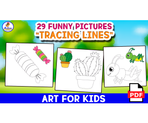
TRACING LINES - 29 Funny Pages
Creative Arts, Art, ELA, Writing, Handwriting, Kindergarten, Preschool, Grade 1, 2, 3, Activities
1. Introduction As is known, reviewing images with dots can offer different benefits and advantages for children. That's why today we present this beautiful worksheet that your children can work with. 2.Objective The objective of this worksheet encompasses the following points: - Develop fine motor skills: Reviewing images with dots involves continuing and following a specific sequence to join or connect the dots in a fine and/or precise way. This process will help and benefit to improve children's fine motor skills, which is crucial and very important for students to later develop activities such as writing, fastening buttons and even manipulating small objects. - Encourage hand-eye coordination: Performing this type of activity such as connecting dots requires students to coordinate their visual movements along with their hand movements. This hand-eye coordination is essential and essential to perform everyday, common tasks and even academic activities such as drawing and writing. - Cognitively stimulate: By performing the sequence of points, students will be practicing cognitive skills such as concentration, attention, as well as following instructions. This will help strengthen your capacity and/or ability to process visual information and improve your focus. - Stimulate numerical and sequential learning: By joining dots in numerical or sequential order, students and/or children will be exposed to understanding numerical and sequential concepts in a fun and visually attractive way. This will help your students understand the number sequence early and encourage pattern recognition. - Creatively stimulate: When students review images with dots, it is not only a structured activity , but it is also considered a form of creative expression. As students complete the images, they will have and can take advantage of the opportunity to use their imagination and creativity to interpret and personalize the drawing that results after connecting the dots. 3.Order, scheme and stages Introduce your class with a motivational song to awaken your students' attention. Then just enter the worksheet. 4.Grades or ages This worksheet is intended for children ages 4 to 8. 5. Form of application Apply this worksheet individually or in groups. 6. Answer keys This game does not require answers. 7.Use text labels art, draw lines, lines, line strokes. 8.Rules Specified above. 9.File types The archive is in PDF format. 10.Number of pages This document contains 29 pages.
Author EDITORIAL LAURA EDUCA
Tags Art, Tracing Lines, Tracing, Handwriting, Coloring, Dots, Tracing Dots

Letter Z Vocabulary and Tracing Cards
ELA, Writing, Handwriting, Language Development, Phonics, Vocabulary, Kindergarten, Preschool, Activities
Letter Z Vocabulary and Tracing Cards This literacy resource provides young learners practice with letter Z phonics. The set includes 12 vocabulary cards showing images of objects starting with Z, plus 12 corresponding uppercase and lowercase Z tracing cards. Teachers can use these cards in small groups or literacy centers to help PreK and kindergarten students identify beginning Z sounds, practice proper letter formation, and develop early reading and writing skills. The vibrant images and clear print promote engagement. Cards can also be displayed on word walls or pocket charts to reinforce lessons. This versatile resource allows teachers to assess knowledge of phonics, penmanship, and manuscript writing in a simple, reusable format.
Author The Connett Connection
Tags Alphabet Activities, Handwriting Practice, Handwriting Center, Writing Center, Vocabulary Cards, Alphabet Vocabulary, Letter Of The Week, Preschool Literacy, Letter Z, Letter Z Activities
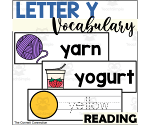
Letter Y Vocabulary and Tracing Cards
ELA, Writing, Handwriting, Language Development, Phonics, Vocabulary, Kindergarten, Preschool, Activities
These vocabulary and tracing cards all students to practice reading and writing letter Y words. These cards include bold, clear, easy to recognize images of objects and ideas that begin with the initial sound of the letter Y that are easily recognized by students. This set contains a total of 12 unique vocabulary cards with their corresponding tracing card, making these cards perfect for a wall display or a writing center activity. What is Included: There are 12 letter Y vocabulary cards There are 12 letter Y tracing cards These vocabulary and tracing cards are suitable for preschoolers and kindergartners who are beginning to learn about words, letters and handwriting. The vocabulary cards provide a way for students to identify things that start with the letter Y and the tracing cards provide students with a fun way to practice letter formation and writing words. When to Use Literacy Center Writing Center Wall display in writing or reading center Small Group Activity Pocket Chart Display Word Wall Cards The vocabulary cards can make a great wall display in a writing center or as part of a word wall. Students will be able to reference the cards when writing or labeling pictures. These cards can also be used as a pocket chart activity where the teacher can introduce different letter V words. Students will love the vibrant, easy to identify pictures and the big, bold words. Skills Assessed Beginning Sounds Tracing Skills Letter Formation for capital and lowercase letters Manuscript Handwriting These cards are a low prep activity for teachers to create. The teacher simply needs to print the cards and cut them out. The cards can be laminated if desired. By laminating the tracing cards, the teacher can create a write and wipe activity with dry erase markers that students can reuse over and over.
Author The Connett Connection
Tags Alphabet Activities, Handwriting Practice, Handwriting Center, Writing Center, Vocabulary Cards, Alphabet Vocabulary, Letter Of The Week, Preschool Literacy, Letter Y, Letter Y Activities
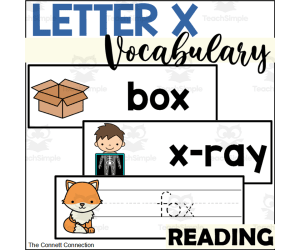
Letter X Vocabulary and Tracing Cards
ELA, Writing, Handwriting, Language Development, Phonics, Vocabulary, Kindergarten, Preschool, Activities
These vocabulary and tracing cards all students to practice reading and writing letter X words. These cards include bold, clear, easy to recognize images of objects and ideas that begin with the initial sound of the letter X that are easily recognized by students. This set contains a total of 12 unique vocabulary cards with their corresponding tracing card, making these cards perfect for a wall display or a writing center activity. What is Included: There are 12 letter X vocabulary cards There are 12 letter X tracing cards These vocabulary and tracing cards are suitable for preschoolers and kindergartners who are beginning to learn about words, letters and handwriting. The vocabulary cards provide a way for students to identify things that start with the letter X and the tracing cards provide students with a fun way to practice letter formation and writing words. When to Use Literacy Center Writing Center Wall display in writing or reading center Small Group Activity Pocket Chart Display Word Wall Cards The vocabulary cards can make a great wall display in a writing center or as part of a word wall. Students will be able to reference the cards when writing or labeling pictures. These cards can also be used as a pocket chart activity where the teacher can introduce different letter X words. Students will love the vibrant, easy to identify pictures and the big, bold words. Skills Assessed Beginning Sounds Tracing Skills Letter Formation for capital and lowercase letters Manuscript Handwriting These cards are a low prep activity for teachers to create. The teacher simply needs to print the cards and cut them out. The cards can be laminated if desired. By laminating the tracing cards, the teacher can create a write and wipe activity with dry erase markers that students can reuse over and over.
Author The Connett Connection
Tags Alphabet Activities, Handwriting Practice, Handwriting Center, Writing Center, Vocabulary Cards, Alphabet Vocabulary, Letter Of The Week, Preschool Literacy, Letter X, Letter X Activities
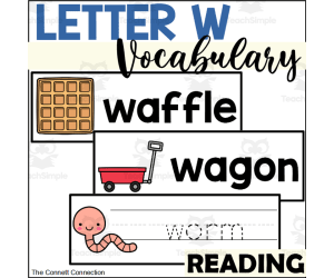
Letter W Vocabulary and Tracing Cards
ELA, Writing, Handwriting, Language Development, Phonics, Vocabulary, Kindergarten, Preschool, Activities
These vocabulary and tracing cards all students to practice reading and writing letter W words. These cards include bold, clear, easy to recognize images of objects and ideas that begin with the initial sound of the letter W that are easily recognized by students. This set contains a total of 12 unique vocabulary cards with their corresponding tracing card, making these cards perfect for a wall display or a writing center activity. What is Included: There are 12 letter W vocabulary cards There are 12 letter W tracing cards These vocabulary and tracing cards are suitable for preschoolers and kindergartners who are beginning to learn about words, letters and handwriting. The vocabulary cards provide a way for students to identify things that start with the letter W and the tracing cards provide students with a fun way to practice letter formation and writing words. When to Use Literacy Center Writing Center Wall display in writing or reading center Small Group Activity Pocket Chart Display Word Wall Cards The vocabulary cards can make a great wall display in a writing center or as part of a word wall. Students will be able to reference the cards when writing or labeling pictures. These cards can also be used as a pocket chart activity where the teacher can introduce different letter W words. Students will love the vibrant, easy to identify pictures and the big, bold words. Skills Assessed Beginning Sounds Tracing Skills Letter Formation for capital and lowercase letters Manuscript Handwriting These cards are a low prep activity for teachers to create. The teacher simply needs to print the cards and cut them out. The cards can be laminated if desired. By laminating the tracing cards, the teacher can create a write and wipe activity with dry erase markers that students can reuse over and over.
Author The Connett Connection
Tags Alphabet Activities, Handwriting Practice, Handwriting Center, Writing Center, Vocabulary Cards, Alphabet Vocabulary, Letter Of The Week, Preschool Literacy, Letter W, Letter W Activities

Letter V Vocabulary and Tracing Cards
ELA, Writing, Handwriting, Language Development, Phonics, Vocabulary, Kindergarten, Preschool, Activities
These vocabulary and tracing cards all students to practice reading and writing letter V words. These cards include bold, clear, easy to recognize images of objects and ideas that begin with the initial sound of the letter V that are easily recognized by students. This set contains a total of 12 unique vocabulary cards with their corresponding tracing card, making these cards perfect for a wall display or a writing center activity. What is Included: There are 12 letter V vocabulary cards There are 12 letter V tracing cards These vocabulary and tracing cards are suitable for preschoolers and kindergartners who are beginning to learn about words, letters and handwriting. The vocabulary cards provide a way for students to identify things that start with the letter V and the tracing cards provide students with a fun way to practice letter formation and writing words. When to Use Literacy Center Writing Center Wall display in writing or reading center Small Group Activity Pocket Chart Display Word Wall Cards The vocabulary cards can make a great wall display in a writing center or as part of a word wall. Students will be able to reference the cards when writing or labeling pictures. These cards can also be used as a pocket chart activity where the teacher can introduce different letter V words. Students will love the vibrant, easy to identify pictures and the big, bold words. Skills Assessed Beginning Sounds Tracing Skills Letter Formation for capital and lowercase letters Manuscript Handwriting These cards are a low prep activity for teachers to create. The teacher simply needs to print the cards and cut them out. The cards can be laminated if desired. By laminating the tracing cards, the teacher can create a write and wipe activity with dry erase markers that students can reuse over and over.
Author The Connett Connection
Tags Alphabet Activities, Handwriting Practice, Handwriting Center, Writing Center, Vocabulary Cards, Alphabet Vocabulary, Letter Of The Week, Preschool Literacy, Letter V, Letter V Activities
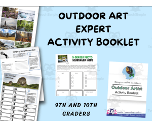
9th and 10th grade Outdoor Artist Activities
Life Studies, Grade 9, 10, Activities
Art isn’t always in a museum or hanging on the walls of schools and buildings, you can find great masterpieces right out in public. These activity will explore art in the outdoors rather than in a building. This activity will give you a chance to get creative and make a few projects that are inspired by the outdoors. Make it for yourself or give it as a gift, and have fun doing it! Make a make a kindness rock First learn how to make the rocks from scratch gathering all your supplies. Then determine where you can participate in the kindness rock project in your neighborhood. Did you know that art is not always visual? Nature is full of sounds that can also be turned into amazing art. Find out more about music in nature in this step. Another way to use art is through a camera. See nature in a way a nature photographer would with this activity. When thinking about nature as being a art piece, many animals are artist in their own way birds build nests, ants build ant hills, etc. There are many ways as humans we can use nature to create art as well. This activity will teach you to use your surroundings to make something new. PDF printable for 9th and 10th grade kids
Author Leader Connecting Leaders
Tags Outdoor Artist, Craft Kids, Art
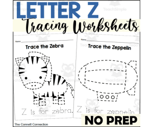
Letter Z Tracing Worksheets
ELA, Writing, Handwriting, Language Development, Phonics, Kindergarten, Preschool, Worksheets & Printables, Worksheets
Letter Z Tracing Worksheets Help young learners practice letter formation and fine motor skills with these letter Z tracing worksheets. Students will trace the pictures and sentences for 3 objects that begin with Z: a zeppelin, zigzag lines, and a zebra. These no-prep printables allow children to trace dotted lines to improve pen control, hand-eye coordination, and dexterity. Use these pages during literacy centers , morning work, small groups, or as homework. Assess skills like letter sounds, printing letters correctly, and fine motor development. Encourage practice using various utensils like markers, beads, paint, and more. These engaging tracing worksheets are suitable for preschoolers and kindergarteners needing extra practice with writing. Laminate them for a reusable write and wipe letter activity. Visit my store for more printable resources that help young learners build alphabet knowledge.
Author The Connett Connection
Tags Tracing Worksheets, Handwriting Practice, Handwriting Worksheets, Alphabet Worksheets, Letter Of The Week, Fine Motor Skills, Writing Center, Letter Z, Letter Z Activities, Letter Z Worksheets
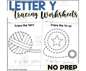
Letter Y Tracing Worksheets
ELA, Writing, Handwriting, Language Development, Phonics, Kindergarten, Preschool, Worksheets & Printables, Worksheets
These letter Y worksheets all students to practice fine motor skills to help them learn handwriting with these object tracing pages. Each page features an object that starts with Y for students to trace. The students can also trace each sentence at the bottom of the page. What is Included: There is a yarn tracing page. There is a yolk tracing page. There is a yo-yo tracing page. These tracing pages are suitable for preschoolers and kindergartners who need extra practice with pen control, hand eye coordination, or fine motor development. The pictures are large, with simple lines for students to trace and then color if desired. Students can also trace the simple sentence at the bottom of the page. Each sentence reads "Y is for ___." When to Use Literacy Center Writing Center Fine Motor Center Morning Work Independent Practice Small Group Activity Homework Emergency Sub Plan Skills Assessed Beginning S Sounds Pen Control Fine Motor Skills Letter Formation These tracing pages are a no prep activity for teachers to give to students. The teacher simply needs to print the pages and give them to students to complete. To make these alphabet tracing worksheets more engaging, teachers can provide a variety of writing utensils with which to complete the pages. Some of these ideas are listed below. Ways to Complete Pencils or colored pencils Markers or crayons Paint with paint brushes or cotton swabs Colorful pens Chalk Finger Tracing Cover with small stickers Cover with manipulatives Dry erase markers These pages can also be laminated to create a write and wipe activity where students can use dry erase markers to complete each page and to have a long-lasting, handy resource. Students may also use small manipulatives like beads or mini erasers to place along the dotted lines to create each shape. For similar resources, visit my store!
Author The Connett Connection
Tags Tracing Worksheets, Handwriting Practice, Handwriting Worksheets, Alphabet Worksheets, Letter Of The Week, Fine Motor Skills, Writing Center, Letter Y, Letter Y Activities, Letter Y Worksheets

Letter X Tracing Worksheets
ELA, Writing, Handwriting, Language Development, Phonics, Kindergarten, Preschool, Worksheets & Printables, Worksheets
These letter X worksheets all students to practice fine motor skills to help them learn handwriting with these object tracing pages. Each page features an object that starts with X for students to trace. The students can also trace each sentence at the bottom of the page. What is Included: There is a x-ray tracing page. There is a xylophone tracing page. There is a volcano tracing page. These tracing pages are suitable for preschoolers and kindergartners who need extra practice with pen control, hand eye coordination, or fine motor development. The pictures are large, with simple lines for students to trace and then color if desired. Students can also trace the simple sentence at the bottom of the page. Each sentence reads "X is for ___." When to Use Literacy Center Writing Center Fine Motor Center Morning Work Independent Practice Small Group Activity Homework Emergency Sub Plan Skills Assessed Beginning S Sounds Pen Control Fine Motor Skills Letter Formation These tracing pages are a no prep activity for teachers to give to students. The teacher simply needs to print the pages and give them to students to complete. To make these alphabet tracing worksheets more engaging, teachers can provide a variety of writing utensils with which to complete the pages. Some of these ideas are listed below. Ways to Complete Pencils or colored pencils Markers or crayons Paint with paint brushes or cotton swabs Colorful pens Chalk Finger Tracing Cover with small stickers Cover with manipulatives Dry erase markers These pages can also be laminated to create a write and wipe activity where students can use dry erase markers to complete each page and to have a long-lasting, handy resource. Students may also use small manipulatives like beads or mini erasers to place along the dotted lines to create each shape. For similar resources, visit my store!
Author The Connett Connection
Tags Tracing Worksheets, Handwriting Practice, Handwriting Worksheets, Alphabet Worksheets, Letter Of The Week, Fine Motor Skills, Writing Center, Letter X, Letter X Worksheets, Letter X Activities
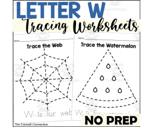
Letter W Tracing Worksheets
ELA, Writing, Handwriting, Language Development, Phonics, Kindergarten, Preschool, Worksheets & Printables, Worksheets
These letter W worksheets all students to practice fine motor skills to help them learn handwriting with these object tracing pages. Each page features an object that starts with W for students to trace. The students can also trace each sentence at the bottom of the page. What is Included: There is a web tracing page. There is a watermelon tracing page. There is a whale tracing page. These tracing pages are suitable for preschoolers and kindergartners who need extra practice with pen control, hand eye coordination, or fine motor development. The pictures are large, with simple lines for students to trace and then color if desired. Students can also trace the simple sentence at the bottom of the page. Each sentence reads "W is for ___." When to Use Literacy Center Writing Center Fine Motor Center Morning Work Independent Practice Small Group Activity Homework Emergency Sub Plan Skills Assessed Beginning S Sounds Pen Control Fine Motor Skills Letter Formation These tracing pages are a no prep activity for teachers to give to students. The teacher simply needs to print the pages and give them to students to complete. To make these alphabet tracing worksheets more engaging, teachers can provide a variety of writing utensils with which to complete the pages. Some of these ideas are listed below. Ways to Complete Pencils or colored pencils Markers or crayons Paint with paint brushes or cotton swabs Colorful pens Chalk Finger Tracing Cover with small stickers Cover with manipulatives Dry erase markers These pages can also be laminated to create a write and wipe activity where students can use dry erase markers to complete each page and to have a long-lasting, handy resource. Students may also use small manipulatives like beads or mini erasers to place along the dotted lines to create each shape. For similar resources, visit my store!
Author The Connett Connection
Tags Tracing Worksheets, Handwriting Practice, Handwriting Worksheets, Alphabet Worksheets, Letter Of The Week, Fine Motor Skills, Writing Center, Letter W, Letter W Activities, Letter W Worksheets
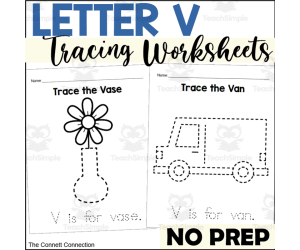
Letter V Tracing Worksheets
ELA, Writing, Handwriting, Language Development, Phonics, Kindergarten, Preschool, Worksheets & Printables, Worksheets
These letter V worksheets all students to practice fine motor skills to help them learn handwriting with these object tracing pages. Each page features an object that starts with V for students to trace. The students can also trace each sentence at the bottom of the page. What is Included: There is a vase tracing page. There is a van tracing page. There is a volcano tracing page. These tracing pages are suitable for preschoolers and kindergartners who need extra practice with pen control, hand eye coordination, or fine motor development. The pictures are large, with simple lines for students to trace and then color if desired. Students can also trace the simple sentence at the bottom of the page. Each sentence reads "V is for ___." When to Use Literacy Center Writing Center Fine Motor Center Morning Work Independent Practice Small Group Activity Homework Emergency Sub Plan Skills Assessed Beginning S Sounds Pen Control Fine Motor Skills Letter Formation These tracing pages are a no prep activity for teachers to give to students. The teacher simply needs to print the pages and give them to students to complete. To make these alphabet tracing worksheets more engaging, teachers can provide a variety of writing utensils with which to complete the pages. Some of these ideas are listed below. Ways to Complete Pencils or colored pencils Markers or crayons Paint with paint brushes or cotton swabs Colorful pens Chalk Finger Tracing Cover with small stickers Cover with manipulatives Dry erase markers These pages can also be laminated to create a write and wipe activity where students can use dry erase markers to complete each page and to have a long-lasting, handy resource. Students may also use small manipulatives like beads or mini erasers to place along the dotted lines to create each shape. For similar resources, visit my store!
Author The Connett Connection
Tags Tracing Worksheets, Handwriting Practice, Handwriting Worksheets, Alphabet Worksheets, Letter Of The Week, Fine Motor Skills, Writing Center, Letter V, Letter V Worksheets, Letter V Activities

Letter Z Spelling Puzzles
ELA, Language Development, Phonics, Spelling, Kindergarten, Preschool, Activities
Practice spelling words that begin with the letter Z with these spelling picture puzzles. There are 5 spelling puzzles in this packet that all begin with the most common initial sound of the letter Z. These spelling puzzles give students a hands on approach to spelling words as well as introducing them to the idea that words are made up of individual letters and sounds. These spelling puzzles are designed for preschoolers and kindergartners who are learning about letter Z words. The puzzles are divided where each letter of the word is on a different piece pf the puzzle. The puzzles use colorful, easy to recognize images that help the student easily put the puzzles together. The large, bold pictures give students an engaging and fun activity to explore how different words are spelled. All of the words in this set begin with the most common initial sound of letter Z. The puzzles in this set include zoo puzzle zap puzzle zucchini puzzle zigzag puzzle zeppelin puzzle When to Use Spelling Activity Literacy Center Puzzle Center Task Box Activity Fine Motor Center Morning Tubs or Morning Baskets Small Group Activity Table Top Activity Students will have a blast spelling words with these puzzles in literacy centers, small groups or individually. They make great table top activities or task box activities. Skills Assessed Spelling simple words Putting together a puzzle Beginning W Sounds These spelling puzzles are a low prep activity for teachers to put together for their students. The teacher simple needs to print out the puzzles and cut them into pieces to create this center activity . The puzzles pieces can be laminated if the teacher desires to do so for durability of the pieces. The puzzles pieces can fit inside a task box for a quick to set up and quick to put away center.
Author The Connett Connection
Tags Spelling Activities, Spelling Puzzles, Alphabet Activities, Alphabet Puzzles, Letter Of The Week, Literacy Center, Preschool Literacy, Kindergarten Literacy, Letter Z, Letter Z Activities
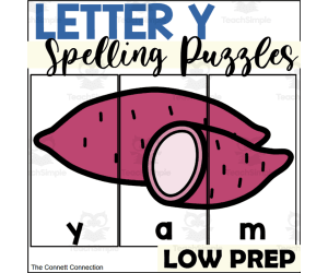
Letter Y Spelling Puzzles
ELA, Language Development, Phonics, Spelling, Kindergarten, Preschool, Activities
Practice spelling words that begin with the letter Y with these spelling picture puzzles. There are 4 spelling puzzles in this packet that all begin with the most common initial sound of the letter Y. These spelling puzzles give students a hands on approach to spelling words as well as introducing them to the idea that words are made up of individual letters and sounds. These spelling puzzles are designed for preschoolers and kindergartners who are learning about letter Y words. The puzzles are divided where each letter of the word is on a different piece pf the puzzle. The puzzles use colorful, easy to recognize images that help the student easily put the puzzles together. The large, bold pictures give students an engaging and fun activity to explore how different words are spelled. All of the words in this set begin with the most common initial sound of letter Y. The puzzles in this set include yam puzzle yarn puzzle yolk puzzle yard puzzle When to Use Spelling Activity Literacy Center Puzzle Center Task Box Activity Fine Motor Center Morning Tubs or Morning Baskets Small Group Activity Table Top Activity Students will have a blast spelling words with these puzzles in literacy centers, small groups or individually. They make great table top activities or task box activities. Skills Assessed Spelling simple words Putting together a puzzle Beginning Y Sounds These spelling puzzles are a low prep activity for teachers to put together for their students. The teacher simple needs to print out the puzzles and cut them into pieces to create this center activity . The puzzles pieces can be laminated if the teacher desires to do so for durability of the pieces. The puzzles pieces can fit inside a task box for a quick to set up and quick to put away center.
Author The Connett Connection
Tags Spelling Activities, Spelling Puzzles, Alphabet Activities, Alphabet Puzzles, Letter Of The Week, Literacy Center, Preschool Literacy, Kindergarten Literacy, Letter Y, Letter Y Activities