2,792 products added recently
Page 634 - Newest Teaching Resources

Creating Dot Plots and Histograms: 6th Grade Statistics and Graphing
Math, Graphing, Statistics, Grade 5, 6, 7, 8, Activities
Here's a ready to go activity for students in 6th grade math class. They will collect numerical data and create their own dot plots and histograms to display their findings! This gives them a sense of ownership over their learning, and it is a great way to assess their skills! Student Instructions: Step 1: Think of a question with 6-8 numerical answer options. For example: ‘How many siblings do you have’ could include the answers 0, 1, 2, 3, 4, 5+ ‘How long does it take you to get to school’ could include 0-10 mins, 10-20 mins, 20-30 mins, 30-40 mins, 40-50 mins, 50-60 mins, and 1hr+ Step 2: Survey at least 20 people. Record each answer with a tally mark in the right column. Step 3: Turn your data set into a dot plot (using the provided template). Step 4: Turn your data set into a histogram (using the provided template). Step 5: Reflect on the process by answering discussion questions and self-assessing your skills. Grades to Use With: This activity is designed to target Common Core Grade 6 Math Statistics Standards, but it could also be used for enrichment in Grade 5, review in Grades 7 or 8, or in high school special education classes. What's Included: 5 Page PDF: Title Page Survey Data Collection Page Dot Plot Template Histogram Template Reflection and Self-Assessment If you enjoy this product, check out other math activities in my store: Double Bar Graph Math Quiz for Grades 3-5: Differentiated Math Project: Create Your Dream Store: Decimal Calculations and Budgeting Financial Literacy: Vacation Math Project: Budgeting, Percentages, Time Zones and More! Math Project: Circle Graphs and Pie Charts Financial Literacy: My Party Budget: Decimals and Percentages Application Math in the Real World: Personal Math Research Project for STEM Education Geometry Project: Park Design with Area, Perimeter, and Volume
Author Grace Under Pressure
Tags Dot Plots, Histograms, Graphing, Data Collection, Statistics, 6th Grade Math, Grade 6 Math, Survey, Applied Math, Data Presentation
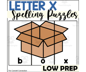
Letter X Spelling Puzzles
ELA, Language Development, Phonics, Spelling, Kindergarten, Preschool, Activities
Letter X Spelling Puzzles These 6 spelling puzzles help preschoolers and kindergartners practice spelling common words with the letter X while having fun. Each colorful puzzle shows an image representing the word, with one letter per puzzle piece. As students put the pieces together to complete the picture, they are reinforcing the correct spelling of words like "box," "ox," "xylophone," and more. These hands-on puzzles introduce early literacy concepts like letter-sound relationships, word construction, and fine motor skills. Add them to literacy centers , morning tubs, tabletops, small groups, or task boxes. The durable printed and laminated pieces store neatly inside the accompanying task box. Skills like spelling, puzzles, and beginning X sounds are assessed in a low-prep activity loved by students.
Author The Connett Connection
Tags Spelling Activities, Spelling Puzzles, Alphabet Activities, Alphabet Puzzles, Letter Of The Week, Literacy Center, Preschool Literacy, Kindergarten Literacy, Letter X, Letter X Activities

Letter V Spelling Puzzles
ELA, Language Development, Phonics, Spelling, Kindergarten, Preschool, Activities
Practice spelling words that begin with the letter V with these spelling picture puzzles. There are 2 spelling puzzles in this packet that all begin with the most common initial sound of the letter V. These spelling puzzles give students a hands on approach to spelling words as well as introducing them to the idea that words are made up of individual letters and sounds. These spelling puzzles are designed for preschoolers and kindergartners who are learning about letter V words. The puzzles are divided where each letter of the word is on a different piece pf the puzzle. The puzzles use colorful, easy to recognize images that help the student easily put the puzzles together. The large, bold pictures give students an engaging and fun activity to explore how different words are spelled. All of the words in this set begin with the most common initial sound of letter V. The puzzles in this set include van puzzle valley puzzle vegetable puzzle When to Use Spelling Activity Literacy Center Puzzle Center Task Box Activity Fine Motor Center Morning Tubs or Morning Baskets Small Group Activity Table Top Activity Students will have a blast spelling words with these puzzles in literacy centers, small groups or individually. They make great table top activities or task box activities. Skills Assessed Spelling simple words Putting together a puzzle Beginning V Sounds These spelling puzzles are a low prep activity for teachers to put together for their students. The teacher simple needs to print out the puzzles and cut them into pieces to create this center activity . The puzzles pieces can be laminated if the teacher desires to do so for durability of the pieces. The puzzles pieces can fit inside a task box for a quick to set up and quick to put away center.
Author The Connett Connection
Tags Spelling Activities, Spelling Puzzles, Alphabet Activities, Alphabet Puzzles, Letter Of The Week, Literacy Center, Preschool Literacy, Kindergarten Literacy, Letter V, Letter V Activities

Letter W Spelling Puzzles
ELA, Language Development, Phonics, Spelling, Kindergarten, Preschool, Activities
Practice spelling words that begin with the letter W with these spelling picture puzzles. There are 3 spelling puzzles in this packet that all begin with the most common initial sound of the letter W. These spelling puzzles give students a hands on approach to spelling words as well as introducing them to the idea that words are made up of individual letters and sounds. These spelling puzzles are designed for preschoolers and kindergartners who are learning about letter W words. The puzzles are divided where each letter of the word is on a different piece pf the puzzle. The puzzles use colorful, easy to recognize images that help the student easily put the puzzles together. The large, bold pictures give students an engaging and fun activity to explore how different words are spelled. All of the words in this set begin with the most common initial sound of letter W. The puzzles in this set include wand puzzle worm puzzle wave puzzle When to Use Spelling Activity Literacy Center Puzzle Center Task Box Activity Fine Motor Center Morning Tubs or Morning Baskets Small Group Activity Table Top Activity Students will have a blast spelling words with these puzzles in literacy centers, small groups or individually. They make great table top activities or task box activities. Skills Assessed Spelling simple words Putting together a puzzle Beginning W Sounds These spelling puzzles are a low prep activity for teachers to put together for their students. The teacher simple needs to print out the puzzles and cut them into pieces to create this center activity . The puzzles pieces can be laminated if the teacher desires to do so for durability of the pieces. The puzzles pieces can fit inside a task box for a quick to set up and quick to put away center.
Author The Connett Connection
Tags Spelling Activities, Spelling Puzzles, Alphabet Activities, Alphabet Puzzles, Letter Of The Week, Literacy Center, Preschool Literacy, Kindergarten Literacy, Letter W, Letter W Activities

Letter Z Seek and Find Worksheets
Math, Early Math, Numbers, Kindergarten, Preschool, Worksheets & Printables, Worksheets
With these Letter Z Seek and Find Worksheets, students will practice recognizing words that begin with the letter Z while counting tally marks and identifying color words with these seek and find worksheets. Students will love being able to practice math skills and reading color words while using images they already know. What is Included: There is 1 find and tally worksheets in color There is 1 find and tally worksheet in black and white There is 1 find and color worksheet To complete the find and color worksheet, students will read the color word by each picture. They will color all the images that match the picture the color indicated in the key. To complete the count and tally worksheets, students will count all the occurrences of a given picture and then mark their counting with tally marks in the boxes provided next to the appropriate picture. All images on each worksheet begin with the letter Z. When to Use Literacy Center Math Center Morning Work Emergency Sub Plans Small Group Activity Independent Activity File Folder Activity Write and Wipe Activity Skills Assessed Beginning Sounds Matching Like Pictures Reading Color Words Counting Pictures in a Random Order Making and Counting Tally Marks Fine Motor Skills These worksheets are no prep. Teachers simply need to print the pages and hand them to the students to complete. To make the find and color page more interesting, teachers may give students colored dot markers to complete the worksheet. The count and tally pages can be laminated to make a write and whip activity for students to use over and over. The count and tally pages can also be placed inside a file folder for easy set up and clean up. For similar resources for the Letter Z learning and more visit my store here!
Author The Connett Connection
Tags Alphabet Activities, Seek And Find, Tally Marks, Counting Worksheets, Hide And Seek, Letter Of The Week, Alphabet Worksheets, Preschool Worksheets, Letter Z, Letter Z Activities
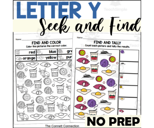
Letter Y Seek and Find Worksheets
Math, Early Math, Numbers, Kindergarten, Preschool, Worksheets & Printables, Worksheets
With these Letter Y Seek and Find Worksheets, students will practice recognizing words that begin with the letter Y while counting tally marks and identifying color words with these seek and find worksheets. Students will love being able to practice math skills and reading color words while using images they already know. What is Included: There is 1 find and tally worksheets in color There is 1 find and tally worksheet in black and white There is 1 find and color worksheet To complete the find and color worksheet, students will read the color word by each picture. They will color all the images that match the picture the color indicated in the key. To complete the count and tally worksheets, students will count all the occurrences of a given picture and then mark their counting with tally marks in the boxes provided next to the appropriate picture. All images on each worksheet begin with the letter Y. When to Use Literacy Center Math Center Morning Work Emergency Sub Plans Small Group Activity Independent Activity File Folder Activity Write and Wipe Activity Skills Assessed Beginning Sounds Matching Like Pictures Reading Color Words Counting Pictures in a Random Order Making and Counting Tally Marks Fine Motor Skills These worksheets are no prep. Teachers simply need to print the pages and hand them to the students to complete. To make the find and color page more interesting, teachers may give students colored dot markers to complete the worksheet. The count and tally pages can be laminated to make a write and whip activity for students to use over and over. The count and tally pages can also be placed inside a file folder for easy set up and clean up. For similar resources for the Letter Y learning and more visit my store here!
Author The Connett Connection
Tags Alphabet Activities, Seek And Find, Tally Marks, Counting Worksheets, Hide And Seek, Letter Of The Week, Alphabet Worksheets, Preschool Worksheets, Letter Y, Letter Y Worksheets
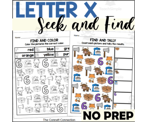
Letter X Seek and Find Worksheets
Math, Early Math, Numbers, Kindergarten, Preschool, Worksheets & Printables, Worksheets
With these Letter X Seek and Find Worksheets, students will practice recognizing words that end with the letter X while counting tally marks and identifying color words with these seek and find worksheets. Students will love being able to practice math skills and reading color words while using images they already know. What is Included: There is 1 find and tally worksheets in color There is 1 find and tally worksheet in black and white There is 1 find and color worksheet To complete the find and color worksheet, students will read the color word by each picture. They will color all the images that match the picture the color indicated in the key. To complete the count and tally worksheets, students will count all the occurrences of a given picture and then mark their counting with tally marks in the boxes provided next to the appropriate picture. All images on each worksheet end with the letter X. When to Use Literacy Center Math Center Morning Work Emergency Sub Plans Small Group Activity Independent Activity File Folder Activity Write and Wipe Activity Skills Assessed Beginning Sounds Matching Like Pictures Reading Color Words Counting Pictures in a Random Order Making and Counting Tally Marks Fine Motor Skills These worksheets are no prep. Teachers simply need to print the pages and hand them to the students to complete. To make the find and color page more interesting, teachers may give students colored dot markers to complete the worksheet. The count and tally pages can be laminated to make a write and whip activity for students to use over and over. The count and tally pages can also be placed inside a file folder for easy set up and clean up. For similar resources for the Letter X learning and more visit my store here!
Author The Connett Connection
Tags Alphabet Activities, Seek And Find, Tally Marks, Counting Worksheets, Hide And Seek, Letter Of The Week, Alphabet Worksheets, Preschool Worksheets, Letter X, Letter X Worksheets
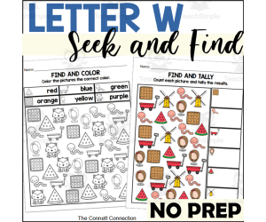
Letter W Seek and Find Worksheets
Math, Early Math, Numbers, Kindergarten, Preschool, Worksheets & Printables, Worksheets
With these Letter W Seek and Find Worksheets, students will practice recognizing words that begin with the letter W while counting tally marks and identifying color words with these seek and find worksheets. Students will love being able to practice math skills and reading color words while using images they already know. What is Included: There is 1 find and tally worksheets in color There is 1 find and tally worksheet in black and white There is 1 find and color worksheet To complete the find and color worksheet, students will read the color word by each picture. They will color all the images that match the picture the color indicated in the key. To complete the count and tally worksheets, students will count all the occurrences of a given picture and then mark their counting with tally marks in the boxes provided next to the appropriate picture. All images on each worksheet begin with the letter W. When to Use Literacy Center Math Center Morning Work Emergency Sub Plans Small Group Activity Independent Activity File Folder Activity Write and Wipe Activity Skills Assessed Beginning Sounds Matching Like Pictures Reading Color Words Counting Pictures in a Random Order Making and Counting Tally Marks Fine Motor Skills These worksheets are no prep. Teachers simply need to print the pages and hand them to the students to complete. To make the find and color page more interesting, teachers may give students colored dot markers to complete the worksheet. The count and tally pages can be laminated to make a write and whip activity for students to use over and over. The count and tally pages can also be placed inside a file folder for easy set up and clean up. For similar resources for the Letter W learning and more visit my store here!
Author The Connett Connection
Tags Alphabet Activities, Seek And Find, Tally Marks, Counting Worksheets, Hide And Seek, Letter Of The Week, Alphabet Worksheets, Preschool Worksheets, Letter W, Letter W Activities

Letter V Seek and Find Worksheets
Math, Early Math, Numbers, Kindergarten, Preschool, Worksheets & Printables, Worksheets
With these Letter V Seek and Find Worksheets, students will practice recognizing words that begin with the letter V while counting tally marks and identifying color words with these seek and find worksheets. Students will love being able to practice math skills and reading color words while using images they already know. What is Included: There is 1 find and tally worksheets in color There is 1 find and tally worksheet in black and white There is 1 find and color worksheet To complete the find and color worksheet, students will read the color word by each picture. They will color all the images that match the picture the color indicated in the key. To complete the count and tally worksheets, students will count all the occurrences of a given picture and then mark their counting with tally marks in the boxes provided next to the appropriate picture. All images on each worksheet begin with the letter V. When to Use Literacy Center Math Center Morning Work Emergency Sub Plans Small Group Activity Independent Activity File Folder Activity Write and Wipe Activity Skills Assessed Beginning Sounds Matching Like Pictures Reading Color Words Counting Pictures in a Random Order Making and Counting Tally Marks Fine Motor Skills These worksheets are no prep. Teachers simply need to print the pages and hand them to the students to complete. To make the find and color page more interesting, teachers may give students colored dot markers to complete the worksheet. The count and tally pages can be laminated to make a write and whip activity for students to use over and over. The count and tally pages can also be placed inside a file folder for easy set up and clean up. For similar resources for the Letter V learning and more visit my store here!
Author The Connett Connection
Tags Alphabet Activities, Seek And Find, Tally Marks, Counting Worksheets, Hide And Seek, Letter Of The Week, Alphabet Worksheets, Preschool Worksheets, Letter V, Letter V Worksheets

Letter Z Reading Strips
ELA, Language Development, Phonics, Reading, Kindergarten, Preschool, Activities
Practice reading simple sentences with these letter Z reading strips. Students will read words that begin with the letter Z using the picture clue on each strip. There are 14 total reading strips that focus on the initial /z/ sound. All sentences are in the form of "Z is for ___." These letter Z reading strips are suitable to preschool or kindergarten kids who are learning to identify the initial sound of the letter Z. These cards are perfect for introducing new vocabulary to students. What is Included: This resource contains 14 reading strips for the letter Z. When to Use: Literacy Centers - These cards work well in a literacy or reading center for students to read independently or with a partner. Small Group Activity - The teacher can pull aside a small group of students who need extra practice with the target sound to use these cards. Early Finisher Task - If students finish a task early, they can grab these cards to look at and read. Take Home Book - The black and white pages can be sent home for students to make their own letter sound book. Task Box Activity by using pencil boxes Ways to Use Teachers can place the cards on a ring for a simple reading ring for a reading center . The teacher can cut the picture from the strip and have students match the picture to the sentence. Teachers can have simply have students read the strips to practice recognizing words that begin with the target letter. Skills Assessed: Reading Simple Sentences Beginning Sounds Using picture clues to figure out new words These reading strips are a low prep activity. The teacher simply needs to print out the strips and then cut them apart to create this activity. The strips can be laminated if desired. They can be places in a reading or literacy center and used over and over. By placing these strips on a ring or in a pencil box, students can easily take out and clean up this literacy center . These strips can be combined with the strips for other letters to create a sorting activity. Students can also sort the strips according to each beginning sound.
Author The Connett Connection
Tags Beginning Sounds, Alphabet Activities, Letter Of The Week, Reading Center, Reading Simple Sentences, Simple Sentences, Initial Sounds, Preschool Reading Center, Letter Z, Letter Z Activities

Letter Y Reading Strips
ELA, Language Development, Phonics, Reading, Kindergarten, Preschool, Activities
Practice reading simple sentences with these letter Y reading strips. Students will read words that begin with the letter Y using the picture clue on each strip. There are 14 total reading strips that focus on the initial /y/ sound. All sentences are in the form of "Y is for ___." These letter Y reading strips are suitable to preschool or kindergarten kids who are learning to identify the initial sound of the letter Y. These cards are perfect for introducing new vocabulary to students. What is Included: This resource contains 14 reading strips for the letter Y. When to Use: Literacy Centers - These cards work well in a literacy or reading center for students to read independently or with a partner. Small Group Activity - The teacher can pull aside a small group of students who need extra practice with the target sound to use these cards. Early Finisher Task - If students finish a task early, they can grab these cards to look at and read. Take Home Book - The black and white pages can be sent home for students to make their own letter sound book. Task Box Activity by using pencil boxes Ways to Use Teachers can place the cards on a ring for a simple reading ring for a reading center . The teacher can cut the picture from the strip and have students match the picture to the sentence. Teachers can have simply have students read the strips to practice recognizing words that begin with the target letter. Skills Assessed: Reading Simple Sentences Beginning Sounds Using picture clues to figure out new words These reading strips are a low prep activity. The teacher simply needs to print out the strips and then cut them apart to create this activity. The strips can be laminated if desired. They can be places in a reading or literacy center and used over and over. By placing these strips on a ring or in a pencil box, students can easily take out and clean up this literacy center . These strips can be combined with the strips for other letters to create a sorting activity. Students can also sort the strips according to each beginning sound.
Author The Connett Connection
Tags Beginning Sounds, Alphabet Activities, Letter Of The Week, Reading Center, Reading Simple Sentences, Simple Sentences, Initial Sounds, Preschool Reading Center, Letter V, Letter V Activities
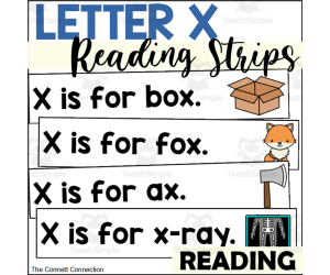
Letter X Reading Strips
ELA, Language Development, Phonics, Reading, Kindergarten, Preschool, Activities
Practice reading simple sentences with these letter X reading strips. Students will read words that have the letter X using the picture clue on each strip. There are 14 total reading strips that focus on the /x/ sound. All sentences are in the form of "X is for ___." These letter X reading strips are suitable to preschool or kindergarten kids who are learning to identify the sounds of the letter X. These cards are perfect for introducing new vocabulary to students. What is Included: This resource contains 14 reading strips for the letter X. When to Use: Literacy Centers - These cards work well in a literacy or reading center for students to read independently or with a partner. Small Group Activity - The teacher can pull aside a small group of students who need extra practice with the target sound to use these cards. Early Finisher Task - If students finish a task early, they can grab these cards to look at and read. Take Home Book - The black and white pages can be sent home for students to make their own letter sound book. Task Box Activity by using pencil boxes Ways to Use Teachers can place the cards on a ring for a simple reading ring for a reading center . The teacher can cut the picture from the strip and have students match the picture to the sentence. Teachers can have simply have students read the strips to practice recognizing words that begin with the target letter. Skills Assessed: Reading Simple Sentences Beginning Sounds Using picture clues to figure out new words These reading strips are a low prep activity. The teacher simply needs to print out the strips and then cut them apart to create this activity. The strips can be laminated if desired. They can be places in a reading or literacy center and used over and over. By placing these strips on a ring or in a pencil box, students can easily take out and clean up this literacy center . These strips can be combined with the strips for other letters to create a sorting activity. Students can also sort the strips according to each beginning sound.
Author The Connett Connection
Tags Beginning Sounds, Alphabet Activities, Letter Of The Week, Reading Center, Reading Simple Sentences, Simple Sentences, Initial Sounds, Preschool Reading Center, Letter X, Letter X Activities

Letter W Reading Strips
ELA, Language Development, Phonics, Reading, Kindergarten, Preschool, Activities
Practice reading simple sentences with these letter W reading strips. Students will read words that begin with the letter V using the picture clue on each strip. There are 14 total reading strips that focus on the initial /w/ sound. All sentences are in the form of "W is for ___." These letter W reading strips are suitable to preschool or kindergarten kids who are learning to identify the initial sound of the letter W. These cards are perfect for introducing new vocabulary to students. What is Included: This resource contains 14 reading strips for the letter W. When to Use: Literacy Centers - These cards work well in a literacy or reading center for students to read independently or with a partner. Small Group Activity - The teacher can pull aside a small group of students who need extra practice with the target sound to use these cards. Early Finisher Task - If students finish a task early, they can grab these cards to look at and read. Take Home Book - The black and white pages can be sent home for students to make their own letter sound book. Task Box Activity by using pencil boxes Ways to Use Teachers can place the cards on a ring for a simple reading ring for a reading center . The teacher can cut the picture from the strip and have students match the picture to the sentence. Teachers can have simply have students read the strips to practice recognizing words that begin with the target letter. Skills Assessed: Reading Simple Sentences Beginning Sounds Using picture clues to figure out new words These reading strips are a low prep activity. The teacher simply needs to print out the strips and then cut them apart to create this activity. The strips can be laminated if desired. They can be places in a reading or literacy center and used over and over. By placing these strips on a ring or in a pencil box, students can easily take out and clean up this literacy center . These strips can be combined with the strips for other letters to create a sorting activity. Students can also sort the strips according to each beginning sound.
Author The Connett Connection
Tags Beginning Sounds, Alphabet Activities, Letter Of The Week, Reading Center, Reading Simple Sentences, Simple Sentences, Initial Sounds, Preschool Reading Center, Letter W, Letter W Activities
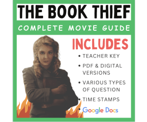
The Book Thief (2013): Complete Movie Guide
ELA, Grade 7, 8, 9, 10, Worksheets & Printables, Worksheets
The film adaptation of "The Book Thief" was released in 2013, directed by Brian Percival. The movie stays true to the essence of the novel and captures the emotional depth of the story. The film begins with Liesel Meminger (Sophie Nélisse) being sent to live with foster parents, Hans (Geoffrey Rush) and Rosa Hubermann (Emily Watson), in a small German town during World War II. Liesel struggles to adapt to her new life and finds solace in books. She learns to read with the help of her foster father, who also teaches her the power of words and storytelling. As Liesel becomes engrossed in her newfound love for reading, she starts stealing books, hence earning the nickname "The Book Thief." With her friend Rudy Steiner (Nico Liersch), she embarks on various adventures and becomes a voracious reader. Amidst the war and the oppressive atmosphere of Nazi Germany, Liesel discovers the power of words to connect people, bring comfort, and challenge the prevailing ideology. Throughout the film, Liesel's relationships deepen. She forms a bond with Max Vandenburg (Ben Schnetzer), a Jewish refugee who seeks shelter in her basement. Max and Liesel share a love for words, and their friendship grows despite the risks involved. Hans, Rosa, and Liesel form a loving and unconventional family unit , supporting one another in the face of adversity. As the war intensifies, Liesel and her community face the devastating impact of bombings and loss. The film explores themes of resilience, compassion, and the human spirit's ability to find light in even the darkest times. "The Book Thief" movie captures the emotional journey of Liesel and the people around her, emphasizing the transformative power of books and storytelling. It portrays the horrors of war, the importance of empathy and love, and the enduring impact of words and literature. This product includes 34-questions that will help your students get the most out of this powerful film. This product will help hold your students accountable for the information in the movie, without interfering with the video. The product also includes time stamps, a character map, and a complete teacher key. Ready to use - no prep!
Author EduPal Learning
Tags Nazi Germany, Book Bans, The Book Thief, Movie Guide, Ben Schnetzer Max Vandenburg

Letter V Reading Strips
ELA, Language Development, Phonics, Reading, Kindergarten, Preschool, Activities
Practice reading simple sentences with these letter V reading strips. Students will read words that begin with the letter V using the picture clue on each strip. There are 14 total reading strips that focus on the initial /v/ sound. All sentences are in the form of "V is for ___." These letter V reading strips are suitable to preschool or kindergarten kids who are learning to identify the initial sound of the letter V. These cards are perfect for introducing new vocabulary to students. What is Included: This resource contains 14 reading strips for the letter V. When to Use: Literacy Centers - These cards work well in a literacy or reading center for students to read independently or with a partner. Small Group Activity - The teacher can pull aside a small group of students who need extra practice with the target sound to use these cards. Early Finisher Task - If students finish a task early, they can grab these cards to look at and read. Take Home Book - The black and white pages can be sent home for students to make their own letter sound book. Task Box Activity by using pencil boxes Ways to Use Teachers can place the cards on a ring for a simple reading ring for a reading center . The teacher can cut the picture from the strip and have students match the picture to the sentence. Teachers can have simply have students read the strips to practice recognizing words that begin with the target letter. Skills Assessed: Reading Simple Sentences Beginning Sounds Using picture clues to figure out new words These reading strips are a low prep activity. The teacher simply needs to print out the strips and then cut them apart to create this activity. The strips can be laminated if desired. They can be places in a reading or literacy center and used over and over. By placing these strips on a ring or in a pencil box, students can easily take out and clean up this literacy center . These strips can be combined with the strips for other letters to create a sorting activity. Students can also sort the strips according to each beginning sound.
Author The Connett Connection
Tags Beginning Sounds, Alphabet Activities, Letter Of The Week, Reading Center, Reading Simple Sentences, Simple Sentences, Initial Sounds, Preschool Reading Center, Letter V, Letter V Activities

Country Study on France - Reseach Project + fishing Cards + Worksheet
Social Studies, Geography, History, History: Europe, Research, Grade 7, 8, 9, 10, 11, 12, Activities, Projects
Country Study on France - Reseach Project + fishing Cards + Worksheet This Teaching Resource is a PDF research project (10 Slides) on France. This Printable Resource can be great for Geography, European History and Social Studies Classes. Suitable Learners for this kind of lesson are students from 7th Grade to 12th Grade. This Geography + Social Studies Research Project on France (country Study) aims to make learners discover France (history, geography, economy, Paris and culture). Little preparation can be helpful. If you need some help to introduce your Social Studies + Geography students and learners to France and French Culture, then you can't miss this Teaching Resource Country Study Presentation on France Within this Country Study on France Research Project, it is offered: 2 worksheets to write research outcomes 64 Cards to fish for this Research Project on France How does this Country Study on France Teaching Resource work? learners (or groups) fish a Research Topic card of each color (black for history, blue for geography, orange for economy, Red for Paris and green for French Culture) each student or group makes their personalized Research on France, by focusing on their fished topic cards (ex. fished black card on history on "The Gauls", blue card on geography on "Weather in France", orange card on economy on "Tertiary Sector", Red Cards on Paris on the Musée du Louvre and a green card on French Culture on Debussy) Learners stick their fished cards on their research worksheet and write their Research outcomes Learners make a presentation on their personalized rersearch on France teacher evaluates research given learner or group's research outcomes written on worksheets Why is this Teaching Resource worth using? By fishing topic cards, students have a chance to: make unique randomized research projects focus on specific topics only and discover more the research country in "non-superficial" ways Connect their own Research outcomes with their peers' This Social Studies + Geography Country Study on France PDF Printable Research Project on France Teaching (10 slides) can be great for learners from 7th grade to 12th grade to introduce France and its Culture. Learning with Alan is a Brand New Teaching Resource/Educational Material Store whose aim is to help Teachers, Educators and Tutors to achieve their teaching objectives while creating a fun and stimulating environment. Never Forget! If you want to browse more of my Teaching Resources, click here Learning with Alan!
Author Learning with Alan
Tags France, Country Study, Research Project, Europe, European History, Geography, Social Studies, Cards, Worksheet, Printable
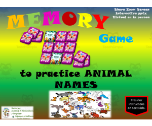
Free Interactive Memory Game to Practice Animals
Life Studies, ELA, Reading, Reading Comprehension, Language Development, Pre-Reading, Spelling, Vocabulary, Kindergarten, Preschool, Grade 1, 2, 3, Games, Activities
Practice Animal Vocabulary with this Free Interactive Memory Game Introduce young learners to a variety of animals with this entertaining digital memory game . Students will see the name and image of 12 different animals. Their task is to flip over two cards at a time to find matches, exercising visual memory and concentration. If the cards don't match, they flip them back over and try again. Once all matches are made, press the "start again" button for more vocabulary practice. This self-checking activity can be played independently or as a whole class game projected on a smartboard. The vibrant slideshow stimulates engagement while building animal classification skills. Differentiate by allowing lower grades to match pictures only and upper grades to match Spanish vocabulary words. Download this versatile 12-slide PowerPoint today!
Author ShapeUp-N-Matematicas y Lenguaje
Tags Animals, Animal Names, Vocabulary, Domestic Animals, Zoology, Birds, Reptiles, Fish, Mammals, Small Or Whole Group

TRACING LINES - 14 Exercises Pages
ELA, Writing, Handwriting, Kindergarten, Preschool, Grade 1, 2, Activities
1. Introduction As is known by educational agents, graphomotor skills refer to the sets of skills and/or abilities that involve hand-eye coordination during the writing and drawing activities carried out by the child, which provides great benefits for the development of the students. For this reason, today I have created this fantastic educational worksheet for your students. 2.Objective The objectives of this sheet are: - Develop fine motor coordination: As is known, graphomotor skills involve fine and coordinated movements of the fingers and hands. By practicing activities that require the exercise of precise strokes, students will improve their fine motor coordination, which is essential for them to later perform common day-to-day activities such as fastening buttons, writing, tracing, etc. - Prepare for writing: Graphomotor skills are an important precursor activity for the development of the next reading skills. It is through these activities that involve making strokes and lines, that children will strengthen the muscles necessary to then hold the pencil properly as well as coordinate movements to form numbers and letters. -Stimulate cognitive development: As is known, the connection between hand movement and vision during graphomotor skills will stimulate the cognitive development of students. Thus, children will learn to observe, plan as well as execute specific movements, which will contribute to the development and exercise of cognitive skills such as memory and attention. - Encourage creativity and artistic expression: Graphomotor skills are not only restricted to writing, but also involve artistic activities such as coloring and drawing. All of these activities will not only develop motor skills, but will also encourage students' creativity and artistic expression by giving them the opportunity to put their ideas on paper. 3.Order, scheme and stages First start your class with an activity that stimulates your children, such as a short dynamic, song, and then just start with the present activity . 4.Grades or ages This worksheet is planned for children ages 4-7. 5. Form of application This sheet must be applied individually. 6. Answer keys This educational product does not require an answer key. 7.Use text labels graphomotor skills, strokes, drawing lines, strokes for children. 8.Rules Specified above. 9.File types The archive is in PDF format. 10.Number of pages This document contains 14 pages.
Author EDITORIAL LAURA EDUCA
Tags Handwriting, Graphomotricity, Tracing Lines, Tracing, Tracing For Kids

Free Interactive Memory Game to Practice Days of the Week
Life Studies, ELA, Reading, Reading Comprehension, Language Development, Pre-Reading, Spelling, Vocabulary, Writing, Kindergarten, Preschool, Grade 1, 2, 3, Games, Activities
Practice Days of the Week with this Interactive Memory Game Students will love learning and reviewing the days of the week with this engaging digital memory game. The game strengthens visual memory, short-term memory, concentration, and more as students flip over cards to find matches. To play, students first learn the words on the slides. Then they click on card coordinates to reveal pictures and words. If the cards don't match, students flip them back over and try again. When all cards are matched, press the circular "Start Again" button for another round! Use this 7-slide PowerPoint in whole group, small group, centers, or as a computer activity . The game entertains while building language arts skills. Check out more Spanish games and activities from ShapeUp-N-Matematicas y Lenguaje in our TpT store.
Author ShapeUp-N-Matematicas y Lenguaje
Tags Days Of The Week, Weekdays, Games, Memory Game, Small Or Whole Group, Interactive Activity, Week, Date, Days, Day

Country Study on France Snakes and Ladders Board Game PDF Printable
Social Studies, Geography, History, History: Europe, Grade 7, 8, 9, 10, 11, 12, Worksheets, Worksheets & Printables
Country Study on France Snakes and Ladders Board Game PDF Printable This Teaching Resource is a PDF Board game (Snakes and Ladders; 3 slides) on France (Europe). This Printable Resource can be great for Geography, European History and Social Studies Classes. Suitable Learners for this kind of lesson are students from 7th Grade to 12th Grade. This Geography + Social Studies game on France (country Study) aims to test learners on their knowledge on France and French Culture (naming 4 French cities, telling about history events, telling about your pawn's character, telling about 6 Famous French individuals or teling what you would like to visit). Some preparation on France can be useful for this Social Studies Activity. If you need a Geography + Social Studies + European History Teaching Resource to introduce your learners to France and French Culture, then you can't miss this Country Study Presentation on France Within this amazing Country Study on France (Europe) board game (snakes and ladders; 3 PDF Printable slides) it is offered: 1 board with questions and Speaking Prompts (ex. name 4 French Cities or telling about French history events such as the French Revolution or the Gauls etc) 1 Printable Craft Die with numbers written 1 Printable Craft cone to make Game Pawns to play 5 Famous People from France (Napoleon, Voltaire, Pierre Currie, Charlemagne etc.) to stick on the printable craft cone This amazing Social Studies + Geography Country Study on France (Europe) PDF Digital Teaching Resource (3 PDF Printable Slides) can be great for learners from 7th grade to 12th grade to test France and its Culture. Learning with Alan is a Brand New Teaching Resource, Educational Material Store whose aim is to help Teachers, Educators and Tutors to achieve their teaching objectives while creating a fun and stimulating environment. Never Forget! If you want to browse more of my Teaching Resources, click here Learning with Alan
Author Learning with Alan
Tags France, Europe, Geography, Social Studies, European Country, Printable, Board Game, Snakes And Ladders, Game, Country Study

Free Science Magnetic Field Interactive Vocabulary Review Activity
Science, Basic Science, Earth and Environmental Sciences, Earth Sciences, Environmental Science, Grade 8, Teacher Tools, Lesson Plans
Interactive Science Vocabulary Review: 8th Grade Magnetic Fields Engage 8th grade students by reviewing key science vocabulary words related to magnetic fields. This interactive PowerPoint allows the whole class or small groups to practice 21 important terms. First, students review a slide defining each vocabulary word. Next, they read four possible choices and select the correct meaning. If right, the answer is revealed. If wrong, students try again until success. Press the down arrow to advance to the next term. The multiple-choice format helps students retain knowledge on magnetic fields. Educators can track comprehension and reteach concepts as needed. Use this resource alongside 8th grade science curriculum or for test prep. Consider implementing during stations, warm-ups, or assessments . Modify for in-person or distance formats. See our store for 7th and 8th grade science review games on additional topics like human microbiome, metabolism, geology, astronomy, reproduction, and more Spanish language activities.
Author ShapeUp-N-Matematicas y Lenguaje
Tags Magnetic Field, Compass, Transfer, Kinetic Energy, Potential Energy, Energy, Force, Small Or Whole Group, Games, Interactive Activity
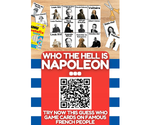
Country Study on France - Guess Who Game Cards on Famous French People
Social Studies, Geography, History, History: Europe, Grade 6, 7, 8, 9, 10, 11, 12, Activities, Games
Country Study on France - Guess Who Game Cards on Famous French People This Teaching Resource is an fun Guess Who Game PDF Presentation (2 slides, 40 cards) on Famous French People. This Digital Resource can be great for Geography, European History and Social Studies Classes. Suitable Learners for this kind of lesson are students from 6th Grade to 12th Grade. This Geography + Social Studies Guess Who Game on Famous People from France (Country Study) aims to introduce learners to France and its most famous people (leaders, kings, fashion designers, philosophers, writers etc.). Little Preparation is needed for this Social Studies + Geography Activity. If you need a little help to introduce your students and learners to France and French Culture, try this: Country Study Presentation on France Some of the French People selected for this Geography + Social Studies + European History Country Study on France are: Charles de Gaulle Coco Chanel Napoleon Victor Hugo Jeanne d'Arc Claude Monet Gustave Eiffel Louis XIV Voltaire Marie Antoinette Édith Piaf Charlemagne Maximilien de Robespierre Christian Dior Jean-Paul Gaultier Yves Saint Laurent Astérix Jules Verne Simone de Beauvoir Jean-Paul Sartre and many more! a fun and engaging way to play this "Guess Who" game can be the following: all Learners sit on the floor in a circle every Learner has a Flash Card on their face every Learner/player asks a question about their Flash Card 's famous French character This Social Studies + Geography Country Study on France PDF Digital Teaching Resource (2 slides, 40 cards for 40 Famous People from France) can be great for learners from 6th grade to 12th grade to introduce France and its Culture through its most important and celebrated people. Learning with Alan is a Brand New Teaching Resource/Educational Material Store whose aim is to help Teachers, Educators and Tutors to achieve their teaching objectives while creating a fun and stimulating environment. Never Forget! If you want to browse more of my Teaching Resources, click here Learning with Alan!
Author Learning with Alan
Tags France, European History, Europe, Geography, Guess Who, Cards, Game, Printable, Culture, Social Studies

Free Science Light Waves Interactive Vocabulary Review Activity
Science, Earth and Environmental Sciences, Space, Basic Science, Earth Sciences, Environmental Science, Grade 8, Teacher Tools, Lesson Plans
Free Science Light Waves Interactive Vocabulary Review for Grade 8 This educational resource helps 8th grade students learn, practice, and review key vocabulary about light waves. Created as part of the science curriculum , it uses visual aids and interactive activities to reinforce concepts. First, students review a PowerPoint presentation practicing the words. Then they read aloud each term and choose the correct multiple choice definition. If correct, the answer is revealed. If not, they keep trying. There are over 30 slides focused specifically on light wave concepts like characteristics and importance. The multiple choice format allows for whole group or individual practice. Differentiated learning helps students at various levels strengthen their understanding. Check out other 8th grade science review games from ShapeUp-N-Matematicas y Lenguaje like force and motion, Earth science, reproduction, and more Spanish language arts activities for engaging academic support.
Author ShapeUp-N-Matematicas y Lenguaje
Tags Light Waves, Ultraviolet, Visualized, Frequency, Light, Wavelenght, Small Or Whole Group, Interactive Activity, Energy, Games
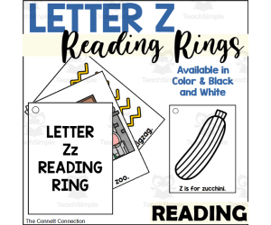
Letter Z Reading Rings
ELA, Language Development, Phonics, Reading, Kindergarten, Preschool, Worksheets & Printables, Flashcards
These letter Z reading rings are great for students learning the beginning sound of the letter Z. These reading rings give students simple sentences to introduce them to reading in the format of "Z is for ____." What is Included: Letter Z Reading Ring cover card Letter Z reading ring cards The reading rings are available in color and in black and white These reading rings are suitable for preschool and kindergarten students who are learning the initial sound of the letter Z and are ready to begin reading simple sentences. The large, bold, and easy to recognize images will lead students towards success as they take the first steps to reading independently. When to Use: Literacy Centers - These cards work well in a literacy or reading center for students to read independently or with a partner. Small Group Activity - The teacher can pull aside a small group of students who need extra practice with the target sound to use these cards. Early Finisher Task - If students finish a task early, they can grab these cards to look at and read. Take Home Book - The black and white pages can be sent home for students to make their own letter sound book. This rings are easy to create. The teacher just needs to print each page, laminate each card (if desired) and then, using a hole punch, the teacher needs to place a hold in the indicated corner of the card. The cards are then placed on a ring for students to flip through each letter Z card. Skills Assessed Letter Z Recognition Beginning Sounds Reading Simple Sentences These reading rings provide students with a fun and engaging way to practice reading simple sentences with words that begin with the letter Z. In this set, you can create a set for classroom use and the students can use the black and white set to make a set to take home and read with their families.
Author The Connett Connection
Tags Beginning Sounds, Alphabet Activities, Reading Center, Reading Activities, Emergent Readers, Beginning Readers, Preschool Readers, Flash Cards, Letter Z, Letter Z Activities