2,784 products added recently
Page 82 - Social Studies Worksheets
Enhance your social studies curriculum with worksheets covering geography, history, civics, and cultures. These resources include maps, timelines, and critical thinking exercises. Use them to deepen understanding of societal structures and encourage informed citizenship.

Mankind Story of All of Us: Episode 9 (Pioneers)
Social Studies, History, History: World, Grade 7, 8, 9, 10, 11, Worksheets & Printables, Worksheets
Mankind Story of All of Us: Episode 9 (Pioneers) This is a comprehensive educational tool that brings history to life. Based on the popular TV series, it explores key events that transformed mankind from hunter-gatherers to global citizens. Key Historical Events Included: Navigating the Ice Age Inventing farming techniques The invention of movable type The advent of the industrial revolution and space exploration This teaching tool transports students into an age of exploration while examining traditions in North America, Siberia, and Australia. Pivotal Moments in History Explored: The irrational fear leading to Salem’s witch trials and the justified outcry for freedom are part of this exciting resource. Notably, the American revolutionaries’ brave stance against mighty empires is detailed here. Features: Included are teacher-generated questions that help students focus during video viewings. A ready-to-print worksheet pattern is available along with a detailed answer key. Audience: Perfect for grade 7-11 scholars with social studies majors who focus primarily on world history. The file will be provided as PDF format for easy access. Inspiring Learning through History! Enrich your classroom environment by captivating your students with mankind’s journey throughout time using this fascinating teaching tool - Mankind Story. Let's inspire our future generations by sharing wonderful stories from our past!
Author EduPal Learning
Tags Mankind, World History, Exploration, Technological Advances, Progress

Bangladesh Map Resources
Social Studies, Geography, Not Grade Specific, Worksheets & Printables, Worksheets
Bangladesh Map Resources: An Educator's Practical Tool This resource consists of six distinct maps, available in pdf, jpeg, and png formats. This makes it usable across multiple platforms as per need. Each map showcases Bangladesh from a unique perspective: Blank outlines for labeling exercises or tests. Versions with bodies of water clearly marked for geographical studies. Detailed maps highlighting major settlements for advanced studies. Note: Some versions display Bangladesh both alone and alongside its neighboring countries to provide context. One standout feature of this teaching material is the permission to use these maps not only in your own classroom but also within your own educational products (as long as you follow provided instructions). Suitability Across Grades The content herein suits Social Studies classes among all age groups due to its versatile nature. From simple geographic outlines ideal for younger grades up through more detailed topographic details useful in an older student’s study - this tool covers it all! Ease Access Across Devices The resources are offered as zip file downloads that ease access across devices without any compromise on quality—a handy tool for effective lesson planning—both at school and home. This Bangladesh Map Resources is ready to print and use!
Author Mr Gray History
Tags Bangladesh Map, Geography Teaching, Map Resources, Social Studies, Educational Product
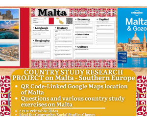
Country Study Research Project - Malta - Social Studies - South Europe
Social Studies, Geography, History, History: Europe, Grade 7, 8, 9, 10, 11, 12, Worksheets & Printables, Writing Prompts, Worksheets
Country Study Research Project - Malta - Social Studies Report - Southern Europe This Malta Country Study Research Project can be a perfect teacher tool box activity for your Geography and Social Studies classes, designed specifically for Middle School and High School students (Grades 7–12) . Suitable for Country Study Activities , this printable, 2-page PDF teaching resource engages learners to explore and endeepen important aspects and facts of Malta (Southern Europe). Use this Country Study Research Project on Malta to guide students through the process of building a comprehensive Country Study Report , while emproving their knowledge in areas such as geography, history, economy, language, and culture . Within this Malta Country Study Resource, Social Studies teachers can find the following geography activities: 🌍 Interactive Map Activity A QR code linking directly to Malta ’s location on Google Maps. 🏔️ Geography Questions Explore Malta ’s terrain, climate, and notable physical features. 📜 History Questions Investigate key events and historical figures that shaped Malta 's past. 🗣️ Language Exploration Learn about the official languages spoken in Malta : English + Maltese 💼 Economy Questions Analyze Malta ’s economic system, major industries, and current challenges. 🏙️ Capital City Focus Write about 7 important sights in Malta ’s capital city, Valletta 🏘️ Other Cities Identify and write about 5 additional cities across Malta 🎭 Culture Prompt Reflect on Malta ’s unique cultural identity within the Southern European region This Social Studies, Geography Country Study on Malta (Southern Europe) PDF Digital Teaching Resource (2 PDF Printable Slides) is ideal for Middle School and High School students from 7th grade to 12th grade to test Malta and its Culture At Social Studies with Alan , we’re committed to providing fun, high-quality resources that help teachers inspire curiosity and global awareness in the classroom. Because learning should always be engaging and memorable . ➡️ Explore more Social Studies & Geography teaching tools by clicking here: Learning with Alan
Author Learning with Alan
Rating
Tags Country Study, Social Studies, Report, Activity, Europe, Malta, Worksheets, Printable, History, Southern Europe
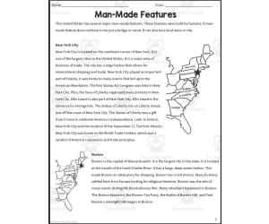
Man-Made Features Reading Packet
Social Studies, Geography, Grade 4, Worksheets & Printables, Worksheets
Man-Made Features Reading Packet: An Excellent Educational Tool Man-Made Features Reading Packet is an insightful and practical educational tool designed primarily for fourth-grade learners. No preparation needed, this resource takes a fun and engaging approach to geography by providing an informative passage and related vocabulary that students can readily apply within their learning environment. This product is perfect for both home school educators and public school teachers alike. It's ideal for social studies lessons focused on our world's human-created geographical features. The print-and-go pages conveniently fit into various instructional contexts like whole group class activities, small group projects or even as homework assignments. Packed with Interactive Activity Sheets The packet comprises of 11 ready-to-print pages delivered in PDF format. Each activity sheet fosters active learning while promoting critical thinking skills. They include multiple-choice questions, which offer learners an opportunity to self-assess their comprehension levels. Fostering Independent Learning: Through self-guided material exploration, the reading packet encourages independent learning among students. Gauging Learner Progress: The packets also aid teachers in effectively tracking learner progress. Included Answer Keys: Answer keys make it easier for educators to check work swiftly or guide conversation during review sessions. Incorporate Visual Representation Schemes Human-made geographical features are visually represented using graphic organizers within the packet– supporting students' better understanding of the concept. A Beneficial Mainstay Within Any Educational Context Be it face-to-face classroom instruction or remote teaching from home - This reading packet proves itself beneficial in teaching social studies and geography at a fourth-grade level. Opt for Man-Made Features Reading Packet – a resource equipping learners with meaningful insights into man-made geographic features, aiding teachers in fostering dynamic education endeavours seamlessly!
Author Sarah Miller Tech
Tags Geography, Social Studies, Human-created Features, Reading Packet, Comprehension
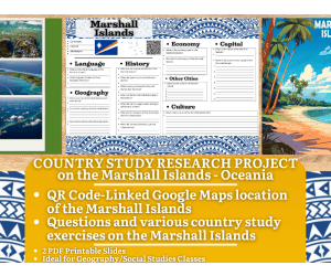
Country Study Research Project - Marshall Islands - Oceania
Social Studies, First Peoples (Native), Geography, History, Grade 7, 8, 9, 10, 11, 12, Worksheets & Printables, Worksheets
Country Study Research Project Worksheets - Marshall Islands - Social Studies Report - Oceania This Marshall Islands Country Study Research Project can be a perfect teacher tool box activity for your Geography and Social Studies classes, designed specifically for Middle School and High School students (Grades 7–12) . Suitable for Country Study Activities , this printable, 2-page PDF teaching resource engages learners to explore and endeepen important aspects and facts of the Marshall Islands (Oceania). Use this Country Study Research Project on the Marshall Islands to guide students through the process of building a comprehensive Country Study Report , while emproving their knowledge in areas such as geography, history, economy, language, and culture . Within this Marshall Islands Country Study Resource, Social Studies teachers can find the following geography activities: 🌍 Interactive Map Activity A QR code linking directly to Marshall Islands ’ location on Google Maps. 🏔️ Geography Questions Explore Marshall Islands ’ terrain, climate, and notable physical features. 📜 History Questions Investigate key events and historical figures that shaped Marshall Islands ' past. 🗣️ Language Exploration Learn about the official languages spoken in Marshall Islands : English + Marshallese 💼 Economy Questions Analyze Marshall Islands ’ economic system, major industries, and current challenges. 🏙️ Capital City Focus Write about 7 important sights in Marshall Islands ’ capital city, Majuro 🏘️ Other Cities Identify and write about 5 additional cities across Marshall Islands 🎭 Culture Prompt Reflect on Marshall Islands ’ unique cultural identity within the Oceanian region This Social Studies, Geography Country Study on Marshall Islands (Oceania) PDF Digital Teaching Resource (2 PDF Printable Slides) is ideal for Middle School and High School students from 7th grade to 12th grade to test Marshall Islands and its Culture At Social Studies with Alan , we’re committed to providing fun, high-quality resources that help teachers inspire curiosity and global awareness in the classroom. Because learning should always be engaging and memorable . ➡️ Explore more Social Studies & Geography teaching tools by clicking here: Learning with Alan
Author Learning with Alan
Rating
Tags Country Study, Social Studies, Report, Geography, History, Marshall Islands, Oceania, Worksheets, Activity, Project
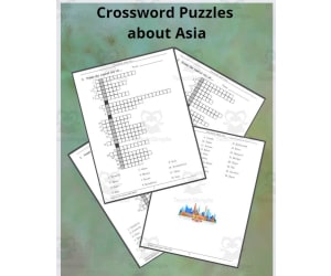
Crossword Puzzles about Asia
Social Studies, Geography, Grade 4, 5, 6, 7, Crosswords Puzzles, Worksheets, Worksheets & Printables
Crosswords about Asia. Mainly cities and capitals but also general knowledge.
Author TheBrightestKid
Tags Asia, Asian Countries, Asian Cities

Charles Lindbergh Reading Packet
Social Studies, Biographies, Grade 4, 5, Worksheets & Printables, Worksheets
This resource is a Charles Lindbergh Reading Packet. This is a great no prep resource that all you have to do is print and go! Students will love learning history as they read an informative passage and apply vocabulary terms. Worksheets included such as multiple-choice questions and graphic organizers will allow them to show what they know. These work well for social studies or reading instruction. Answer keys included.
Author Sarah Miller Tech
Tags Reading Packet, Charles Lindbergh, Biography, Graphic Organizer, History

Illinois Worksheet
Social Studies, History, History: USA, Grade 2, 3, 4, 5, 6, Worksheets & Printables, Worksheets
This Illinois Worksheet is a great way for students to organize and direct their research related to the state of Illinois. It's a great resource for teachers who want their students to have a well-rounded understanding of the state.
Author Have Fun Teaching
Tags States
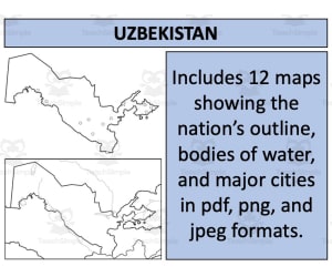
Uzbekistan Map Resources
Social Studies, Geography, Not Grade Specific, Homeschool Resources, Worksheets & Printables, Worksheets
Uzbekistan Map Resources Uzbekistan Map Resources is a detailed and versatile teaching aide designed to support educators in their mission to deliver engaging and accurate geography lessons. This offering targets teachers operating in both traditional public school settings as well as the growing community of homeschoolers, making this an adaptable tool for various learning environments. Detailed Contents The product presents twelve distinct map sheets provided in PDF, JPEG, and PNG formats for easy integration into lesson plans or presentations. These aren't just simple outlines ; you'll find maps detailing bodies of water, major settlements and comprehensive graphical representations that put Uzbekistan into context with its neighboring nations. It's a diverse assortment sure to accommodate multiple teaching styles and methods. Aimed Crowd: While not attached to a specific grade level, the material within can comfortably suit varying degrees of study difficulty depending on the discretion of the educator. The primary subject covered here falls under Social Studies with Geography being a key subcategory—ideal for educators aiming to provide their students with a well-rounded understanding of global cultures and landscapes. This package lends itself flexibly; users are permitted to incorporate these maps into their own educational resources when instructions on the preview sheet are adhered to—a significant help when tailoring instructional materials uniquely suited towards individual student needs or class-specific lesson plans. Ready your students for their virtual journey through Uzbekistan using visually appealing supporting materials from our readily available social studies portfolio today!
Author Mr Gray History
Tags Uzbekistan, Geography, Map Resources, Social Studies, Homeschooling

Hawaii State Symbols Interactive Foldable Booklets - EBOOK
Social Studies, Geography, Preschool, Grade 1, 2, 3, 4, 5, 6, 7, 8, Worksheets & Printables, Worksheets
Hawaii State Symbols Interactive Foldable Booklets - EBOOK The Hawaii State Symbols Interactive Foldable Booklets - EBOOK is a comprehensive teaching resource that aids educators in their efforts to teach everything about the state symbols of Hawaii. It comes with two booklets, one in color and the other in black & white, providing variety and customization based on your needs. Versatile Learning Tool Ideal for classroom-based learning to homeschool setups. Versatile for conducting either whole group lessons or small group activities. An excellent individual study material or homework assignment. Contents Filling Fill out each foldable booklet with information about the following: Hawaii state map, Hawaii Flag, The state Flower, Bird of the particular state etc. , In addition, a blank page is included where extra information can be added by teachers or students alike. Note:This eBook works well alone as an activity but also complements any interactive notebook or lapbook your class might already have. All twelve pages come in downloadable PDF file format making printing quite efficient — just cut, fold glue and let the learning begin! Aimed at Grades K-8 Learners: designed specifically keeping grades K-8 learners into consideration catering heavily towards social studies under geography subtopics while being respective enough towards grade levels 7 and 8. America Awaits—Collect Em' all! Why limit learning to just one state! Broaden your horizons—aim for the whole of America by collecting all the booklets representing every single American State.
Author Knowledge Box Central
Tags Hawaii, State Symbols, Interactive, Foldable Booklets
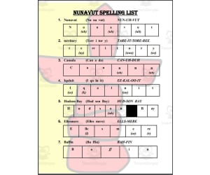
Nunavut (Canada) Spelling List
Social Studies, History, History: Canada, Not Grade Specific, Worksheets & Printables, Worksheets
Expanding Vocabulary of Canada's Arctic Territory\nThe Nunavut Spelling List introduces students to key vocabulary related to Canada's Arctic territory and newest province, Nunavut. With 13 essential words and definitions, this resource builds students' knowledge of important Canadian geography.\n\nThe spelling list focuses on Nunavut's largest communities, land regions, bodies of water, as well as the indigenous Inuit people. Engaging syllabification and phonetic spellings help students properly pronounce more complex terms like "archipelago" and "Inuktitut". Three bonus words related to Inuit language and culture provide further enrichment. \n\nDetailed word definitions on a separate page aid retention and understanding. This vocabulary builder encourages students to explore the unique landscapes, wildlife, traditions that shape Canada's massive northern territory. \n\nThe Nunavut Spelling List's clear presentation and focused vocabulary set make it easy to implement across various classroom contexts and instructional approaches.
Author Mr. Matthews Teacher Store
Tags Nunavut, Canada, Arctic, Inuit, Spelling

The American Colonies Worksheet
Social Studies, History, History: World, Not Grade Specific, Worksheets, Worksheets & Printables
This The American Colonies Worksheet is perfect for students who have read A Colonial Life. With this worksheet, students can write and draw about the colonies. This is a great way for students to learn more about the colonies.
Author Have Fun Teaching
Tags America, History

Countries of the World: Spain Interactive Foldable Booklets - EBOOK
Social Studies, Geography, Grade 2, 3, 4, 5, 6, 7, 8, 9, 10, 11, 12, Worksheets & Printables, Worksheets
Countries of the World: Spain Interactive Foldable Booklets - EBOOK This comprehensive educational resource is aimed at engaging diverse learning styles. Spanning a total of 26 PDF pages, this product offers an expansive journey into the captivating country - Spain. Target Audience & Application Suitably designed for Grade 2 to Grade 12 learners, it aids educators and homeschoolers with a dynamic tool that can be easily incorporated into whole group instruction, small study groups or given as an assignment to students. A perfect fit for Social Studies curriculum with particular focus on Geography. A Unique Interactive Approach Economic Facts: It covers intriguing details about the economy of Spain. Government Structure & Operations: Gain insights into how government operates in Spain and its structure. Cultural Insights:: Get enlightened about Spanish culture and their way of life. Geography:: Acquire knowledge about geographical facts. Beyond merely receiving information, these booklets engage learners actively allowing them to cut out, fold together, and decoratively color their individual booklets themselves resulting in personalized keepsakes from their national studies exploration. Innovative Learning Approach Over Traditional Methods This distinctive eBook facilitates factual understanding combined with imaginative activities promoting task-based comprehension that makes classroom learning stimulating leading towards better long-term retention outcomes. All in all,, this eBook stands out from regular teaching resources by guiding deeper content-engagement through interactive mediums making seasoned teachers' dynamic pedagogical expertise come alive within every classroom or home-based study arena.
Author Knowledge Box Central
Tags Spain, Interactive Learning, Foldable Booklets, Geography, Social Studies

Stonehenge Dot-to-Dot / Connect the Dots PDF
Creative Arts, Social Studies, Math, Middle School, Homeschool Resources, High School, Elementary, Worksheets & Printables, Worksheets, Dot To Dots
Connect 396 dots to complete the Stonehenge Extreme Difficulty Dot-to-Dot / Connect the Dots Puzzle! Dot-to-dots such as this one are a relaxing activity that can both educate and entertain kids. They can be given to students in a wide range of ages, from early elementary school, to middle school and even high school. They’re also handy for homeschooling. These challenging puzzles can help improve fine motor skills, and also help kids develop patience and focus. Finally, they’re fun to color too! Let the kids grab some crayons or colored pencils and put a personal touch on their dot-to-dot. This dot-to-dot printable created by Tim van de Vall and is copyright Tim’s Printables LLC. Terms of use: May be printed/downloaded for personal and educational purposes only. The connect the dots is activity on page 1, and the answer key is on page 2. The page dimensions are: 8.5”x11”. PDF format.
Author Tim's Printables
Rating
Tags Stonehenge, Prehistory, England, Europe, Dot To Dot, Connect The Dots, Connecting The Dots, Worksheet, Activity, Printable

Entrepreneurship in Latin America Reading Packet
Social Studies, Economics, Grade 6, Worksheets & Printables, Worksheets
Entrepreneurship in Latin America Reading Packet is an informative resource for middle school students to learn about business and economics in Latin America. Students will read a passage and apply key vocabulary terms related to entrepreneurship. This printable packet includes reading comprehension questions, graphic organizers , and answer keys. Educators can use this as a no-prep lesson for social studies or reading classes. It works well for whole-group instruction, small group work, or as an independent homework assignment. By engaging with the real-world content, students will build their literacy skills and understanding of economic concepts. This concise packet simplifies a complex topic so students can learn meaningful lessons about international business.
Author Sarah Miller Tech
Tags Latin America, Economics, Government, Entrepreneurship, Graphic Organizers

Deposition Worksheet
Social Studies, Science, Earth and Environmental Sciences, Earth Sciences, Grade 2, 3, 4, 5, Worksheets & Printables, Worksheets
This Deposition Worksheet will help your students understand how sediments and rocks are deposited by different natural means. It's a great resource for teachers looking to help their students better understand geology.
Author Have Fun Teaching
Tags Landforms, Rocks

All About Influential Leaders | February Writing Packet
ELA, Social Studies, Writing, Biographies, Grade 3, 4, 5, Worksheets & Printables, Worksheets
This is a February Writing Packet for students. This writing packet focuses on people born in February. Some of these people may be familiar to students and others may be unfamiliar. Students will get to learn about these important figures and apply their knowledge through writing. There are 2 PDFs included. One of the PDFs is a set of Note Taking Foldables. The teacher and students can: 1. Choose a HISTORY MAKER to research by reading a book, watching a video, or using Pebble Go. 2. Print HISTORY MAKER page front and back. 3. Take notes and color. 4. Optional: Glue into journal for future reference. The biographies included in the Note Taking Foldable packet are: 1. Susan B. Anthony 2. Marian Anderson 3. Langston Hughes 4. Thomas Edison 5. Babe Ruth 6. Abe Lincoln 7. Michael Jordan 8. Rosa Parks 9. Levi Strauss 10. Mo Willems As students complete their research, they will be able to use these foldables to take notes along the way. You can encourage students to highlight things such as birthdays, their accomplishments, their values, their family, etc. The second PDF is a Mini Chapter Book packet. Students will be able to apply what they learned during the Note Taking process and develop their own chapter book biographies. The individuals included in this PDF are: 1. Marian Anderson 2. Abe Lincoln 3. Michael Jordan 4. Rosa Parks 5. Levi Strauss 6. Mo Willems The teacher and students will: Choose what level of writing paper you want to use. Choose the history maker of study. Print history maker cover and chapter 1 page back to back. Print chapters 2 and 3 back to back. Fold and staple. 6 Best if used with note taking pages.
Author Moffat's Travels
Tags Mini Books, Chapter Books, Biographies, Influential Leaders, Black History, February, Winter, Mo Willems, Grammar, Literacy Center
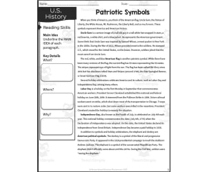
Patriotic Symbols Reading Packet
Social Studies, History, History: USA, Grade 5, Worksheets & Printables, Worksheets
This resource is a Patriotic Symbols Reading Packet. This is a great no prep resource that all you have to do is print and go! Students will love learning history as they read an informative passage and apply vocabulary terms. Worksheets included such as multiple-choice questions and graphic organizers will allow them to show what they know. These work well for social studies or reading instruction. Answer keys included.
Author Sarah Miller Tech
Tags U.S. History, Patriotic Symbols, Cross-curricular, Graphic Organizers, Text Structure

Who What When Where Why Summary Graphic Organizer Worksheet
ELA, Social Studies, Reading, Grade 2, 3, 4, Teacher Tools, Graphic Organizers, Worksheets & Printables, Worksheets
This Who What When Where Why Summary Graphic Organizer Worksheet is a great way for your students to think about the information they have just learned. It can help them organize their thoughts and remember what they have learned.
Author Have Fun Teaching
Tags Note Taking, Story Elements, What Is A Summary Worksheet

Iraq Spelling List
Social Studies, History, History: Asian, Not Grade Specific, Worksheets & Printables, Worksheets
The Iraq Spelling List product introduces students to key vocabulary related to the country of Iraq. With 13 total words included in the spelling list, students will expand their knowledge of Iraqi geography, culture, and history. The product contains the list of 10 regular words like Iraq, Baghdad, Mosul, and Kirkuk along with syllables and sound spellings to help students properly pronounce each term. An additional 3 bonus words connected to Iraq are also included, featuring the Tigris and Euphrates rivers as well as background on the Syrian Desert. An accompanying vocabulary page provides detailed student-friendly definitions for all 13 spelling list words. Educators can implement this versatile resource in whole group, small group, or independent learning settings to build student literacy skills while making connections to social studies content.
Author Mr. Matthews Teacher Store
Tags Iraq, Spelling, Vocabulary, Literacy, Social Studies
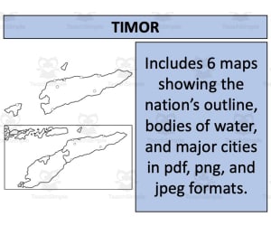
Timor Map Resources
Social Studies, Geography, Not Grade Specific, Worksheets & Printables, Worksheets
Timor Map Resources Timor Map Resources offers educators an invaluable tool for teaching geography. This package includes a comprehensive set of map sheets showcasing the geographical layout of Timor in different detail levels and formats. These maps are not grade specific, which implies that they can be utilized across various educational standards. The resource contains six unique map sheets provided in universally accessible formats such as PDF, JPEG, and PNG. These different versions provide flexibility and convenience ensuring the maps can easily fit into any presentation or teaching material. Different Perspectives: Each distinct map sheet presents a specific perspective of Timor's geography to foster learners' understanding through clear visualization. They feature blank outlines for creative usage or testing knowledge retention, bodies of water for explaining aquatic ecosystems, and significant settlements providing social studies context. Beyond Borders: Ones standout aspect is that this resource takes learning beyond borderlines by presenting Timor both statically and dynamically within its surrounding nations' context. Extendable Utility: What allows these resources to shine brighter is their extendable utility—educators can incorporate these maps into their original materials following simple instructions presented on the preview sheet systemizing this process taking away potential Hassles. In essence, with these deeply detailed yet flexible resources offered in widely usable file types (zip files), you receive a great range offering rich geographical insights at your fingertips; ready-to-use just clicks away! Note: The use-case scenarios suggested here are subject to users following instructions explicitly mentioned ensuring credibility isn't compromised while enhancing pedagogical impact simultaneously using our conscientiously crafted educational products benefiting diverse user needs optimally without restrictions significantly!
Author Mr Gray History
Tags Timor Geography, Map Resources, Teaching Aid, Educational Material, Social Studies
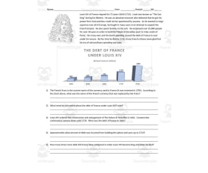
The Debt of France Under Louis XIV | Comprehension Questions
Social Studies, History, History: Europe, Grade 9, 10, 11, 12, Worksheets & Printables, Worksheets
This resource is a comprehension worksheet for The Debt of France Under Louis XIV. Students will read a short passage and then complete 5 short answer questions. Answer key included.
Author DrDrew
Tags Debt, France, Europe, History, Louis XIV
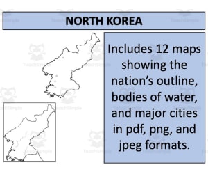
North Korea Map Resources
Social Studies, Geography, Not Grade Specific, Worksheets & Printables, Worksheets
North Korea Map Resources - An Educational Tool This versatile teaching aid, primarily designed for public school teachers and homeschoolers, is not restricted by grade levels. A focus on North Korea's geography makes it a fitting accessory for Social Studies and relevant learning areas. Comprehensive Map Pack It comprises twelve map sheets in PDF, JPEG, and PNG formats. The collection provides diverse views of North Korea - blank layouts for creative exercises or testing geographical knowledge, maps showing bodies of water suitable for environmental studies or physical geography sessions, and depictions featuring major urban settlements enlightening learners about the country's development trajectory. The pack also includes detailed maps to present North Korea within a global context aiding foreign relations studies along with an isolated portrayal helpful during specific classroom activities or discussions about the nation. User-Friendly Access This product comes with an easy-to-follow use policy allowing buyers to incorporate the purchased maps into their own products 'North Korea Map Resources’ is well-rounded teaching aid conceived with varied pedagogic approaches in mind to ensure maximum learner engagement while enabling educators effectively deliver important geographical knowledge concerning North Korea. This North Korea Map Resources is a ready to print and use resource!
Author Mr Gray History
Tags North Korea, Geography, Map Resources, Social Studies, International Relations

Vehicle Words Worksheet
Social Studies, ELA, Language Development, Vocabulary, Preschool, Grade 1, 2, Worksheets & Printables, Worksheets
This Vehicle Words Worksheet is perfect for helping students match words to vehicle pictures. This is a great resource for teachers who want to help their students learn more about transportation.
Author Have Fun Teaching
Tags Have Fun Teaching