Country Study on Ireland - Geography Presentation



- Grades
- Grades 7–10, High School, Middle School
- Pages
- 15
- File type
- Preparation
- Print ready


- Subject
- Social Studies, History, History: Europe, Geography
- Topic
- Country Study, Social Studies
- Resource types
- Teacher Tools, Presentations
- Preparation
- Print ready
About this resource
What's inside this resource
Country Study on Ireland - Europe - Geography + Social Studies Presentation
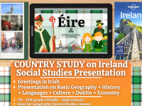
Bring Ireland to life in your classroom with this Introductory Teaching Resource on Ireland, designed for Geography, European History (Northwestern Europe), and Social Studies. Ideal for Grades 7–12 (Middle School and High School), this PDF digital presentation is informative, visually engaging, and requires little to no preparation.
Students will explore Ireland’s geography, history, culture, language, and economy, making this resource perfect for country studies and introductory lessons in Geography and Social Studies.
📘 Within this Social Studies and Geograhy Presentation Lesson, teachers and educators can find the following topics included:
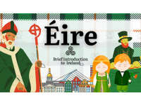
✅ Greetings in Irish Language
✅ Geography of Ireland (Northwestern Europe)
Key facts, bordering countries, and an interactive Google Maps link✅ Quick Facts
Population, population density, capital city, currency, government, and more✅ History Overview
A clear and concise summary of Ireland’s most important historical events (Northwestern Europe)✅ Geography, Climate & Environment
Land area, regions, and climate zones✅ Ireland’s Economy
Major industries, exports, and economic strengths✅ Dublin
Ireland’s capital city, including famous landmarks and cultural highlights✅ Other Major Cities
A map highlighting key urban centers across Ireland (Northwestern Europe)✅ Culture & Traditions
Customs, values, and traditions that shape Ireland's society (Northwestern Europe)✅ Goodbye in Irish Language
This Social Studies + Geography Country Study Presentation on Ireland (Northwestern Europe) PDF Digital Teaching Resource (14 slides) can be more than great for Middle School and High School Students from 7th grade to 12th grade to introduce Ireland (Northwestern Europe) and its culture, language, society, history and economy.
Learning with Alan is a Teaching Resource - Educational Material Store whose aim is to help Teachers, Educators and Tutors to achieve their teaching objectives while creating a fun and stimulating environment. Learning should always be fun. Never Forget!
If you want to browse more of my Teaching Resources, click here Learning with Alan!!
Related resources
More resources teachers may find useful
24 related resources were found using this product's title, contributor, categories and tags.


In the classroom
Teaching tips & learning objectives

Learning objectives
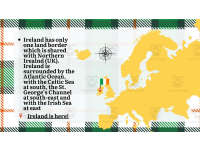
Locate Ireland in north-western Europe and name the seas and the single land border that surround it
Recall key national facts about Ireland, including its capital, two official languages, government type, and currency
Sequence major events in Irish history from the arrival of the Celts to the Good Friday Agreement

Teaching tips
Teach the greeting slides as bookends — have the class say Dia Dhuit together at the start of the lesson and Slán at the end
Turn the two history slides into a timeline task: the twenty dated events span roughly 2,500 years and are already summarised one line each
Use the economy pie chart for cross-curricular percentage reading — tertiary 60.2%, industry 38.6%, primary 1.2%

Skills covered
Map reading — students locate Ireland relative to Northern Ireland, the Atlantic Ocean, the Celtic Sea, St. George's Channel, and the Irish Sea, and find Dublin, Galway, and Cork on a cities map.
Historical sequencing — twenty dated events from the Celts (c. 500-300 BCE) to the Good Friday Agreement (1998) give students a ready-made chronology of Irish history to order and discuss.
Data interpretation — a pie chart splits Ireland's economy into tertiary (60.2%), secondary (38.6%), and primary (1.2%) sectors for students to read and compare.
Good to know
Questions teachers ask about this resource
Does the presentation cover Northern Ireland as well as the Republic?
The focus is the Republic of Ireland. Northern Ireland appears where the content calls for it: as Ireland's only land border, and in history entries such as the Plantation of Ulster, the 1921 Anglo-Irish Treaty and partition, and the Good Friday Agreement.
Which Irish-language phrases do students pick up along the way?
The deck opens with Dia Dhuit (hello) and closes with Slán (goodbye), and a dedicated vocabulary slide adds Tá (yes), Níl (no), Go raibh maith agat (thank you), and Conas atá tú? (how are you?).

No reviews yet
Downloaded this resource? Tell other teachers how it went.
Resource details
Concepts & topics
Core concepts
 Core concepts
Ireland
European geography
Irish history
Country study
 Topics
Explore more
Categories this resource belongs to
Explore related searches
More to explore
You may also like