2,800 products added recently
Page 629 - Newest Teaching Resources
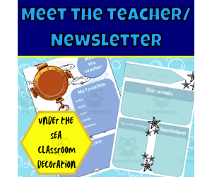
Under the sea meet the teacher and newsletter templates
, Not Grade Specific, Templates, Teacher Tools
The best part about decorating your classroom with this Under the Sea Meet the teacher and newsletter templates is picking and choosing your favourite designs that best appeal to your students, the idea behind this classroom decoration is to give you as a teacher the opportunity to pick your favorited under the sea inspired designs to create your very own masterpiece of a classroom. This Under the Sea Meet the teacher and newsletter template is to create a great classroom community, these templates help create a class theme. The templates can be used for your meet the teacher and can be sent out to parents or printed and stuck up on the door. The newsletter templates can be used to let parents and students what is up and coming in the week to come while sticking to your class theme. This Under the Sea meet the teacher and newsletter template download the PDF print in full-color laminate and paste it on walls or sent out to parents. These posters are suitable for all grades however in specific pre-k as well as grades; R,1, 2 and 3. If you like this Under the Sea meet the teacher and newsletter template classroom decoration be sure to have a look at the rest of this edition's decoration: Number posters - Alphabet posters - Birthday chart - Daily Calendar - Focus wall - Voice level posters - Months of the year - Days of the week - Color posters This download contains a total of 12 pages DIRECTIONS: The files are all PDFs. Print and laminate the pages to use in the classroom. If you would like anything specific to be added please let me know and I’ll be happy to do so when I am able to. Use: You are free to use and modify the material. For similar or other resources, visit my store here!
Author Ezee 101
Tags Classroom Community, Classroom Theme, Class Teme, Class Newsletter, Meet The Teacher, Under The Sea
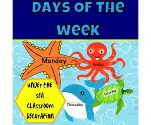
Under the sea days of the week
, Kindergarten, Preschool, Grade 1, 2, 3, 4,
The best part about decorating your classroom with this Under the Sea days of the week is picking and choosing your favorited designs that best appeal to your students, the idea behind this classroom decoration is to give you as a teacher the opportunity to pick your favorited under the sea inspired designs to create your very own masterpiece of a classroom. This Under the Sea days of the week decoration is a key element in creating a classroom community as well as classroom management within your class. The objective behind the days of the week is to create an emergent reading-rich environment. This Under the Sea days of the week download the PDF print in full-color laminate and paste it on walls. These posters are suitable for all grades however in specific pre-k as well as grades; R,1, 2 and 3. If you like this Under the Sea Days of the Week classroom decoration be sure to have a look at the rest of this edition's decoration: Number posters - Alphabet posters - Birthday chart - Daily Calendar - Focus wall - Voice level posters - Months of the year - Days of the week - Color posters This download contains a total of 35 pages DIRECTIONS: The files are all PDFs. Print and laminate the pages to use in the classroom. If you would like anything specific to be added please let me know and I’ll be happy to do so when I can. Use: You are free to use and modify the material. For similar or other resources, visit my store here!
Author Ezee 101
Tags Classroom, Classroom Decor, Decoration, Under The Sea, Days Of The Week, Classroom Labels, Emergent Reading, Literacy Enriched

Under the sea months of the year
, Kindergarten, Preschool, Grade 1, 2, 3, 4, 5,
The best part about decorating your classroom with this Under the Sea months of the year is picking and choosing your favourite designs that best appeal to your students, the idea behind this classroom decoration is to give you as a teacher the opportunity to pick your favourite under the sea inspired designs to create your very own masterpiece of a classroom. This Under the Sea months of the year decoration is a key element in creating a classroom community as well as classroom management within your class. The objective behind the student labels is to create an emergent reading-rich environment. This Under the Sea months of the year download comes as a downloadable pdf which you can print in full color and laminate. These posters are suitable for all grades however in specific pre-k as well as grades; R,1, 2 and 3. If you like this Under the Sea months of the year classroom decoration be sure to have a look at the rest of this edition decoration: Number posters - Alphabet posters - Birthday chart - Daily Calendar - Focus wall - Voice level posters - Months of the year - Days of the week - Color posters This download contains a total of 21 pages DIRECTIONS: The files are all PDFs. Print and laminate the pages to use in the classroom. If you would like anything specific to be added please let me know and I’ll be happy to do so when I am able to. Use: You are free to use and modify the material. For similar or other resources, visit my store here!
Author Ezee 101
Tags Classroom Decor, Decoration, Under The Sea, Months Of The Year, Emergent Reading, Classroom Labels
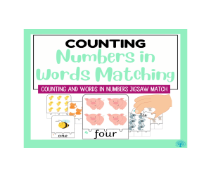
Numbers in Words Counting Jigsaw
Math, Early Math, Numbers, Kindergarten, Preschool, Grade 1, Activities
Mastering number words and developing counting skills are key kindergarten math standards. These Numbers in Words Counting Jigsaws provide a hands-on way to practice these foundational concepts. Learning numbers in words is a multifaceted skill that benefits language development, mathematical understanding, and practical communication. It is an integral part of literacy and numeracy, providing individuals with the tools they need for effective communication and problem-solving in various contexts. This resource includes 10 printable counting puzzles. The top half of each jigsaw features pictures of animals like bees, chicks, pigs and cats. Students count the pictures and then attach the correct puzzle piece showing the number word that matches the quantity below. For example, if a page shows 5 cats, the student would attach the puzzle piece labeled "five." Connecting the visualized quantities to the correct written number word reinforces rote counting ability and strengthens number word recognition. Kids will love the hands-on practice assembling the counting puzzles! These engaging activities are perfect for math and literacy centers , small group instruction, and morning work. Teachers can also use them to assess number word knowledge and counting skills in an interactive way. With their multimodal approach, these Counting Jigsaws offer essential practice with core early math concepts kids need to know. The eye catching clipart is courtesy of Kari Bolt Clipart.
Author SEN Resource Source
Tags Counting, Numbers, Sorting And Matching, Early Math, Numbers 1-10

Under the sea cursive alphabet posters wave edition
, Not Grade Specific, Posters, Classroom Decor
Under the Sea Cursive Alphabet Posters (Wave Edition) Transport students into an underwater world with these fun cursive alphabet posters! The 26 posters feature adorable sea creatures like sharks, seahorses, and octopuses forming each upper and lowercase cursive letter. Display the colorful designs around your classroom to help reinforce letter recognition and cursive handwriting skills. Use the posters during small group lessons for struggling readers or independent writing activities. This complete set allows flexibility to highlight particular letters each week. Print, laminate, and hang for years of learning and decoration! See coordinating number, calendar , and behavior management posters to fully immerse your classroom under the sea!
Author Ezee 101
Tags Classroom Decoration, Alphabet, Alphabet Posters, Cursive Writing, Cursive, Waves
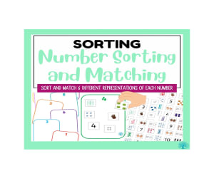
Number Sorting and Matching for Numbers 1-10
Math, Early Math, Numbers, Preschool, Kindergarten, Grade 1, Activities
Building number sense through hands-on exploration is key in early childhood math. These Number Sorting and Matching activities allow kids to concretely connect numeral symbols, quantities and representations in an engaging way. This set includes 10 colorful number boards numbered 1-10. Each board has space to place the matching image cards - dienes, numicon pieces, dice, cubes, and counting fingers cards numbered 1-10. By sorting and matching the images to the correct numeral, students reinforce the symbolic, quantity and visual relationships. The tactile experience helps cement foundational number concepts. Kids will gain intuition for relative magnitude as they see that numbers with more dots or cubes are greater. The versatile activities can be used in small groups, centers and whole class instruction. Teachers can assess understanding of numerals, counting skills and number relationships. Students will love the hands-on practice manipulating the pieces! Providing concrete ways for students to explore numbers sets them up for math success. This Number Sorting and Matching set is a must-have for reinforcing essential number sense. Early childhood educators will love having these durable, versatile math manipulatives! For continues use i recommend laminating the boards and cards and then using velcro to place them. The clipart images are courtesy of Arty Clips Graphics.
Author SEN Resource Source
Tags Numbers, Counting, Sorting, Matching, Early Math

Number Bonds to 10
Math, Addition and Subtraction, Addition, Early Math, Numbers, Preschool, Grade 1, Activities
Gaining number sense and fluency with basic math facts is crucial for future math success. These hands-on Number Bonds to 10 activities make practicing this foundation skill fun and engaging! Here are some key reasons why mastering number bonds to 10 is important: Foundation for Basic Arithmetic: Number bonds to 10 form the foundation for basic arithmetic operations. Understanding how numbers can be combined to make 10 provides a solid basis for addition, subtraction, multiplication, and division. Mental Math Skills: Number bonds to 10 facilitate mental math calculations. Being able to quickly decompose and recompose numbers helps in mentally solving math problems, which is an essential skill for efficiency in calculations. Number Sense: Developing a strong sense of numbers is crucial in mathematical understanding. Number bonds help children grasp the relationships between numbers and how they can be manipulated, fostering a deeper comprehension of numerical concepts. Problem-Solving: Number bonds support problem-solving skills. When faced with mathematical problems, individuals can use their knowledge of number bonds to make connections and find solutions more effectively. Early Algebraic Thinking: Understanding number bonds lays the groundwork for early algebraic thinking. It introduces the concept of breaking numbers into parts and helps children recognize the inverse relationship between addition and subtraction. Mathematical Fluency: Mastering number bonds to 10 contributes to mathematical fluency. Fluent mathematicians can work with numbers effortlessly, which is crucial as more advanced mathematical concepts are introduced. Real-World Applications: The ability to quickly recognize and manipulate numbers up to 10 has practical applications in everyday situations. From counting objects to dividing items into groups, this skill is valuable in various real-world scenarios. Building Confidence: Success in understanding number bonds to 10 builds confidence in young learners. It provides a sense of accomplishment and encourages a positive attitude towards mathematics. The set includes a printable worksheet featuring cute popcorn pots numbered 0-9. Students cut out the matching popcorn top pieces numbered 1-10 and glue them onto the pots to create number bonds equaling 10. For example, they'll match the pot labeled "7" with the top "3" to form 7+3=10. Creating the popcorn number pairs reinforces understanding of part-part-whole relationships and builds instant recall of addition facts. Students strengthen mental math, number bonds and fact families in an interactive way. The concrete popcorn pieces also provide helpful visual and tactile learning cues. These Number Bonds worksheets are perfect for math centers , morning work, fact fluency practice and developing conceptual understanding. Assembly style activities allow for easy self-checking as students create the number pairs. Kids will enjoy the hands-on practice! With their playful popcorn theme and hands-on format, these Number Bonds to 10 printables provide the engaging repetition needed to master essential number sense. They are a sweet addition to any primary classroom math curriculum.
Author SEN Resource Source
Tags Number Bonds, Counting, Addition, Early Math, Counting To 10, Bonds To 10

Sequencing Activities
ELA, Special Resources, Language Development, Pre-Reading, Speech Therapy, Special Education Needs (SEN), Not Grade Specific, Activities
Mastering the ability to sequence events in chronological order is an essential early reading skill. This set of Sequencing Activities provides engaging practice with ordering events and retelling stories through pictures. The set includes 12 worksheets featuring colorful illustration sequences of everyday activities and natural processes. Each page contains 4-5 pictures that students must put in the proper logical order by cutting and sticking them. Sequencing challenges include eating an apple, blowing up a balloon, a chick hatching, a seed growing, a spider weaving a web, doing laundry, making a bed, making cereal, making a sandwich, washing dishes, making a sundae and the life cycle of a frog. Placing pictures in the correct sequential order strengthens comprehension, storytelling skills and awareness of logical connections. Sequencing pictures is also a useful tool to support children practiving speech and language skills. Students must analyze the series of events and understand cause and effect relationships to complete the sequences accurately. These activities develop critical thinking in a fun, hands-on way. These Sequencing Activities are perfect for ELA centers , morning work, group instruction and developing storytelling abilities. Teachers can also use the sequencing sheets to assess students' skills in ordering events and making connections through pictures. With their engaging themes, these activities provide sequencing practice kids will love! The wonderful clipart comes courtesy of Kari Bolt clipart and Dancing Crayon Designs.
Author SEN Resource Source
Tags Sequencing, Sequential Tasks, Pattern Recognition, Sequence Cards, Story Sequencing
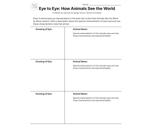
Eye to Eye How Animals See the World
Science, Life Sciences, Animals, Basic Science, Grade 3, 4, 5, 6, Teacher Tools, Lesson Plans
Description: During this lesson, children will examine, read about, and watch animal eyes in action as they learn more about the designs and functions of different eyes. They will create a model of an animal’s eye and present what they know about it to their friends, family, or class. Learning objectives I can… Describe different designs of animals’ eyes. Describe different functions of animals’ eyes. Create a realistic model of an animal’s eye. Teach someone else about a unique animal eye. Outline Build Interest: 1 photo discussion activity Read: 1 book and additional book & online options Draw: 1 realistic eye drawing activity and response Watch: selection of 5 video options (3:00-9:00 min/each) Model: 1 realistic eye model project Present: 1 preparation and presentation activity Debrief/Assess: 1 set of questions Glossary: 1 set of terms Suggested Extension Activities: 2+ activities Time needed: 2 - 4 hours Grade levels: 3rd - 6th Subject: Science Next Generation Science Standards: SCI 3-LS4-2. Use evidence to construct an explanation for how the variations in characteristics among individuals of the same species may provide advantages in surviving, finding mates, and reproducing. 4-LS1-1. Construct an argument that plants and animals have internal and external structures that function to support survival, growth, behavior, and reproduction.
Author Sprout & Inspire
Tags Animals, Eyes, Animal Features, Animal Science

Shape Sorting Activity
Math, Early Math, Geometry, Kindergarten, Preschool, Activities
Sorting shapes builds important early math skills like recognizing attributes, making comparisons and identifying patterns. This Shape Sorting Activity set provides engaging hands-on practice with 2D shapes that kids will love. The set includes 6 colorful shape sorting boards, each featuring a different shape in a variety of bright colors. Shapes include classics like circle, square, triangle and rectangle, as well as more advanced hexagons and pentagons. To play, students simply match the removable foam shapes to the correct silhouettes on the boards. The self-correcting format allows children to check their own work, building confidence. Kids will have a blast sliding the pieces into place as they learn to identify sides, angles and attributes of each distinct shape. Sorting the shapes exposes students to essential geometric vocabulary and concepts. The various shape, size and color patterns boost critical thinking as children analyze how to sort each piece. This activity set is ideal for math centers , small group instruction, and independent practice. With their hands-on, engaging format, these Shape Sorting boards provide the focused repetition little learners need to master shape recognition and attributes. Early childhood educators will love having this versatile set in their math manipulative toolkit! For continued use i would recommend laminating the boards and shapes and then using velcro to place them.
Author SEN Resource Source
Tags 2d Shape, Sorting, Matching, Math, Early Math, Shape Recognition, Hands-on Learning, Shape Identification, Shape Matching

Home Visual Timetable
Special Resources, Life Skills, Special Education Needs (SEN), Social Skills, Not Grade Specific, Worksheets & Printables, Flashcards
Establishing consistent routines is key for helping children feel secure and behave positively. This Home Visual Timetable set makes it easy for parents to create picture schedules that provide stability and structure. The set includes 114 colorful cards illustrating daily activities like wake up, get dressed, eat breakfast, brush teeth and more. Parents can use these picture cards to build customized schedules for their child's routines. Displaying a consistent visual timetable allows children to see the sequence of their day in a clear, predictable format. Children know what to expect and what comes next, reducing anxiety and behavioral issues. The picture cues also promote independence by allowing kids to check the schedule and transition between activities . Parents can work with therapists, counselors and teachers to create an appropriate timetable meeting the child's needs. Having matching picture cards used at home and school provides consistency across environments. Kids will thrive with this level of nurturing structure. An absolute must-have for promoting compliance, cooperation and organization, this Home Visual Timetable set is perfect for children on the autism spectrum or with communication, sensory processing or behavioral disorders. Simple to implement, these cards help instill healthy habits that set children up for daily success. The wonderful clipart is courtesy of Kari Bolt Clipart.
Author SEN Resource Source
Tags Visual Timetable, Parents, Autism, SEN, Special Needs, Schedule, Daily Routine, Routine Chart, Daily Schedule

0-10 Number Lines
Math, Number Lines, Early Math, Numbers, Kindergarten, Preschool, Grade 1, Worksheets & Printables, Flashcards
Reinforcing number sequence and improving number sense just got a lot more engaging with these vibrant 0-10 Number Lines! This set includes printable number lines in three fun designs perfect for math centers , activities or display. Using these number lines as support can help children gain some independence in their math work. The first set features numbers 0-10 depicted as adorable monster characters, with each numbered monster shown in a different color. The visual pairing of number and monster builds number recognition and sequencing skills. The second design provides traceable number line models from 0-10. Students can practice writing numerals and reinforcing order and value relationships as they trace over each number in sequence. This provides helpful repetition and writing practice. The third set displays numbers 0-10 in a spectrum of bright rainbow colors. This connects each numeral visually with its place in the sequence. Students will gain intuition for number order and patterns. These three number line designs allow teachers to match activities to the specific needs of learners. The different formats provide versatility for modeling counting, comparing numbers, skip counting, identifying missing numbers and more. This collection is ideal for centers , math journals, displays and reference. The wonderful and eye catching monster number Clipart images are courtesy of Pretty Grafik
Author SEN Resource Source
Tags Number Lines, Math, Number, Counting, Addition, Visual Aid, Early Math

Picture Prompt Reading Comprehension
ELA, Special Resources, Reading, Special Education Needs (SEN), Preschool, Grade 1, 2, Activities
Boosting reading comprehension skills is easy with these engaging Picture Prompt activities! This set includes 13 illustrated worksheets that challenge students to read and follow written directions carefully. Each page features a basic line drawing along with a set of instructions. Students must read the instructions closely to identify what objects to add to the picture, as well as how to color, size or place it. For example, one prompt instructs students that "In the vase there are 2 yellow flowers" this tells them what to draw, where to draw it and what color to make it. These activities require focused attention to comprehend the written instructions and transfer that information accurately onto the drawing. Students will build skills like extracting details, sequencing and following multi-step directions. The instant visual feedback acts as a self-checking mechanism. These Picture Prompt worksheets provide enjoyable reading practice! They are ideal for independent work, literacy centers, morning work and comprehension assessment . Teachers can use them to reinforce active reading, check understanding and improve listening skills. With their handy mix of reading and creativity, these Picture Prompt Reading Comprehensions will engage students as their comprehension improves! They are perfect for kindergarten through to second grade students needing a boost in focused reading skills. Eye catching clipart courtesy of Kari Bolt Clipart
Author SEN Resource Source
Tags Reading Comprehension, Picture Prompts, Visual Literacy, Reading Skills, Picture-based Learning, Literacy Activities, Reading Fluency, Language Development, Illustration Comprehension

Scientists and Inventors Social Media Profile Project | Biography
ELA, Social Studies, Writing, Creative Writing, Science, Inventors, Biographies, Research, Grade 4, 5, 6, Activities, Projects
Explore the lives and achievements of notable and remarkable genius minds from different generations with this Scientists and Inventors Social Media Profile Project. This resource is made for 4th, 5th and 6th primary grade level learners, EFL/ESL students, and homeschoolers that can be used for English Language Arts and Science and Technology subjects. The project is aimed to develop the students’ language skills, research proficiency, and creative skills through the imagined social media profile of their chosen scientists or inventors. Featuring 12 genius minds from different ages and fields, these activities are a sure win in capturing the attention and unleashing the creativity of the learners as they learn and explore the lives and achievements of these scientific geniuses. The activities included in this set are: 1. 12 Scientists and Inventors Worksheets (Albert Einstein, J. Robert Oppenheimer, Alexander Graham Bell, Galileo Galilei, Stephen Hawking, Steve Jobs, Isaac Newton, Charles Darwin, Nicolaus Copernicus, Nikola Tesla, Thomas Edison, Leonardo da Vinci) 2. 1 colored Albert Einstein Sample Profile 3. 1 Profile Template 4. Lesson Plan 5. Student’s Instructions Page 6. List of Scientists and Inventors 7. Feedback Rubric This project is designed as supplemental activity or project for lessons relating to lives and achievements of notable and famous scientists and inventors from different generations and fields, and biography lessons or topics in the curriculum. This can also be used as assessment tool for the said lessons, teacher-friendly resource for emergencies and sub plans. With the fun and engaging nature of this project, it will definitely achieve your lesson objectives as well as collecting amazing outputs from your learners!
Author It's Teacher L
Tags Scientists Biographies, Inventors Biographies, Biography Project, ELA Activities, Biography Research
Reading Writing Games | Word Definitions 2
Special Resources, ELA, Special Education Needs (SEN), Speech Therapy, Reading, Reading Comprehension, Language Development, ESL, Writing, Handwriting, Vocabulary, Grade 2, 3, 4, 5, Activities
This series of PDF resources focuses on identifying noun concepts, with engaging visualizations ( pictures and graphic arrangements ) of vocabulary by topic. The activity materials in this assignment are designed to help students develop their vocabulary and reading comprehension skills through interactive activities and real-life examples. It includes clear definitions of words from common categories and can also serve as discussion prompts to encourage critical and analytical thinking, deepen your understanding of the language, and improve your communication skills . This resource is designed to be accessible and engaging to all students . Ideal for teaching English as a Second Language and intervention sessions on learning difficulties. Clear and concise language, visual aids and interactive activities help students easily understand and remember information, integrating visual and kinesthetic elements. You can choose from a variety of worksheets that suit your student's level, interests, and printing preferences. Each category topic includes : 2 sets of Flash cards ( definition sentence / image, image / definition sentence ) 2 sets of Flash cards ( definition word / phrase, definition phrase / word ) 3 Anagram strings ( mixed letters of single words or in definition text ) 1 Crossword ( word definition ) 2 sets of linked activities Draw a Line ( definition / image, image / definition ) 2 sets of matching activities Draw a line ( word / definition, definition / word ) 2 series of Quizzes ( definition / image, image / definition ) 2 series of Quizzes ( word / definition, definition / word ) 3 Wheels of Fortune ( words, definitions, images ) 1 Word Search page for ( word definition ) 2 Writing Boards ( words, definitions ) 2 Blank Boards ( words, definitions ) * Use as-is or create your own board games, like Snap, Memory, Match to Sample, and Knowledge Races . Distribute it as morning exercises, quiet time and focus activities, independent workbooks, or fun homework . 48 PDF Pages
Author WORDS ASIDE
Tags Esl, Word Defining, Semantics, Word Search, Anagram, Flash Cards, Centers, Crossword, Categories, Words Aside

Winter No-Prep Math Worksheets
Math, Addition and Subtraction, Addition, Graphing, Multiplication and Division, Division, Place Value, Subtraction, Grade 3, Worksheets, Worksheets & Printables
Winter No Prep Math Worksheets (VA SOL aligned): Print these off and use them as formative assessments , classwork, homework, or when you need to be out for a sub day. They cover the following topics: -place value, rounding, comparing, and ordering numbers -bar graphs and pictographs -addition and subtraction and word problems -Multiplication and division -telling time (to the nearest minute), elapsed time (to the nearest hour), and equivalent time -counting money, comparing money, and making change -measuring length and capacity There are two sets of worksheets. The first set has between 8-10 questions per topic, except graphing which has fewer. Then there is a second set for those students who have the accommodation of shortening assignments, students who struggle to complete their work, or students who need to redo a sheet to get more practice. This second set has no more than 5 questions per topic, though it still covers all the topics listed above. The product also comes with an answer key for each worksheet. While all the worksheets are two-sided (or more), the answer keys are all on one page to make grading easier. This product was created with the 3rd grade Virginia SOLs, covering the SOLs of 3.1, 3.3, 3.15, 3.4, 3.6, and 3.9. It can still be used by other grades/states. They will also be updated to reflect the changes to the SOLs by winter next year. The beauty of these is you print them, copy them, and go. There is no set up, no lesson, no complicated word-code at the bottom, making them perfect quizzes or assessments , independent practice, or if you need to be out and need your students to practice a topic without much help from the sub, these will serve you well. All the worksheets have a winter theme and winter graphics, giving it a seasonal feel and making the activities feel more cohesive.
Author SchoolingSara
Tags Math Activities, Printable Worksheets, No Prep, Winter, Assessments, Sub Day Activities

6th Grade Math: Statistics and Probability Bundle: 4 Activities
Math, Statistics, Graphing, Money, Common Core, Grade 5, 6, 7, Worksheets & Printables, Word Problems, Activities
Do you need some new ideas for your 6th grade math unit to meet the Common Core State Standards for Statistics and Probability? Here is a ready-to-go bundle with four fun real-life activities to incorporate into your unit plan. 1) Statistical Questions: Students are taught what a statistical question is: a question that has numerical answers that vary.. 8 questions are included. Students need to identify if they are statistical questions or not. If they are, students think of how the data might be collected. If they are not, students explain what aspects of a statistical question are missing. Finally, students write 4 questions of their own (one should not be a statistical question) and they trade with a friend to see if they can identify the odd one out. 2) Dot Plots and Histograms: Students will collect numerical data through a survey and create their own dot plots and histograms to display their findings! This gives them a sense of ownership over their learning, and it is a great way to assess their skills! Discussion questions and self- assessment are included. 3) Math Stations: Statistics and Probability: Station 3 in particular has students create a dot plot and calculate the mean, median and mode of provided data. They can also do the probability stations if you want to address those skills. 4) Mean, Median and Interquartile Range of Hourly Wages: From a cashier to a taxi driver to an account to a CEO, students are given 10 realistic hourly wages. First, they create a histogram to display the data. Next, they write the wages in order from smallest to largest. They use this information to calculate the mean, the median, and the interquartile range. After that, they eliminate the outlier (the CEO wage) and recalculate the same statistics. Discussion questions are included. Grades to Use With: This bundle is designed for students in Grade 6, but can be used for Grade 5 enrichment, Grade 7 or 8 review, or high school special education classes. What's Included: 20 Page PDF with 4 Activities
Author Grace Under Pressure
Tags 6th Grade Math, Statistics , Probability, Dot Plots, Histograms, Mean, Median, Interquartile Range, Statistical Questions, Financial Literacy
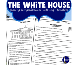
The White House Worksheets
Social Studies, History, History: USA, History: British, Grade 3, 4, 5, Worksheets, Worksheets & Printables
Where can you find the White House? What makes the Oval Office unique? Who was responsible for the White House fire in 1814? Your students will uncover answers to these inquiries and more as they delve into essential facts and details about the White House, commonly known as the People's House. This package includes: White House Reading Comprehension set White House Timeline activity Coloring activity featuring the White House Crafting a Letter to the White House Answer key Students will respond to questions using complete sentences, drawing on key details about the White House. They will utilize the provided reading material to construct a timeline showcasing significant historical events. Additionally, they'll have the chance to color an illustration of the White House and share three newfound insights. Finally, they'll draft a letter or create a drawing for potential submission to the White House. Instructions on how to send officially are included. Thank you! The White House Worksheets | The White House Worksheets | The White House Worksheets | The White House Worksheets | The White House Worksheets | The White House Worksheets | The White House Worksheets | The White House Worksheets | The White House Worksheets | The White House Worksheets | The White House Worksheets | The White House Worksheets |
Author Soumara Siddiqui
Tags The White House, White House Worksheets, White House Coloring Page, White House Facts
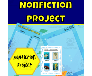
Nonfiction under the sea project
ELA, Writing, Creative Writing, Grade 1, 2, 3, 4, Projects, Activities
Put your students' concept knowledge and skills to the test with this excellent nonfiction research project. Students are required to follow a set of instructions to complete their research project. They will need to select a sea animal/creature to base their research on and come up with a catchy title page. There is a set of categories to pick from for chapter headings. Fill in the table of contents with chosen headings and page numbers, select a subheading for each heading allocated, and research and find factual information about the selected animal, including photographs/illustrations of information and a caption. At the end, students will be required to complete a glossary with difficult words they encountered and their definitions, fill in an index with keywords and page numbers those words can be found on, and finally, a bibliography with references they used to find out their information. Included in your purchase: Nonfiction research project: Online (Google slides) Nonfiction research project: Printable (PDF) Assessment rubric: Printable (PDF) DIRECTIONS: PDF Files can be printed and handed to students to complete. They can also be bound together to form a book. Google slides can be shared with students for them to complete online. A rubric can be completed a printed copies for each student. Use: You are free to use and modify the material. Non-commercial use only You may not resell the material. Nonfiction lessons: Nonfiction captions and labels Nonfiction Glossary Nonfiction table of contents Nonfiction title Nonfiction title page Nonfiction index
Author Ezee 101
Tags Nonfiction, Text Feature, Concept Development, Project, Under The Sea
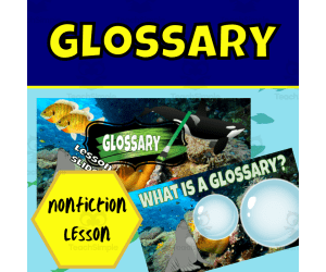
Nonfiction Text Features: Glossary Lesson
ELA, Reading, Grade 1, 2, 3, 4, Teacher Tools, Lesson Plans
This resource is a Nonfiction Text Feature: Glossary. A short and sweet lesson to introduce or recap the nonfiction text feature; glossary. This lesson aims to keep students engaged and interacting through class discussions and activities. Students will apply reading, creative thinking, problem-solving, and more as they work through these interactive slides. The objective of these lessons is to provide an introduction or recap of the nonfiction text feature; glossary. These lessons are aimed and creating a concrete understanding of the concepts through various activities as well as class discussions. Students will learn all about a glossary, and how to identify and apply them on their own. Class discussions and practice activities are included for students to apply their knowledge. There are lesson slides and student slides; the lesson slides can be presented to students as an introduction or recap lesson of the concepts. The lesson slides are animated as well as have speaker notes. Student slides can be given to students to complete during the lesson or as homework after the lesson. There are 2 different presentations - 1 for the lesson and 1 answer slide presentation. These slides are made through Google Slides an animations may work better through Google Slides . If you like this lesson be sure to have in our other Nonfiction lessons: Nonfiction lessons: Nonfiction captions and labels Nonfiction Glossary Nonfiction table of contents Nonfiction title Nonfiction title page Nonfiction index
Author Ezee 101
Tags Nonfiction, Glossary, Text Features, Concept Develpoment, Student Engagment, Interactive, Nonfiction Text Features Worksheet Answers, Nonfiction Text Features Powerpoint

Nonfiction Text Features: Index Lesson
ELA, Reading, Grade 1, 2, 3, 4, Teacher Tools, Lesson Plans
Introducing a Nonfiction Text Features: Index Lesson Engage your students with an interactive lesson that teaches them about indexes, an important nonfiction text feature. This resource aims to create concrete understanding through class discussions and hands-on practice. Over the course of the lesson, students will learn what an index is, why it is useful, and how to identify it within nonfiction texts. The slides incorporate discussions, think-pair-share opportunities, and activities that allow students to apply their new knowledge. Whether using this as an introduction or a review, the lesson is sure to reinforce this key concept. With customizable Google Slides, speaker notes, and ready-to-go student handouts, integrating this resource into your language arts or reading curriculum is seamless. Use it for whole-group teaching, small groups, or even independent practice. Suitable for grades 1-4. Expand your nonfiction text feature instruction with companion resources on captions, glossaries, tables of contents, titles, title pages, and more. Discover engaging interactive lessons that are teacher-created and classroom-tested.
Author Ezee 101
Tags Index, Vocabulary, Nonfiction, Text Features, Concept Development, Student Engagment, Interactive, Nonfiction Text Feature

Nonfiction Text Features: Heading and Subheading Lesson
ELA, Reading, Grade 1, 2, 3, 4, Teacher Tools, Lesson Plans
This resource is a Nonfiction Text Features: headings and subheadings Lesson. A short and sweet lesson to introduce or recap the nonfiction text features; headings and subheadings. This lesson aims to keep students engaged and interacting through class discussions and activities. Students will apply reading, creative thinking, problem-solving, and more as they work through these interactive slides. The objective of these lessons is to provide an introduction or recap of the nonfiction text features; headings and subheadings. These lessons are aimed and creating a concrete understanding of the concepts through various activities as well as class discussions. Students will learn all about headings and subheadings, how to identify them and how to apply them on their own. Class discussions and practice activities are included for students to apply their knowledge. There are lesson slides and student slides; the lesson slides can be presented to students as an introduction or recap lesson of the concepts. The lesson slides are animated as well as have speaker notes. Student slides can be given to students to complete during the lesson or as homework after the lesson. There are 2 different presentations - 1 for the lesson and 1 answer slide presentation. These slides are made through Google Slides an animations may work better through Google Slides . If you like this lesson be sure to have in our other Nonfiction lessons: Nonfiction lessons: Nonfiction captions and labels Nonfiction Glossary Nonfiction table of contents Nonfiction title Nonfiction title page Nonfiction index
Author Ezee 101
Tags Nonfiction, Text Features, Headings, Subheadings, Interactive Reading, Student Engagment, Interactive, Text Features Lesson Plan, Text Feature Lesson Plans

Nonfiction lesson
ELA, Reading, Grade 1, 2, 3, 4, Teacher Tools, Lesson Plans
Nonfiction Concepts Lesson Plan This interactive Google Slides resource teaches students the key concepts of nonfiction texts. Through discussions, activities, and practice, students will learn how to identify and apply nonfiction text features like captions, labels, glossaries, tables of contents, titles, title pages, and indexes. Animated slides, speaker notes, class discussion prompts, and student application activities allow this resource to be used flexibly: as an introductory whole-group lesson, a small group activity , or even home learning. This concrete, engaging resource aims to spark student creativity and critical thinking. Check out our shop for more nonfiction text features lessons covering glossaries, tables of contents, titles, title pages, and indexes. Made for grades 1-4.
Author Ezee 101
Tags Story Elements, Text Features, Nonfiction, Interactive Reading, Nonfiction Concept, Interactive, Student Engagement

Nonfiction Text Features: Photographs and Illusions Lesson
ELA, Reading, Grade 1, 2, 3, 4, Teacher Tools, Lesson Plans
This resource is a Nonfiction Text Features: photographs and illustrations Lesson. A short and sweet lesson to introduce or recap the nonfiction text features; photographs and illustrations. This lesson aims to keep students engaged and interacting through class discussions and activities. Students will apply reading, creative thinking, problem-solving, and more as they work through these interactive slides. The objective of these lessons is to provide an introduction or recap of the nonfiction text features; photographs and illustrations. These lessons are aimed and creating a concrete understanding of the concepts through various activities as well as class discussions. Students will learn all about captions and labels, and how to identify and apply them on their own. Class discussions and practice activities are included for students to apply their knowledge. There are lesson slides and student slides; the lesson slides can be presented to students as an introduction or recap lesson of the concepts. The lesson slides are animated as well as have speaker notes. Student slides can be given to students to complete during the lesson or as homework after the lesson. There are 2 different presentations - 1 for the lesson and 1 answer slide presentation. These slides are made through Google Slides an animations may work better through Google Slides . If you like this lesson be sure to have in our other Nonfiction lessons: Nonfiction lessons: Nonfiction captions and labels Nonfiction Glossary Nonfiction table of contents Nonfiction title Nonfiction title page Nonfiction index
Author Ezee 101
Tags Nonfiction, Text Features, Photographs, Illusions, Interactive Reading, Activities, Lesson Plans, Intractive, Student Engagment