2,790 products added recently
Page 635 - Newest Teaching Resources

Letter Y Reading Rings
ELA, Language Development, Phonics, Reading, Kindergarten, Preschool, Worksheets & Printables, Flashcards
These letter Y reading rings are great for students learning the beginning sound of the letter Y. These reading rings give students simple sentences to introduce them to reading in the format of "Y is for ____." What is Included: Letter Y Reading Ring cover card Letter Y reading ring cards The reading rings are available in color and in black and white These reading rings are suitable for preschool and kindergarten students who are learning the initial sound of the letter Y and are ready to begin reading simple sentences. The large, bold, and easy to recognize images will lead students towards success as they take the first steps to reading independently. When to Use: Literacy Centers - These cards work well in a literacy or reading center for students to read independently or with a partner. Small Group Activity - The teacher can pull aside a small group of students who need extra practice with the target sound to use these cards. Early Finisher Task - If students finish a task early, they can grab these cards to look at and read. Take Home Book - The black and white pages can be sent home for students to make their own letter sound book. This rings are easy to create. The teacher just needs to print each page, laminate each card (if desired) and then, using a hole punch, the teacher needs to place a hold in the indicated corner of the card. The cards are then placed on a ring for students to flip through each letter V card. Skills Assessed Letter Y Recognition Beginning Sounds Reading Simple Sentences These reading rings provide students with a fun and engaging way to practice reading simple sentences with words that begin with the letter Y. In this set, you can create a set for classroom use and the students can use the black and white set to make a set to take home and read with their families.
Author The Connett Connection
Tags Beginning Sounds, Alphabet Activities, Reading Center, Reading Activities, Emergent Readers, Beginning Readers, Preschool Readers, Flash Cards, Letter Y, Letter Y Activities
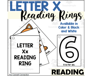
Letter X Reading Rings
ELA, Language Development, Phonics, Reading, Kindergarten, Preschool, Worksheets & Printables, Flashcards
These letter X reading rings are great for students learning the sound of the letter X. These reading rings give students simple sentences to introduce them to reading in the format of "X is for ____." What is Included: Letter X Reading Ring cover card Letter X reading ring cards The reading rings are available in color and in black and white These reading rings are suitable for preschool and kindergarten students who are learning the most common sound of the letter X and are ready to begin reading simple sentences. The large, bold, and easy to recognize images will lead students towards success as they take the first steps to reading independently. When to Use: Literacy Centers - These cards work well in a literacy or reading center for students to read independently or with a partner. Small Group Activity - The teacher can pull aside a small group of students who need extra practice with the target sound to use these cards. Early Finisher Task - If students finish a task early, they can grab these cards to look at and read. Take Home Book - The black and white pages can be sent home for students to make their own letter sound book. This rings are easy to create. The teacher just needs to print each page, laminate each card (if desired) and then, using a hole punch, the teacher needs to place a hold in the indicated corner of the card. The cards are then placed on a ring for students to flip through each letter X card. Skills Assessed Letter V Recognition Beginning Sounds Reading Simple Sentences These reading rings provide students with a fun and engaging way to practice reading simple sentences with words that have the letter X. In this set, you can create a set for classroom use and the students can use the black and white set to make a set to take home and read with their families.
Author The Connett Connection
Tags Beginning Sounds, Alphabet Activities, Reading Center, Reading Activities, Emergent Readers, Beginning Readers, Preschool Readers, Flash Cards, Letter X, Letter X Activities

Letter W Reading Rings
ELA, Language Development, Phonics, Reading, Kindergarten, Preschool, Worksheets & Printables, Flashcards
These letter W reading rings are great for students learning the beginning sound of the letter W. These reading rings give students simple sentences to introduce them to reading in the format of "W is for ____." What is Included: Letter W Reading Ring cover card Letter W reading ring cards The reading rings are available in color and in black and white These reading rings are suitable for preschool and kindergarten students who are learning the initial sound of the letter W and are ready to begin reading simple sentences. The large, bold, and easy to recognize images will lead students towards success as they take the first steps to reading independently. When to Use: Literacy Centers - These cards work well in a literacy or reading center for students to read independently or with a partner. Small Group Activity - The teacher can pull aside a small group of students who need extra practice with the target sound to use these cards. Early Finisher Task - If students finish a task early, they can grab these cards to look at and read. Take Home Book - The black and white pages can be sent home for students to make their own letter sound book. This rings are easy to create. The teacher just needs to print each page, laminate each card (if desired) and then, using a hole punch, the teacher needs to place a hold in the indicated corner of the card. The cards are then placed on a ring for students to flip through each letter W card. Skills Assessed Letter V Recognition Beginning Sounds Reading Simple Sentences These reading rings provide students with a fun and engaging way to practice reading simple sentences with words that begin with the letter W. In this set, you can create a set for classroom use and the students can use the black and white set to make a set to take home and read with their families.
Author The Connett Connection
Tags Beginning Sounds, Alphabet Activities, Reading Center, Reading Activities, Emergent Readers, Beginning Readers, Preschool Readers, Flash Cards, Letter W, Letter W Activities

Letter V Reading Rings
ELA, Language Development, Phonics, Reading, Kindergarten, Preschool, Worksheets & Printables, Flashcards
These letter V reading rings are great for students learning the beginning sound of the letter V. These reading rings give students simple sentences to introduce them to reading in the format of "V is for ____." What is Included: Letter V Reading Ring cover card Letter V reading ring cards The reading rings are available in color and in black and white These reading rings are suitable for preschool and kindergarten students who are learning the initial sound of the letter V and are ready to begin reading simple sentences. The large, bold, and easy to recognize images will lead students towards success as they take the first steps to reading independently. When to Use: Literacy Centers - These cards work well in a literacy or reading center for students to read independently or with a partner. Small Group Activity - The teacher can pull aside a small group of students who need extra practice with the target sound to use these cards. Early Finisher Task - If students finish a task early, they can grab these cards to look at and read. Take Home Book - The black and white pages can be sent home for students to make their own letter sound book. This rings are easy to create. The teacher just needs to print each page, laminate each card (if desired) and then, using a hole punch, the teacher needs to place a hold in the indicated corner of the card. The cards are then placed on a ring for students to flip through each letter V card. Skills Assessed Letter V Recognition Beginning Sounds Reading Simple Sentences These reading rings provide students with a fun and engaging way to practice reading simple sentences with words that begin with the letter V. In this set, you can create a set for classroom use and the students can use the black and white set to make a set to take home and read with their families.
Author The Connett Connection
Tags Beginning Sounds, Alphabet Activities, Reading Center, Reading Activities, Emergent Readers, Beginning Readers, Preschool Readers, Flash Cards, Letter V, Letter V Activities

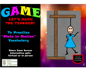
Free Science Plates in Motion Interactive Vocabulary Review Activity
Science, Basic Science, Earth and Environmental Sciences, Earth Sciences, Environmental Science, Grade 7, Teacher Tools, Lesson Plans
Science 7th Grade Plates in Motion Vocabulary Review Reinforce plate tectonics concepts with this interactive 7th grade science vocabulary review! Students will learn key terms about plates in motion through definitions and characteristics. The engaging activity promotes collaboration and class discussion as students review terms like convergent boundary, transform boundary, and more. With multiple visuals and learning formats like multiple choice questions, this versatile resource can be used for whole group instruction, small group practice, or independent work. Check our shop for more 7th grade interactive science vocabulary reviews covering topics like human microbiome, metabolism, and more grade levels in science and Spanish language arts. This 1-page PowerPoint includes 41 slides.
Author ShapeUp-N-Matematicas y Lenguaje
Tags Plates In Motion, Earthquake, Eruption, Volcanic Activity, Geiser, Landform, Trench, Small Or Whole Group, Interactive Activity, Games

Free Science Chemical Reaction Interactive Vocabulary Review Activity
Science, Basic Science, Life Sciences, Biology, Chemistry, Grade 7, Activities, Experiments, Teacher Tools, Lesson Plans
Free Science Chemical Reaction Vocabulary Review for Grade 7 This interactive PowerPoint teaches and reviews key vocabulary words related to chemical reactions in grade 7 science. It covers concepts like characteristics and the importance of chemical reactions. The presentation features a multiple choice review activity to assess understanding. Students select a letter and the answer is revealed. If incorrect, the answer is marked with an X until the right selection is made. The activity is visual, interactive, and engaging for whole group or independent practice. It's perfect for remote learning. After reviewing the 29 slides, students will have learned and reinforced seventh grade science vocabulary on chemical reactions. The activity is part of a series from ShapeUp-N-Matematicas y Lenguaje focused on middle grades science and Spanish language arts.
Author ShapeUp-N-Matematicas y Lenguaje
Tags Chemical Reaction, Periodic Table, Chemical Structure, Boiling Point, Freezing Point, Endothermic Reaction, Exothermic Reaction, Small Or Whole Group, Interactive Activity, Games
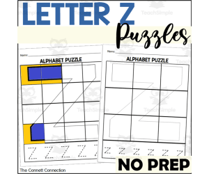
Letter Z Puzzles
ELA, Writing, Handwriting, Kindergarten, Preschool, Worksheets & Printables, Worksheets
Letter Z Puzzles These printable puzzles help preschool and kindergarten students practice letter recognition, letter formation, and fine motor skills. Students color letter Z pictures, cut them into 9 or 12 puzzle pieces, then glue the pieces onto letter mats to complete the puzzles. Both uppercase and lowercase letter Z puzzles are included to allow for differentiation. After assembling each puzzle, students trace the matching letter. With no prep required beyond providing art supplies, these engaging worksheets are ideal for independent practice, small groups, learning centers , sub plans, and more. As an alternative implementation, teachers can laminate colored puzzles for reuse with file folders to create durable letter Z matching games.
Author The Connett Connection
Tags Alphabet Puzzles, Letter Puzzles, Handwriting Practice, Letter Recognition, Letter Of The Week, Alphabet Worksheets, Identifying Letters, Letter Z, Letter Z Activities, Letter Z Worksheets

Letter Y Puzzles
ELA, Writing, Handwriting, Kindergarten, Preschool, Worksheets & Printables, Worksheets
Letter Y Puzzles Students will build letter recognition, fine motor skills, and handwriting formation with these letter Y puzzle pages. The packet includes 4 puzzles with pieces ranging from 9 to 12 pieces. Students color and cut puzzle pieces, then rebuild the letter Y. Finally, they practice tracing both capital and lowercase letter Y. These no-prep worksheets allow independent practice across multiple centers like arts and crafts , puzzles, alphabet, and small group. The pieces can also be laminated for reusable letter building puzzles. Letter Y Puzzles provides engaging letter recognition for preschool and kindergarten.
Author The Connett Connection
Tags Alphabet Puzzles, Letter Puzzles, Handwriting Practice, Letter Recognition, Letter Of The Week, Alphabet Worksheets, Identifying Letters, Letter Y, Letter Y Worksheets, Letter Y Activities
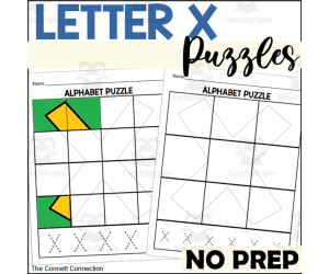
Letter X Puzzles
ELA, Writing, Handwriting, Kindergarten, Preschool, Worksheets & Printables, Worksheets
Letter X Puzzles These printable letter X puzzles allow preschool and kindergarten students to practice letter recognition, letter formation, and fine motor skills. Students color, then cut out puzzle pieces to build a letter X puzzle. Capital and lowercase letter puzzles in 9 or 12 pieces provide differentiated practice. After assembling their letter puzzle, students trace the matching capital or lowercase X. Letter puzzles develop skills like letter recognition, handwriting practice, fine motor skills, matching images, and cutting. Teachers can provide these no-prep letter X puzzles for independent practice or small groups. Alternatively, laminate colored puzzle pieces for reusable alphabet puzzles. File folder games extend learning. Use letter puzzles during reading centers, arts and crafts , morning work, sub plans, or for assessment.
Author The Connett Connection
Tags Alphabet Puzzles, Letter Puzzles, Handwriting Practice, Letter Recognition, Letter Of The Week, Alphabet Worksheets, Identifying Letters, Letter X, Letter X Activities, Letter X Worksheets
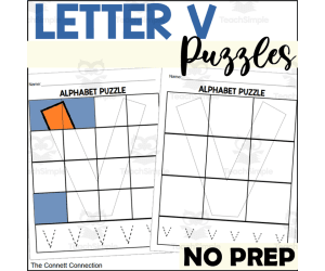
Letter V Puzzles
ELA, Writing, Handwriting, Kindergarten, Preschool, Worksheets & Printables, Worksheets
Letter V Puzzles Students will have fun practicing letter recognition, matching, and fine motor skills with these engaging Letter V puzzles. The packet includes both 9 and 12-piece capital and lowercase letter V puzzles. Children will first color the puzzle template page. Next, they'll carefully cut out the pieces. Finally, they'll glue the pieces onto the puzzle mat to complete the letter V. The pages also provide an opportunity for students to trace the letter V to practice proper letter formation. Teachers can implement these multifaceted Letter V puzzles in various learning centers, small groups, or as independent practice. The no-prep activities allow assessment of skills like letter recognition, fine motor skills, matching images, cutting, and handwriting. Alternatively, teachers can laminate a colored puzzle template for students to complete repeatedly when building the letter with free-standing pieces.
Author The Connett Connection
Tags Alphabet Puzzles, Letter Puzzles, Handwriting Practice, Letter Recognition, Letter Of The Week, Alphabet Worksheets, Identifying Letters, Letter V, Letter V Activities, Letter V Worksheets
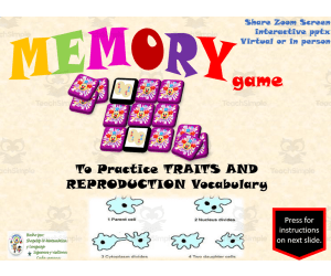
Free Science Interactive Memory Game / Traits and Reproduction Voc.
Science, Life Sciences, Human Body, Basic Science, Biology, Grade 8, Games, Activities
Traits and Reproduction Interactive Science Memory Game for 8th Grade Reinforce 8th grade science lessons on traits and reproduction with this interactive memory game . Students will learn, practice, and review key vocabulary words and definitions related to characteristics, importance, and the relationships between them. The game features visual aids and multiple learning activities to aid memorization, recognition, identification, and classification of the content. Students will first practice the vocabulary, then play the memory game on PowerPoint, matching pairs of cards to test their knowledge. This engaging resource can be used for whole group, small group, or individual practice in the classroom or at home. This teaching resource includes a 19-slide PowerPoint presentation with a built-in interactive memory game to help 8th graders master science concepts related to traits and reproduction.
Author ShapeUp-N-Matematicas y Lenguaje
Tags Traits And Reproduction, Traits, Reproduction, Dna, Feature, Fertilization, Ribosomes, Chromosomes, Small Or Whole Group, Interactive Activity
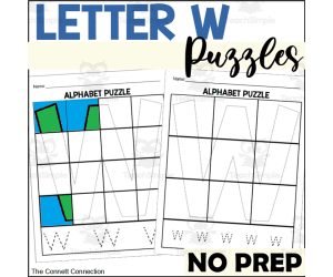
Letter W Puzzles
ELA, Writing, Handwriting, Kindergarten, Preschool, Worksheets & Printables, Worksheets
These letter W puzzle craft worksheets allow students to practice letter recognition and letter formation all on one page. These alphabet puzzle pages are differentiated by having both 9 piece puzzles and 12 piece puzzles for students to complete. These letter W puzzles are suitable to preschool and kindergarten students who are working on letter recognition and practicing their handwriting skills. Students will color the letter W puzzle picture any way they choose, cut it out, then glue it onto their letter W puzzle mat to complete their letter W puzzle. Students will then trace the letter W at the bottom of the page. There are both capital and lowercase letter puzzles. What is Included: There is 1 capital letter puzzle with 12 pieces There is 1 lowercase letter puzzle with 12 pieces There is 1 capital letter puzzle with 9 pieces There is 1 lowercase letter puzzle with 9 pieces There are puzzle template pages for students to color, cut out, and glue to the puzzle pages. When to Use Arts and Crafts Center Puzzle Center Alphabet Center Small Group Activity Independent Activity Morning Work Emergency Sub Plans Skills Assessed Letter Recognition Fine Motor Skills Handwriting Practice and Letter Formation Matching images to build a letter Cutting Skills These puzzle pages are a no prep activity for teachers to give students to complete. The teacher simply needs to provide markers or crayons as well as scissors and glue for students to complete the puzzle and tracing tasks. An alternative to completing this activity as a worksheet is to allow students to color their puzzle template page however they wish, then laminate and cut out the pieces to create a free standing puzzle the student can complete over and over for repeated practice with building the letter. It can also be placed in a file folder to make a game.
Author The Connett Connection
Tags Alphabet Puzzles, Letter Puzzles, Handwriting Practice, Letter Recognition, Letter Of The Week, Alphabet Worksheets, Identifying Letters, Letter W, Letter W Activities, Letter W Worksheets

DRAW THE HALF - Developing Attention and Concentration
Creative Arts, Art, Preschool, Grade 1, 2, Drawing Templates & Outlines, Worksheets & Printables
1. Introduction As is known by educational agents, making drawings of symmetrical figures offers various advantages and/or benefits for the cognitive, motor and creative development of students. For this reason, today I present to you this fantastic worksheet. 2.Objective The purposes of this educational sheet are: - Develop fine motor coordination: Drawing symmetrical figures involves drawing lines and shapes with precision. This process helps improve children's fine motor coordination, since they must learn to precisely control the movement of their hands and fingers to then achieve symmetry in the drawing. - Promote visual perception: When we draw symmetrical figures, students are required to observe carefully and understand what symmetry is like in relation to a central axis. This will help and contribute to the development of visual perception, understanding of patterns, shapes in the environment as well as the ability to recognize patterns. - Stimulate logical thinking: As is known, symmetry implies a sense of balance and order. When we draw symmetrical figures, children will be applying logical principles to ensure that both sides of the figure or object are equal. This will help foster logical thinking and reasoning skills. - Promote creativity and aesthetics: Although you may be thinking that symmetry follows patterns and rules, believe it or not, it still leaves spaces for the student to develop their creativity. You should know that, thanks to this fantastic activity, children will be able to play with designs, colors and details on both sides of the figure or object, which will help promote artistic expression and the development of the aesthetic sense. - Understand basic mathematical concepts: You should know that symmetry is also related to basic mathematical concepts such as equality of lengths, equality of angles on opposite sides of the figure as well as the well-known axis of symmetry. By drawing symmetrical figures, you will introduce your children or students to all these concepts in a practical and visual way. 3.Order, scheme and stages Introduce your class creatively through a motivating dynamic that awakens children's interest. Then just enter the worksheet. 4.Grades or ages This worksheet can be developed by children from 4 to 9 years old. 5. Form of application Print this sheet and apply it individually. 6. Answer keys This game does not require answers. 7.Use text labels drawing, draw , draw for kids, art, activity art. 8.Rules Specified above. 9.File types The archive is in PDF format. 10.Number of pages This document contains 9 pages.
Author EDITORIAL LAURA EDUCA
Tags Art, Art Activity, Draw, Drawing, Draws For Kids
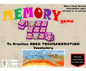
Free Science Interactive Memory Game / Rock Transformation Vocabulary
Science, Earth and Environmental Sciences, Basic Science, Earth Sciences, Environmental Science, Grade 7, Games, Activities
Free Science Interactive Memory Game / Rock Transformation Vocabulary Reinforce seventh-grade science curriculum covering rock transformations with this interactive memory game. Students will learn, practice, and review key vocabulary words and definitions related to rock transformations in an engaging game format. The 17-slide PowerPoint includes visual aids to boost retention and multiple built-in reviews. Use this versatile resource for whole class instruction, small groups, individual practice, or even homework. As students match coordinating image and definition pairs, this activity strengthens memory, concentration, visual recognition, and information processing skills. For more interactive science games and resources, search our store for Spanish math, language arts, reading, and writing materials spanning kindergarten through fifth grade.
Author ShapeUp-N-Matematicas y Lenguaje
Tags Rock Transformation, Igneous Rock, Magma, Plate, Sedimentary Rock, Small Or Whole Group , Interactive Activity, Game, Sediment, Plate Boundary

Free Science Interactive Memory Game / Plates in Motion Vocabulary
Science, Earth and Environmental Sciences, Basic Science, Environmental Science, Grade 7, Games, Activities
Plates in Motion Vocabulary Science Memory Game for 7th Grade Engage your 7th grade science students with this interactive memory game that helps them learn, practice, and review key vocabulary and concepts related to plate tectonics. With visual aids and multiple built-in reviews, this PowerPoint game strengthens understanding of terminology and relationships between plates, boundaries, motion, and more. Students will match coordinating image and text cards, using concentration and recall. Flip non-matches face down again to keep guessing until all 20 cards compile into 10 pairs. Replay as desired. Use game whole-group on classroom display, partners at stations, or individual review. Supports differentiation and formative assessment . From teacher-created store with diverse engaging activities for Spanish language learning.
Author ShapeUp-N-Matematicas y Lenguaje
Tags Plates In Motion, Earthquake, Geyser, Landformation, Eruption, Volcano, Volcanic Activity, Trench, Small Or Whole Group, Interactive Activity
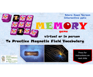
Free Science Interactive Memory Game / Magnetic Field Vocabulary
Science, Basic Science, Earth and Environmental Sciences, Earth Sciences, Environmental Science, Grade 8, Games, Activities
Magnetic Field Vocabulary Memory Game (Grade 8) Reinforce key science concepts related to magnetic fields with this interactive 8th grade vocabulary review game . Students will learn and practice 10 essential magnetic field terms by matching pairs of words and definitions. Engaging visuals, reviews, and a digital "memory game " format promote memorization, recognition, identification, and classification of key information. Use this flexible learning tool for whole group instruction, small group practice, or at-home review. Includes a ready-to-go editable 10 slide PowerPoint presentation to play in class or assign digitally. Aligned to grade 8 science curriculum.
Author ShapeUp-N-Matematicas y Lenguaje
Tags Magnetic Field, Compass, Transfer, Energy, Potential Energy, Kinetic Energy, Poles, Small Or Whole Group, Interactive Activity, Games

Free Science Interactive Memory Game / Light Waves Vocabulary
Science, Basic Science, Earth and Environmental Sciences, Earth Sciences, Physics, Grade 8, Games, Activities
Light Waves Vocabulary Memory Game for 8th Grade Science Practice key light waves vocabulary with this interactive 8th grade science memory game. By matching terms like wavelength, amplitude, and more to their definitions, students will improve their scientific vocabulary and memory in an engaging way. This educational game aligns to 8th grade physical science curriculum about light waves. Use it for whole group practice, small groups, or even as a homework assignment. The 18-slide PowerPoint includes colorful images along with light waves terminology. Play it digitally or print it out for a hands-on classroom activity . As students match the vocabulary words to their definitions, their memorization, visual memory, concentration and more is strengthened. Extend the learning by using other 8th grade science resources in our store like interactive readings, vocabulary reviews, assessment activities and more.
Author ShapeUp-N-Matematicas y Lenguaje
Tags Light Waves, Ultraviolet, Electric Waves, Light, Frequency, Small Or Whole Group, Interactive Activity, Games, Memory Game, Science Vocabulary

Free Science Interactive Memory Game / Chemical Reaction Vocabulary
Science, Chemistry, Earth and Environmental Sciences, Earth Sciences, Grade 7, Games, Activities
Chemical Reactions Memory Game for Science Class This grade 7 science resource covers chemical reactions vocabulary through an interactive PowerPoint memory card game. Students will learn, practice, and review 13 key terms related to 7th grade chemistry experiments . The game builds visual memory, concentration, brain activity, and cognitive skills. Use it for individual practice or whole class. Instructions guide students to match pairs of cards. Correct matches stay face up, while incorrect guesses flip back over. Play repeats until all cards are matched. Other middle school science vocabulary games in our store cover topics like geometry shapes, geography, plants, animals, and more to reinforce lessons. This specific chemical reactions matching game includes visuals and definitions for concepts like reactants, products, catalysts, synthesis, decomposition, and single & double replacement.
Author ShapeUp-N-Matematicas y Lenguaje
Tags Chemical Reaction, Periodic Table, Freezing Point, Boiling Point, Endothermic Reaction, Exothermic Reaction, Small Or Whole Grou[, Interactive Activity, Games, Chemistry
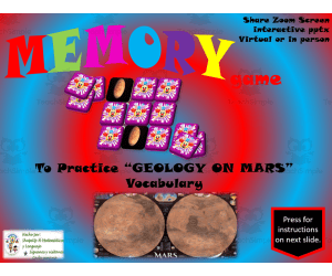
Free Science Interactive Memory Game / Geology on Mars Vocabulary
Science, Earth and Environmental Sciences, Space, Earth Sciences, Environmental Science, Grade 8, Games, Activities
Mars Geology Vocabulary Memory Game for 8th Grade Science Practice, review, and reinforce Mars geology terms for 8th grade science students with this interactive memory game . Students will match geology vocabulary words like caldera, rille, and volcano with their definitions. The game strengthens visual memory, concentration, brain activity, and cognitive abilities. Use it for whole group practice on a projector or have students play individually on devices. The 19-slide PowerPoint includes the terminology list and an interactive matching game that prompts students to locate coordinate points to reveal the vocabulary cards. See more 8th grade science games focused on astronomy, earth science, and environmental concepts in our ShapeUp-N-Matematicas y Lenguaje store.
Author ShapeUp-N-Matematicas y Lenguaje
Tags Geology On Mars, Geology, Geosphere, Habitat, System, Scientific Argument, Small Or Whole Group, Interactive Activity, Games, Weathering

Free Science Interactive Hangman Game / Rock Transformation Vocabulary
Science, Earth and Environmental Sciences, Basic Science, Earth Sciences, Grade 7, Games, Activities
Rock Transformation Vocabulary Hangman Game Learn and review key 7th grade science vocabulary words related to rock transformations with this interactive hangman game. Students will build their knowledge of important terms and definitions while having fun playing the classic hangman game. This 22-slide PowerPoint can be used for individual, small group, or whole class review. First, students study the vocabulary words and meanings. Next, they take turns guessing letters to solve hangman puzzles for each word. If they guess incorrectly, part of the hangman is drawn. The goal is to solve the word before the full hangman is complete. This activity stimulates intelligence, builds concentration, reinforces letter recognition, improves spelling and pronunciation, and expands science vocabulary in an engaging way. It's a perfect supplement for any lesson on the rock cycle or rock transformations. Other Spanish language games and activities available in our TpT store.
Author ShapeUp-N-Matematicas y Lenguaje
Tags Rock Transformation, Rocks, Minerals, Plate, Plate Boundary, Igneous Rock, Magma, Sediment, Sedimentary Rock, Small Or Whole Group

Vocabulary with Cards | Crossword Wordsearch Anagram PARTY
Special Resources, ELA, Creative Arts, Art, Special Education Needs (SEN), Speech Therapy, Life Skills, Language Development, ESL, Writing, Handwriting, Spelling, Vocabulary, Music, Not Grade Specific, Crosswords Puzzles, Worksheets, Worksheets & Printables
Word Games with Puzzles | Crossword Wordsearch Anagram | PARTY . A resource designed especially for educators who value enhancing language skills in inventive ways . This pack provides a diverse set of word games and puzzles, all centered on the theme of PARTY . Created to engage students meaningfully and rectify their knowledge about commonly used PARTY-related words . Educators are provided with several varied activities: anagrams, copy words crossword, a blank writing board, lined writing board, word matching page, wheel chart and word search board . The chosen vocabulary words cater to useful PARTY-related phrases, thus creating context-based learning . Versatility of the Resource . This versatile resource can be used in multiple ways . Kickstart the day with these activities as part of morning work routine or incorporate into teaching centers for active learning participation . Also use them as handouts or even as fun homework assignments which students would love to participate in! Beyond Classroom Applications . The application isn't just confined to the classroom alone; they are adaptable enough for therapy sessions too! Whether you are working on language development exercises like vocabulary enhancement or conversation prompts in group settings - these worksheets provide varied options that serve different purposes . You Receive : An easy-to-use package - an 24 pages pdf file combining worksheets and images ready for immediate use after printing! A non-grade specific resource- adaptable enough to be used by different grade levels conveniently! Note : These games not only concentrate on mastering language arts but also aid learners in understanding scientific and community concepts while assisting develop cognitive skills simultaneously! Conclusion : Enrich your teaching environment with this multi-faceted tool that aims not just at direct instruction but skill-building across various domains – a crucial aspect towards accomplishing holistic education! Included: 24 page PDF with word games worksheets and flash cards .
Author WORDS ASIDE
Tags Flash Cards, Esl, Thematic Vocabulary, Word Wall, Independent Work, Centers, Writing Expository, Community, Words Aside, Social Life

Free Science Interactive Hangman / Traits and Reproduction Vocabulary
Science, Life Sciences, Human Body, Biology, Grade 8, Teacher Tools, Lesson Plans
Interactive Science Vocabulary Hangman for 8th Grade Reproduction and Traits Engage your 8th grade science students with this interactive hangman game to help them learn and review key vocabulary words and definitions related to traits, reproduction, and characteristics. This 24-slide PowerPoint game allows students to practice 24 important 8th grade science terms first before playing a lively round of hangman. To play, students guess letters and if correct, the letters fall into place. Incorrect guesses lead to drawing another body part of the hangman. With multiple visuals and built-in reviews, this activity stimulates intelligence, builds concentration and retention, and increases science vocabulary and pronunciation skills. Use it for whole-group practice, individual review, or even homework for a fun way to reinforce 8th grade science curriculum on traits and reproduction. More Spanish games and activities for math, language arts, and more levels available in our TpT store.
Author ShapeUp-N-Matematicas y Lenguaje
Tags Reproduction, Traits, Traits And Reproduction, Chromosomes, Fertilization, Ribosomes, Dna, Human Feature, Interactive Activity, Small Or Whole Group

Question Words Poster, Interrogative Sentences
ELA, Grade 3, 4, 5, 6, 7, 8, Posters, Classroom Decor
Two English grammar posters elucidate question words: who, where, when, why, what, which, how and whose , for quick reference. Elevate your students' communication skills through the Question Words Poster . Crafted for educators and homeschooling guardians, this chart aids children in grasping the vital role of question words for robust language development. Dive deeper into the Question Words Poster , designed as an indispensable aid for educators and homeschooling guardians to fortify language proficiency in children. Unlocking Communication Mastery: This meticulously crafted poster unveils the magic of question words—Who, Where, When, Why, What, Which, How, and Whose—in a visually engaging and accessible format. Each question word acts as a key to unlock a realm of understanding, allowing young learners to navigate language with confidence and precision. Empowering Learners: The vibrant and intuitive design of this poster captivates young minds, turning the often complex realm of grammar into an exciting exploration. Through clear explanations and vivid examples, students embark on a journey to comprehend the fundamental roles these question words play in communication. Building Strong Foundations: In the hands of educators and homeschooling guardians, this chart becomes a cornerstone for cultivating robust language skills. It serves as a catalyst for interactive learning sessions, sparking discussions that encourage critical thinking and linguistic prowess. From unraveling the mysteries of 'Why did it happen?' to pinpointing 'Where does it occur?' or 'How is it done?', this poster paves the way for comprehensive comprehension of language nuances. Facilitating Versatile Learning: Adaptable to various learning environments, this poster seamlessly integrates into classrooms, study corners, or homeschooling setups. Its presence is an invitation for exploration, prompting students to delve deeper into the world of language acquisition. In essence, the Question Words Poster stands as a beacon, illuminating the path toward articulate and expressive communication. Its purposeful design and rich content empower both educators and learners alike, fostering an environment where language thrives and curiosity flourishes. What question words are included? Who Where When Why What Which How Whose How many (countable) How much (uncountable) How long How often How far How old How about
Author educ_project
Tags English Grammar Posters, Grammar Posters
Free Science Interactive Hangman Game / Plates in Motion Vocabulary
Science, Earth and Environmental Sciences, Basic Science, Earth Sciences, Grade 7, Games, Activities
Plates in Motion Vocabulary Hangman Game Engage 7th grade students with this interactive science vocabulary game to learn about plate tectonics. Students will practice 27 key terms and definitions related to plates in motion through an engaging hangman game format. As a whole class or small group activity, students suggest letters to guess the hidden vocabulary word. Correct letters appear in place, while incorrect guesses slowly reveal the hangman. This multifaceted resource builds critical thinking, reinforces content knowledge, and expands science vocabulary in a fresh, collaborative way. Appropriate for in-person or virtual 7th grade science lessons, this game includes a 27-slide PowerPoint presentation to guide interactive learning.
Author ShapeUp-N-Matematicas y Lenguaje
Tags Plates In Motion, Earthquake, Eruption , Volcano, Landformation, Geyser, Trench, Games, Interactive Activity, Small Or Whole Group