2,759 products added recently
Page 975 - Newest Teaching Resources

Body Behavior Reminder Cards | Classroom Management | Manners
Resources for Teachers, Classroom Management, Kindergarten, Preschool, Grade 1, 2,
The Body Behavior Reminder Cards are a unique, valuable educational aid that assists in managing classroom behavior while promoting manners and self-awareness. This tool is great for settings like public schools or home education platforms. Flexibility of Use Crafted with thoughtful design, these cards offer educators easy visual reminders of appropriate classroom behavior. Depending on your preference, they can be printed large for communal emphasis or small enough to place at individual desks for personal reference. Catering to Special Needs Learners These Body Behavior Reminder Cards are designed specially keeping special needs learners in mind. The resource includes three sets of six posters each, demonstrating how different parts of the body - eyes, ears, hands, feet and mouth should be utilized appropriately within the class setting across varying reading levels. Detailed Descriptions One-word Interpretations Title-only versions Beyond Age Limitations & Classrooms The utility is not just limited to a certain age group or confined within classrooms - it's as effective from preschoolers up through second graders across mixed subjects too! Furthermore talks about dos and don'ts initiated by these cards could also inspire noticeable changes at home! Packaged Power-Tool for Peaceful Learning Spaces & Manners Education A convenient 18-page PDF format packs this all into one easy-to-navigate resource without compromising any content. Implementing visually driven methods such as this can simplify conflict management within learning environments significantly more than words alone! "With the Body Behavior Reminder Cards as part of your toolkit - watch behaviors change one card flip at a time!" </em
Author Simply Schoolgirl
Tags Classroom Management, Behavior Reminders, Educational Tool, Visual Cues, Special Needs Learners, Behavior Cards For Students

Presentation Skills: Ocean Counting - Level 1 Difficulty
Math, Numbers, Creative Arts, Art, Preschool, Grade 1, Presentations, Teacher Tools
Presentation Skills: Ocean Counting - Level 1 Difficulty A key educational tool for beginners learning to navigate presentation software, incorporating elements of Math and Art & Music in a simplified interface. Features An engaging counting activity with ocean creatures. Differentiated versions for varied student engagement. Flexible usage between group lessons or individual work. Included Materials The product contains the following:Brief instructions, lesson plan guide, notes for teachers . The files come in .PPTX format with attached conversion instructions for Google Slides if needed. Requirements: This product necessitates technology access like 1:1 computer or tablet screens unless adapted into a group activity display setting. Courtesy Note: Please respect copyrights by using this single-use teaching resource responsibly. Direct other interested educators to download it from its original listing rather than sharing copies freely around.
Author Lab LLama - Computer Skills Resources
Tags Presentation Skills, Educational Tool, Counting Activity, Math, Art & Music

Choosing Reliable Sources Lesson
ELA, Strategies, Writing, Research, Grade 9, 10, 11, 12, Teacher Tools, Lesson Plans
If your students are diving deep into writing projects , you have more than likely introduced the topic of choosing sources. Whether students are writing argumentative essays or opinion writing, you probably have students sources evidence to support their writing. We know that our writing may only be as strong as the sources we pull our information from. Teaching students how to find strong sources is an important skill. This is a Choosing Reliable Sources Lesson to help students determine which sources can be trusted and which ones cannot. The objective is for students to recognize credible and reliable sources by using the CRAAP test. The CRAAP acronym is as follows: C – currency R – relevance A – authority A – accuracy P – purpose Students will learn about peer reviewed journals and the 6 indicators of a reputable journal. There will be a number of helpful tips to support students when researching. I hope you enjoy! Here are links to similar resources in my store: https://teachsimple.com/product/abstract-form-lesson-activity https://teachsimple.com/product/addition-matching-velcro-activity https://teachsimple.com/product/art-history-research-project https://teachsimple.com/product/addition-file-folder Be sure to check out my storefront here: https://teachsimple.com/contributor/resource-garden I can be contacted for questions and concerns at nicole.maizelis@gmail.com .
Author Resource Garden
Tags Writing Lesson, Choosing Reliable Sources, Peer Reviewed Journals, Research Strategies, Citing Text Evidence, Literacy, Small Group, Reading Project

Book Club, but with a twist!
ELA, Reading, Grade 7, 8, 9, 10, Activities
Whether you are a science teacher, a social studies teacher, or even a math teacher, one thing is for certain. We are all reading teachers! Within every subject, texts are involved. Our students are always tasked with reading. Even in math, students are reading instructions, word problems and so forth. If you’ve never thought about starting a book club in your classroom, here’s your sign! This is a Book Club, but with a twist! Within this presentation, you’ll have everything you need to effortlessly implement a book club with your students. Here is an introduction for students: What you need to know: You and your group will have to decide how you will split the novel up into 6 sections You will need to decide which role each of your will begin with Each week, your role will change, so by the end of the book, you will have had a chance to try each role You will be submitting the work you complete for each role Your peers will be assessing your participation each meeting I will be popping into your meetings to listen in for funzies You will meet with your group once a week, every Friday There are 7 different groups in the presentation. There are 4 different roles included: 1. Host or Leader 2. Cruciverbalist 3. Conspiracy Theorist 4. Section Critic Each role will be described in detail. A planner is included to properly assign student roles based on weeks and chapters. This is an editable presentation designed for middle school and high school students. I hope you enjoy! Here are links to similar resources in my store: https://teachsimple.com/product/abstract-form-lesson-activity https://teachsimple.com/product/addition-matching-velcro-activity https://teachsimple.com/product/art-history-research-project https://teachsimple.com/product/addition-file-folder Be sure to check out my storefront here: https://teachsimple.com/contributor/resource-garden I can be contacted for questions and concerns at nicole.maizelis@gmail.com .
Author Resource Garden
Tags Book Club, Group Roles, Vocabulary Review, Small Groups, Forming Questions, Student Leaders, Comprehension Strategies, Graphic Organizers
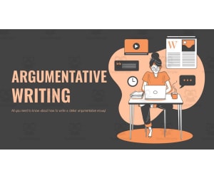
Argumentative Writing Lesson
ELA, Writing, Grade 8, 9, 10, 11, Teacher Tools, Lesson Plans
Writing is a skill that students often need thorough supports with. Any time we can implement a detailed writing lesson, we are able to see how beneficial it is to our students. This is an Argumentative Writing Lesson that allows student to learn new knowledge, practice their writing skills and show what they know. The objective is for students to write a 5-paragraph argumentative essay with the use of counterclaims to support their argument. This resource was designed for middle and high school students. This presentation will begin by: --Teaching students about the 4 elements that a good argumentative essay needs. --Students will learn about the two ways to place counterclaims in a 5-paragrph essay. --Following a flowchart for deconstructing essays. Two argumentative essays are included in the presentation that will allow students to analyze the components they have learned about thus far. Students task is as follows: “Health Canada is considering banning all food advertisements that are targeted to children and youth up to age 17, that promote unhealthy or non-nutritious foods. You are asked to identify whether you agree that unhealthy, or non-nutritious, food advertisements should be banned from all places that interact with children and youth up to age 17. This would mean on television channels that are usually seen by children and youth, websites that are visited by children and youth, and magazines that are targeted towards children and youth.” The following slides will allow students space to organize their thoughts from beginning to end. A success criterion is included. I hope you enjoy! Here are links to similar resources in my store: https://teachsimple.com/product/agamograph-self-reflection-form https://teachsimple.com/product/social-story-for-safe-hands-and-feet https://teachsimple.com/product/art-history-research-project https://teachsimple.com/product/addition-file-folder Be sure to check out my storefront here: https://teachsimple.com/contributor/resource-garden I can be contacted for questions and concerns at nicole.maizelis@gmail.com .
Author Resource Garden
Tags Writing Lesson, Argumentative Essay, Argumentative Writing, Counterclaims, Paragraph Writing, Middle School, Writing Project, Writing Supports

Understanding Integers: Graphing Integers on a Number Line
Math, Number Lines, Early Math, Algebra, Grade 5, 6, 7, Worksheets & Printables, Word Problems, Worksheets
What is an integer? On what side of the number line will they be? This resource is perfect practice for students who are being introduced to integers. Students will know the difference between a negative number and positive number. Each worksheet contains a number line for visual aid and representation. Students are to graph each integer shown and by doing so, students will have more understanding of where the number is located on a number line. These integers may be in a set or individual. Students will also read real world examples of negative and positive numbers and decide where to graph each on a number line. Additional practice is included for students to tell the value of a letter shown on the number line. With the 5 different activities included in this set, it is a great introduction to integers and to set the foundation for future problems regarding integers. Includes: 5 practice pages answer key Check out the thumbnails to get an idea of what the pages will look like. Thanks! Understanding Integers: Graphing Integers on a Number Line Understanding Integers: Graphing Integers on a Number Line Understanding Integers: Graphing Integers on a Number Line Understanding Integers: Graphing Integers on a Number Line Understanding Integers: Graphing Integers on a Number Line Understanding Integers: Graphing Integers on a Number Line Understanding Integers: Graphing Integers on a Number Line
Author Soumara Siddiqui
Tags Integers, Integers On A Number Line, Graphing Integers
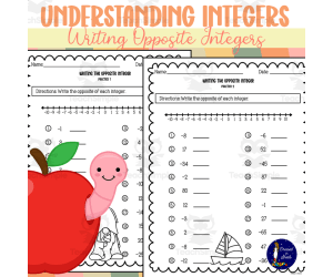
Understanding Integers: Writing Opposite Integers
Math, Early Math, Algebra, Number Lines, Numbers, Grade 5, 6, 7, Worksheets & Printables, Worksheets
Understanding Integers: Writing Opposite Integers Understanding Integers: Writing Opposite Integers is a comprehensive educational resource aimed at providing parents and educators with an effective teaching instrument. It facilitates familiarization with the concept of integers, specifically designed for students in grades 5 to 7. This tool leverages visual aids to help learners grasp the relative position of numbers on a number line, allowing them to differentiate between positive and negative integers easily. Included in the package: Four practice pages:The downloadable PDF features four separate pages aimed at exercises focusing on writing opposite integers. Each task intends to challenge your learner's understanding of positive and negative numbers. An answer key: Besides exercises, this resource offers an answer key that can assist teachers or homeschooling parents during review sessions or as a learning aid during student self-study hours. The key allows educators to correct common mistakes while discussing minor details impacting overall comprehension. This learning material is not confined just as another worksheet bundle but is an ensemble of exemplary activities suitable for group discussions or smaller groups based on class dynamics and teacher preference. Moreover, it works great as additional home practice or homework tasks strengthening lessons' assimilation. Henceforth, in content areas like Early Math Algebra Number Lines Numbers offered from Grades 5 through Grade 7 math classes, "Understanding Integers: Writing Opposite Integers" serves as a superlative supplementary tool boosting teaching efficiency while making learning about integers simpler than ever.
Author Soumara Siddiqui
Tags Integers, Opposite Integers, Number Line, Practice Activities, Answer Key
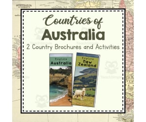
Countries of Australia | Continent of Australia Unit Study | Geography Bundle
Social Studies, Geography, Grade 3, 4, 5, 6, 7, Lesson Plans, Teacher Tools
Countries of Australia | Continent of Australia Unit Study | Geography Bundle This comprehensive resource explores the continent of Australia, diving deep into the geography and culture of two specific countries - Australia and New Zealand. It is designed to foster vibrant discussions about different cultures and smoothly incorporates into Social Studies or Geography curriculum for grades 3-7. What does this bundle include? Double-sided Brochures: Each country is represented in one brochure allowing students to explore aspects like food, language, attire, and famous landmarks. Mini Books: Learners can fill these with their discoveries about each nation's uniqueness. Fun Coloring Pages: Pages depict flags from both countries. Craft Pages: Students can decorate a boomerang celebrating Australia's indigenous heritage or design a Maori mask representing New Zealand's rich culture. To facilitate active involvement in exploration-based learning, passports are included for every student along with stamps symbolizing knowledge acquisition about each country. Supplementary reinforcement in geographical locations is provided by map work as well! An insightful unit test which covers key learnings from these resources is also part of this package. This ensures a thorough evaluation of your pupils' retention through this exciting journey across continents! Note: The package extends beyond just geography! Other informative cards available cover various elements associated with Australia such as its plants and animals. Postcards assignments covering Australian landmarks maybe assigned for added fun!! This unit study includes a zip file containing 23 ready-to-print PDF pages ensuring geographically enriching lessons. Additionally corresponding Google Documents are bundled making it usable for educators worldwide!
Author Simply Schoolgirl
Tags Australia, Continent Study, Geography, Culture, Unit Study
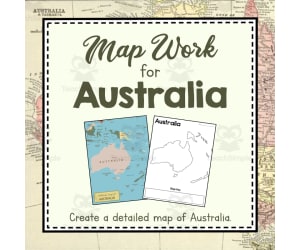
Map Work for Australia | Continent of Australia Unit Study | Geography Bundle
Social Studies, Geography, Grade 3, 4, 5, 6, 7, Lesson Plans, Teacher Tools
These map work activities and worksheets will help you teach about countries, land features, and how to make and use a map of Australia. Help your students create a beautiful detailed map to keep. Help them memorize and identify some of the Australian countries. *Please note that this is map work of the continent of Australia, which many people also know as the continent of Oceania. This resource covers the continent of Australia, not the country. How To Use This: Look through all the resources and decide which ones to use. Print the maps and follow the steps to create your own map of this continent. Practice labeling individual countries as part of your lesson. Then play a few games to reinforce your learning! Good luck in all your map making adventures! What You Get: - Political Map of Australia - Half-sheet Quick Facts about Australia - Teach Discussion Guide to use with Quick Facts About Australia - Label Countries in Australia worksheet and Answer Key - Blank Map of Australia Continent Template - 1 page map-making guide for students to follow as they make their map - Australia Map Work Word Search and Answer Key - 5 double-sided flashcards to help your students memorize Australian countries and landforms. Want More Australia Study Resources?: - Countries of Australia: Brochures and Activities - Plants of Australia: Informational Cards - Animals of Australia: Informational Cards - Map work for Australia - Postcards for Australia: Landmarks and Landforms - Australia Unit Test *I have resources like this for every continent. So make sure to check them out if your'e trying to put together a comprehensive geography study! Check out other resources from my store: Simply Schoolgirl! I can be contacted for questions and concerns at simplyschoolgirl1@gmail.com
Author Simply Schoolgirl
Tags Geography Lesson, Mapping Skills, Australia, Social Studies, Label A Map, Make A Map, Oceania, Guinea, New Zealand, Australia Map Continent, Simple Map Of Australia

Continent of Australia | Unit Study Test | Geography Bundle
Social Studies, Geography, Grade 3, 4, 5, 6, 7, Tests, Quizzes and Tests, Teacher Tools
The Continent of Australia | Unit Study Test | Geography Bundle This educational and comprehensive examination tool is designed for students wrapping up their study on Australia. Suitable for Grades 3 to Grade 7, this resource can be integrated seamlessly into any classroom or homeschool setup. Main Features: Multigraded approach: Catering to a range of student abilities. Social Studies Focus: Geographical understanding of Australia is the primary target. Flexible Delivery Options: Use as a group exercise, in study groups or assign as homework - your choice! Inclusive Test Format : Multiple-choice questions, fill-in-the-blanks and short answer queries ensure all learning abilities are catered for. } This PDF-format resource allows educators the freedom to print required pages at their own convenience thereby saving valuable prep-time which can then be devoted to lesson planning. The test contains detailed answers for all questions making it easy and swift to grade tests. More than just a time-saver, this bundle encourages children's curiosity about different world cultures and geographies - an essential step in creating future leaders who are aware of global issues and perspectives. Last but not least, given that similar resources are available covering every continent, this tool could easily become part of comprehensive global studies - making it an indispensable addition whether you're conducting thorough geography classes or simply trying to instil general world awareness among your students!
Author Simply Schoolgirl
Tags Australia, Geography, Unit Study, Test, Social Studies

Landmarks and Landforms of Australia | Continent Australia Unit Study | Geography Bundle
Social Studies, Geography, Grade 3, 4, 5, 6, 7, Lesson Plans, Teacher Tools
Enjoy 12 informative colorful postcards featuring famous landmarks and landforms found in Australia including The Great Barrier Reef, Bondi Beach, Uluru, Daintree National Forest, Sydney Opera House, Fraser Island, Sydney Harbour Bridge, Kakadu National Park, The Twelve Apostles, and The Great Ocean Road.. Each postcard is double sided with a beautiful photo on one side and a post-note on the other directed towards the students. Matching game with photos and clues to help students memorize and reinforce learning. PDF format. How To Use This: Look through all the resources and decide which ones to use. Print the postcards double sided (or print and lightly glue). Laminate for re-use. Use these as resources to learn about countries, landmarks, or landforms. Use them to write reports, or give oral presentations . Color and cut out stamps to put in your "Passport" to show you've learned about that country! Play the "I have, Who has" game as review! What You Get: - 12 double-sided landmark and landform information cards using metric measurements. - 12 double-sided landmark and landform information cards using imperial measurements. - 24 memory game cards to play with your students, picture of each landmark on one card, clues about the landmark on the other. Want More Australia Study Resources?: - Countries of Australia: Brochures and Activities - Plants of Australia: Informational Cards - Animals of Australia: Informational Cards - Map work for Australia - Postcards for Australia: Landmarks and Landforms - Australia Unit Test *I have resources like this for every continent. So make sure to check them out if your'e trying to put together a comprehensive geography study! Check out other resources from my store: Simply Schoolgirl! I can be contacted for questions and concerns at simplyschoolgirl1@gmail.com
Author Simply Schoolgirl
Tags Postcards, Social Studies, Landmarks, Oceania, Australian, Landforms, Outback, Great Barrier Reef, Bondi Beach, Uluru, Landmarks Of Australia, Geography Landmarks, Landmarks Australia
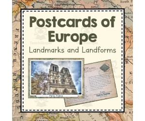
Landmarks and Landforms of Europe | Continent of Europe Unit Study | Geography Bundle
Social Studies, Geography, Grade 3, 4, 5, 6, 7, Lesson Plans, Teacher Tools
Enjoy 12 informative colorful postcards featuring famous landmarks and landforms found in Europe including The Notre Dame, The Eiffel Tower, The Pyrenees Mountains, The Leaning Tower of Pisa, The Colosseum, The Alps, The Sistine Chapel, Buckingham Palace, The Rhine River, Stonehenge, The Black Sea, and Blarney Castle.. Each postcard is double sided with a beautiful photo on one side and a post-note on the other directed towards the students. Play a "I Have...Who Has" game to help students memorize and reinforce learning. This resource is offered with both metric and imperial measurements How To Use This: Look through all the resources and decide which ones to use. Print the brochures double sided (or print and lightly glue). Laminate for re-use. Use these as resources to learn about countries, write reports, or give oral presentations. Color and cut out stamps to put in your "Passport" to show you've learned about that country! Do a craft or art project from each of the five focus countries! What You Get: 12 double-sided landmark and landform information cards using metric measurements. 12 double-sided landmark and landform information cards using imperial measurements. 12 "I Have....Who Has...." game cards for students to try and find matches based on photos and descriptions. A writing template for a report on their favorite landmark A 14 page mini-booklet (4 to a page) with space for students to write information and draw a picture of each landmark and landform. Want More Europe Study Resources?: - Countries of Europe: Brochures and Activities - Plants of Europe: Informational Cards - Animals of Europe: Informational Cards - Mapwork for Europe - Postcard for Landmarks and Landforms of Europe - Europe Unit Test *I have resources like this for every continent. So make sure to check them out if your'e trying to put together a comprehensive geography study! Check out other resources from my store: Simply Schoolgirl! I can be contacted for questions and concerns at simplyschoolgirl1@gmail.com
Author Simply Schoolgirl
Tags Europe, Social Studies, Geography Lesson, Brochures, United Kingdom, Landmarks, Landforms, Notre Dame, Eiffel Tower, Colosseum, Europe Is What Type Of Landform
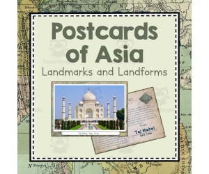
Landmarks and Landforms of Asia | Continent of Asia Unit Study | Geography Bundle
Social Studies, Geography, Grade 3, 4, 5, 6, 7, Lesson Plans, Teacher Tools
Landmarks and Landforms of Asia Unit Study Geography Bundle Dive into the world of Asian geography with our comprehensive teaching resource. This bundle is designed to introduce students to Asia's most notable landmarks and landforms through classroom instruction, group discussions, hands-on activities or homework assignments. What's Included? A set of 12 double-sided cards, showcasing a famous location such as The Great Wall of China or Mount Fuji. On the reverse side, you will find an informational note targeted for students in both metric and imperial measurements. A colourful student booklet, complete with photos that learners can affix themselves providing a personal touch. Each site includes space for notes about its characteristics and significance. A unique 'Pupil Passport,' incorporating fun elements like stamps pupils cut out after learning each country's landmarks & landforms. An engaging game called 'I have, Who has?' - putting an exciting spin on regular review sessions by incorporating 12 popular locations across Asia. This product caters well to elementary through middle school age range (Grade 3-7) under Social Studies focusing primarily on Geography units. Each download includes multiple file types packed within one zip file: images previewing product content along with a full-colored printable PDF consisting 37 pages. Use this package progressively over a semester or throughout unit studies to cultivate an extensive understanding in Asian geography – thereby preparing students not just academically but encouraging global awareness as well. Simplify your lesson planning today with this delightful bundle - making learning about Asia's landmarks and landforms both effective, diverse & intriguing!
Author Simply Schoolgirl
Tags Geography, Asia, Landmarks, Landforms, Learning
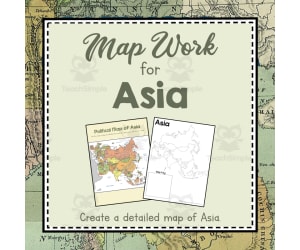
Map Work of Asia | Continent of Asia Unit Study | Geography Bundle
Social Studies, Geography, Grade 3, 4, 5, 6, 7, Lesson Plans, Teacher Tools
Map Work of Asia | Continent of Asia Unit Study | Geography Bundle This is a comprehensive resource designed for educators and homeschoolers teaching geography to Grade 3 to Grade 7 students. This unique tool offers activities and worksheets that engage learners in understanding the vast and diverse continent of Asia. Uses: Classroom integration in various setups such as whole group discussions or small group activities Suitable for homework assignments Ideal for after-school programs or summer camps Contents: A politically accurate map of Asia enriched with quick facts about the continent. An instructor's guide on how best to present these facts. Labeling activity of distinct Asian countries with an answer key. Mapped word searches exclusively centered around Asia. Note: As a bonus, there are flashcards aiding memory retention especially useful when dealing with identification and locational memorization of 13 diverse Asian countries! If your scope expands beyond geography or includes other continents, look out for additional brochures detailing specific nations across those continents as well as informational cards on local flora & fauna. Postcard sets showcasing famous landmarks can fire up curiosity among young learners too! The bundle comes in multiple file formats ensuring easy access across different platforms - insightful geographic knowledge just a click away! Taking geography from being just textbook content to becoming an engaging exploration tool, this bundle is truly dynamic and comprehensive!
Author Simply Schoolgirl
Rating 5
Tags Asia, Map Work, Continent Study, Geography Bundle, Countries

Countries of Asia | Continent of Asia Unit Study | Geography Bundle
Social Studies, Geography, Grade 3, 4, 5, 6, 7, Lesson Plans, Teacher Tools
Countries of Asia | Continent of Asia Unit Study | Geography Bundle Embark on an exciting journey to explore the diverse countries in the massive continent of Asia with this comprehensive geography bundle! This resource is primarily designed for students from grades 3 to 7. It features five detailed brochures filled with engaging photographs and valuable information about five prominent countries: China, Japan, India, Israel, and Russia. Dive Deeper into Culture The package delves into the unique customs and culture of these nations. Students will discover staple foods, distinctive local attire,and languages while also learning about what each country is famous for. Such an immersive experience may spark a newfound interest in travel or international affairs among young learners! The study material has been developed considering various teaching methodologies - it can be used as a whole group activity during lessons, small group assignments, or even as homework. Ease Of Use The brochures are designed easy-to-print, double-sided bifold templates which optionally can be laminated for long term reuse across different batches of students. A Fun and Engaging Journey Your students can color out mini flags and stamps related to these countries. These creative elements can be incorporated while creating Passports that showcase their extensive geographic knowledge! We envisage making learning more enjoyable by integrating craft activities like Chinese calligraphy or origami folding – not merely as memorable learning tools but also infusing hands-on artistry which children will thoroughly enjoy. This Comprehensive Set Includes: In-depth mini books about each focus country Additional coloring pages showcasing national flags of these nations A template to make paper Menorahs, helping bring bits of diverse life directly into the classroom! In summary, this geography bundle aims to deliver comprehensive understanding through interactive methods that not only nurture curiosity but also promote creativity among young minds as they explore the richness of Asia. Whether you're preparing them for geography tests or simply encouraging them to appreciate world cultures, this resource will be a valuable addition. Experience the joy of enabling your students to 'travel' & learn all from the comfort their classroom! Unlock your student's potential today!
Author Simply Schoolgirl
Tags Asia Countries, Geography Bundle, Continent Study, Cultural Immersion, Hands-on Learning
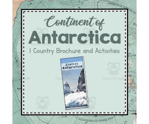
Continent of Antarctica | Continent of Antarctica Unit Study | Geography Bundle
Social Studies, Geography, Grade 3, 4, 5, 6, 7, Lesson Plans, Teacher Tools
Continent of Antarctica Unit Study | Geography Bundle The 'Continent of Antarctica Unit Study | Geography Bundle' is not just a teaching resource, but a world exploration guide for eager learners. Designed with an interactive and engaging approach, it caters to students from the 3rd grade to the 7th grade focusing predominantly on social studies and specifically geography. About this bundle: The content revolves around everything that makes up Antarctica. A comprehensive brochure filled with vivid photos and detailed descriptions about this icy continent serves as the main attraction, providing kids with real-life visual connections. Moreover, this self-contained bundle holds activities such as: Creating a fact cube, Coloring the flag of Antarctica, Filling out passport pages after studying each portion Assembling an admirable penguin art project . Nurturing Creativity: The unit gives room for students not only to learn but also express their understanding through writing about what they have learned in mini-booklet provided. Educational Benefits: The bundle boasts variations of brochures using metric and imperial measurements along with a colorful political map of Antartica. These features can help dust off any uncertainties related to numerical terms while educating young minds about international political landscapes. Ease Of Use! This resource easily integrates into various learning scenarios – whole group class presentations where everyone learns together; small groups where focused discussion is pivotal; individual assignments at home strengthening retention; or even homeschooling environment sharpening kids' independent research skills. Laminating these knowledge-rich papers can lead them towards longer utility making every bit worth your time & effort invested in creating meaningful learning experiences for your pupils. Wrapping Up: The 'Continent of Antarctica Unit Study | Geography Bundle', with its variety, depth and adaptability stands ready to supplement any teaching methodology making geography both a comprehensive and lively subject for young scholars. Embrace your next journey towards Antarctic exploration with this well-rounded resource in hand, ensuring you cater to the diverse learning needs of your students effortlessly.
Author Simply Schoolgirl
Tags Antarctica, Unit Study, Geography, Interactive, Hands-on, Continent Study, Antarctica Lesson Plans
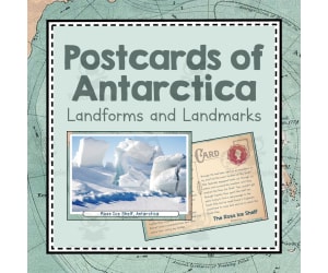
Landmarks and Landforms of Antarctica | Continent of Antarctica Unit Study
Social Studies, Geography, Grade 3, 4, 5, 6, 7, Lesson Plans, Teacher Tools
9 postcards featuring landmarks and landforms found in Antarctica. Set comes with 9 activity pages, 1 worksheet , 1 fact cube template, and 1 report template so students can practice, enjoy, and reinforce skills. Each postcard is double sided with a beautiful photo on one side and a post-note on the other directed towards the students. Don't worry- this product comes in both metric and imperial measurement systems so you can enjoy no matter how you measure! This is a fantastic way to study landmarks and landforms of the Antarctic continent during your Antarctica unit study! How To Use This: Look through all the resources and decide which ones to use. Print the postcards double sided (or print and lightly glue). Laminate for re-use. Use these as resources to learn about countries, landmarks, or landforms. Use them to write reports, or give oral presentations. Color and cut out stamps to put in your "Passport" to show you've learned about that country! Play the "I have, Who has" game as review! What You Get: 9 double sided postcards of landmarks and landforms using the metric measurement system. 9 double sided postcards of landmarks and landforms using the imperial measurement system. 9 half-page activities for each landmark and landform Fill in the Blank worksheet 1 fact cube to fill out and assemble 1 report template Want More Antarctica Study Resources?: - Continent of Antarctica: Brochure and Activities - Plants of Antarctica: Informational Cards - Animals of Antarctica: Informational Cards - Map work for Antarctica - Postcards for Antarctica: Landmarks and Landforms - Antarctica Unit Test *I have resources like this for every continent. So make sure to check them out if your'e trying to put together a comprehensive geography study! Check out other resources from my store: Simply Schoolgirl! I can be contacted for questions and concerns at simplyschoolgirl1@gmail.com
Author Simply Schoolgirl
Tags Postcards, Antartica, Geography Lesson, Landmarks, Fill In The Blank, Ross Ice Shelf, Arctic Circle, North Pole, Antarctic Landmark, Antarctica Landmark

Map Work of Antarctica | Continent of Antarctica Unit Study | Geography Bundles
Social Studies, Geography, Grade 3, 4, 5, 6, 7, Lesson Plans, Teacher Tools
Map Work of Antarctica | Continent of Antarctica Unit Study | Geography Bundles A comprehensive teaching resource that educates students about the unique geography of the southernmost continent. It's perfect for educators working with Grade 3-7. Clear, concise information is combined with engaging visual aids and interactive elements to make learning super appealing and accessible. Creating Detailed Map of Antarctica: This unit begins by guiding students through creating their own detailed map of Antarctica It teaches essential mapping skills like understanding keys, compass roses etc. To deepen their understanding, students will mark significant features on their maps such as: Ice shelves Volcanoes The South Pole locations etc. Educational Tools: Flashcards:This bundle integrates flashcards into the study unit program to reinforce terrain recognition skills while stimulating memory retention. Mapped diagram in digital formats included! Oftentimes a printable template is available too. Contact Information: Reach out at simplyschoolgirl1@gmail.com for any questions or concerns.
Author Simply Schoolgirl
Tags Map Skills, Antarctica Geography, Mapping Activities, Flashcards, Discussion Questions
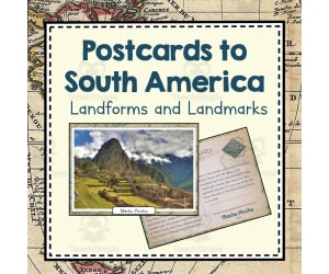
Landmarks and Landforms of South America | Continent of South America Unit Study | Geography Bundle
Social Studies, Geography, Grade 3, 4, 5, 6, 7, Lesson Plans, Teacher Tools
Postcards featuring famous landmarks and landforms found in South America including: Lake Titicaca, Los Pampas, Machu Picchu, Mount Cotopaxi, Amazon Rainforest, Cueva de los Manos, Cape Horn, Galapagos Islands, Easter Island, Ancient City of Chan Chan, Angel Falls, Andean Mountains, Christ the Redeemer, Rio de Janeiro, and Salar de Uyuni. Set comes with worksheet for each landmark and landform so students can practice, enjoy, and reinforce skills. Each postcard is double sided with a beautiful photo on one side and a post-note on the other directed towards the students. All these postcards are provided using both the metric and imperial measurement systems, so you can enjoy no matter how you measure! How To Use This: Look through all the resources and decide which ones to use. Print the postcards double sided (or print and lightly glue). Laminate for re-use. Use these as resources to learn about countries, landmarks, or landforms. Use them to write reports, or give oral presentations. Color and cut out stamps to put in your "Passport" to show you've learned about that country! Play the "I have, Who has" game as review! What You Get: - 15 double sided postcards using the metric measurement system. - 15 double sided postcards using the imperial measurement system. - A worksheet for each landmark or landform. Want More South America Study Resources?: - Countries of South America: Brochures and Activities - Plants of South America: Informational Cards - Animals of South America: Informational Cards - Map work for South America - Postcards for South America: Landmarks and Landforms - South America Unit Test *I have resources like this for every continent. So make sure to check them out if your'e trying to put together a comprehensive geography study! Check out other resources from my store: Simply Schoolgirl! I can be contacted for questions and concerns at simplyschoolgirl1@gmail.com
Author Simply Schoolgirl
Tags Landmarks, Landforms, South America, Postcards, Geography Lesson, Famous Places, South American, Machu Picchu, Andes, Titicaca, Important Landmarks In South America, Landmarks In South America, Antarctica Important Landmarks, Important Landmarks In Antarctica, Famous Landmarks In Latin America, Famous Landmarks Of South America, Famous Landmarks South America, Famous Landmarks In South America

Countries of North America | Continent of North America Unit Study | Geography Bundle
Social Studies, Geography, Grade 3, 4, 5, 6, 7, Lesson Plans, Teacher Tools
The Countries of North America | Continent of North America Unit Study | Geography Bundle The Countries of North America bundle is a comprehensive teaching resource that delves deep into the cultures, geographies, and landmarks of five major North American countries: the United States, Mexico, Canada, Panama and Costa Rica. Double-sided brochures: Detailed descriptions about each country's language, food habits, clothing styles and other key features. Available in both metric and imperial system measurements. National color flags: Useful for map referencing or student-initiated passports. National flag coloring pages: Engaging activities that help students understand more about a nation's symbolism. A political map of North America (Worksheet Included): Encourages labelling exercises to consolidate knowledge about different countries' positions within the continent. Craft instructions linked with each country are available as well - from making chocolate sequences in Costa Rica to designing Dios de los Muerto's skulls for Mexico! Mini books & Infographic-styled brochures: Tactile learning tools perfect for report writing sessions or oral presentation prep centered around each featured nation. "Passport-like" templates: : &nbp★▼p>★ ●</b
Author Simply Schoolgirl
Tags North America, Geography, Countries, Cultures, Landmarks, Geography Unit Study

Landmarks and Landforms of North America | Continent of North America Unit Study | Geography Bundle
Social Studies, Geography, Grade 3, 4, 5, 6, 7, Lesson Plans, Teacher Tools
12 postcards featuring famous landmarks and landforms found in North America. Set comes with worksheet for each landmark and landform so students can practice, enjoy, and reinforce skills. Each postcard is double sided with a beautiful photo on one side and a post-note on the other directed towards the students. Don't worry, I've provided both systems of measurement: the metric and imperial systems so no matter where you live- I've got you covered. How To Use This: Look through all the resources and decide which ones to use. Print the postcards double sided (or print and lightly glue). Laminate for re-use. Use these as resources to learn about countries, landmarks, or landforms. Use them to write reports, or give oral presentations. Color and cut out stamps to put in your "Passport" to show you've learned about that country! Play the "I have, Who has" game as review! What You Get: - 12 double-sided information cards about famous landmarks and landforms in North America using the metric measurement system. - 12 double-sided information cards about famous landmarks and landforms in North America using the imperial measurement system - 12 half-sheet worksheets to go along with each postcard Want More North America Study Resources?: - Countries of North America: Brochures and Activities - Plants of North America: Informational Cards -Animals of North America: Informational Cards -Map work for North America - Postcards for North America: Landmarks and Landforms - North America Unit Test *I have resources like this for every continent. So make sure to check them out if your'e trying to put together a comprehensive geography study! Check out other resources from my store: Simply Schoolgirl! I can be contacted for questions and concerns at simplyschoolgirl1@gmail.com
Author Simply Schoolgirl
Tags Landmarks, Landforms, Geography Lesson, Mexico, Postcards, United States, Famous Places, Tourism, Canada, Statue Of Liberty, North America Landforms Map, Land Marks In North America, North America Famous Landmarks, North American Landmarks, Us Landforms Worksheet, North America Landmarks, North America Land Marks, Landmarks North America, Famous Landmarks In North America, Landmarks In North America

Map Work for North America | Continent of North America Unit Study | Geography Bundle
Social Studies, Geography, Grade 3, 4, 5, 6, 7, Lesson Plans, Teacher Tools
Map work activities and worksheets for North America will help your student become more familiar with North American countries, important landforms, and creating and using maps. Help your students create a beautiful detailed map to keep. Help them memorize and identify some North American countries. I have worked hard to provide enough resource options so that you can pick and choose and create a personalized and thorough approach! How To Use This: Look through all the resources and decide which ones to use. Print the maps and follow the steps to create your own map of this continent. Practice labeling individual countries as part of your lesson. Then play a few games to reinforce your learning! Good luck in all your map making adventures! What You Get: - Political Map of North America - Half-sheet Quick Facts about North America - Teach Discussion Guide to use with Quick Facts About North America - Label Countries in North America worksheet and Answer Key - Blank Map of North America Continent Template - 1 page map-making guide for students to follow as they make their map - North America Map Work Word Search - 14 double-sided flashcards to help your students memorize 9 North American countries and several prominent landforms. Want More North America Study Resources?: - Countries of North America: Brochures and Activities - Plants of North America: Informational Cards -Animals of North America: Informational Cards -Map work for North America - Postcards for North America: Landmarks and Landforms - North America Unit Test *I have resources like this for every continent. So make sure to check them out if your'e trying to put together a comprehensive geography study! Check out other resources from my store: Simply Schoolgirl! I can be contacted for questions and concerns at simplyschoolgirl1@gmail.com
Author Simply Schoolgirl
Tags Mapping, Blank Map, Geography Worksheet, North America, Landforms, Cartography, Make A Map, Label Countries, Continent, Geography Maps Of North America, Continent Of North America Map, Map Of North America Continent, North America Geography Map, North America Map Geography

Map Work for South America | Continent of South America Unit Study | Geography Bundle
Social Studies, Geography, Grade 3, 4, 5, 6, 7, Lesson Plans, Teacher Tools
Map Work for South America | Continent of South America Unit Study | Geography Bundle Description The Map Work for South America | Continent of South America Unit Study | Geography Bundle is an extensive collection of resources aimed at educating students about the geography and distinct characteristics of this fascinating continent. This bundle includes a variety of engaging map work activities suitable for grades 3 to 7. The primary focus is on project-based learning, motivating students to self-assemble their maps as they memorize the geographical details. A map-building guide coupled with a blank template fosters hands-on learning about countries' locations and terrain in the continent. A wide range of worksheets within this bundle deepen students’ understanding, such as "Labelling Countries Worksheet" along with its respective answer key. "Quick Facts - Half-sheet", an excellent tool prompting interactive classroom discussions while serving as enriching homework assignments too. The resource set also includes memory-enhancement activities: A fun "South American Countries Word Search game". Innovative double-sided flashcards featuring 20 key locations—proven effective when teaching in groups. To assist in illustrating geopolitical boundaries within the continent: Detailed political boundary outlines for every country are included, making it an invaluable visual aid during social studies classes. Note: Resources are not solely paper-based; they accompany as digital copies both as PDFs and Google Docs adding flexibility regarding sharing or printing tasks based on individual needs in classrooms or homeschool settings. Suitability and Usage Leverage these resources during any comprehensive geographical study involving active participation across diverse learning styles. Whether for whole group discussions or small group projects, the bundle can be extremely beneficial. Don’t forget to explore similar bundles based on other continents for a more globally-focused geography education!
Author Simply Schoolgirl
Tags South America, Map Work, Geography Unit, Countries, Physical Features, Map Of South America Continent

Countries of South America | Continent of South America Unit Study | Geography Bundle
Social Studies, Geography, Grade 3, 4, 5, Lesson Plans, Teacher Tools
Countries of South America | Continent of South America Unit Study | Geography Bundle This comprehensive resource is designed to immerse students in an in-depth exploration of the countries within the continent. It includes a range of activities aimed at fostering better understanding and appreciation for cultural diversity. This unit study covers crucial subjects such as: Food Dress Code Language Spoken Prominent Features and more.... Country-Specific Overviews: The unit focuses on individual countries including Brazil, Peru, Argentina, Venezuela, and Chile, allowing students to closely examine each unique culture. The package includes: Five double-sided brochures featuring two measurement systems. Five flag coloring pages correlating with the featured countries. Inclusive Activities: The fact cube template and the brochure template encourage creativity while reinforcing newly acquired knowledge. Art projects from each highlighted country round off this geography bundle - providing a fun yet educational journey through South America. A Fun Aspect to Learning: To make lessons more engaging, we have included a student passport with accompanying passport stamps for each country learned about. This brings a playful aspect into learning geography similar to real-world travel where you collect stamps from different locations! Versatility: This teaching tool can be used flexibly—for whole-class instruction or small groups in various classroom settings or even at home for distance learners or homeschooling options. In summary: This tailored package contains all necessary materials for an exciting and informative geographic expedition. It promotes cross-cultural competency and makes social studies meaningful and fun!
Author Simply Schoolgirl
Tags South America, Continent Study, Geography, Cultural Diversity, Hands-on Learning