2,800 products added recently
Page 630 - Newest Teaching Resources

Nonfiction Text Features: Title Lesson
ELA, Reading, Grade 1, 2, 3, 4, Teacher Tools, Lesson Plans
Nonfiction Text Features: Title Lesson Plan This engaging Google Slides resource teaches students about the key nonfiction text feature - the title. Through class discussions and practice activities, students will learn how to identify titles and apply this knowledge. Animated slides explain what a title is and how it is used in nonfiction texts. Additional student slides provide opportunities for further practice. This resource can be used to introduce or review the concept of titles in an interactive small group or whole class setting. Extend student learning by using the additional nonfiction text features lessons linked at the end, covering topics like captions, glossaries, and more. This reading resource helps build nonfiction comprehension in grades 1-4.
Author Ezee 101
Tags Title, Text Features, Nonfiction, Interactive Reading
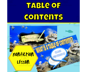
Nonfiction Text Features: Table of Contents Lesson
ELA, Reading, Grade 1, 2, 3, 4, Teacher Tools, Lesson Plans
Nonfiction Text Features: Table of Contents Lesson Plan This interactive Google Slides resource teaches students about the table of contents nonfiction text feature. Through discussions and activities, students will learn how to identify, understand, and apply tables of contents. The resource includes animated lesson slides with speaking notes to introduce or recap the key concepts. Student slides provide opportunities for practice during or after the lesson. Students will apply reading, critical thinking, and problem solving skills as they work. The slides aim to actively engage students using a variety of learning modalities. They can be presented to the whole class or assigned to small groups or individual students. The resource is designed for grades 1-4 language arts or reading classes, but could be adapted for other grades and subjects.
Author Ezee 101
Tags Nonfiction, Text Features, Table Of Contents, Lesson Plans, Student Activities, Interactive, Engaged
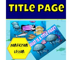
Nonfiction Text Features: Title Page Lesson
ELA, Literature, Grade 1, 2, 3, 4, Teacher Tools, Lesson Plans
Introducing a Grade 1-4 Language Arts lesson on nonfiction text features - specifically, title pages. Educators can use this animated and interactive Google Slides presentation to introduce or review what a title page is, why it's important in nonfiction texts, and how to identify a good title page. Students will participate in class discussions and activities applying their reading, critical thinking, and problem-solving skills. Lesson slides contain speaker notes while student slides allow independent or group work during or after the lesson. This concise yet thorough resource aims to concretely build students' understanding of nonfiction text structure. For more nonfiction text lessons, see the additional Google Slides resources on captions, glossaries, tables of contents, titles, title pages, and indexes.
Author Ezee 101
Tags Nonfiction, Text Features, Title Page, Glossary, Interactive Reading
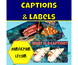
Nonfiction Text Features: Captions and Labels Lesson
ELA, Reading, Preschool, Grade 1, 2, 3, Lesson Plans, Teacher Tools
Nonfiction Text Features: Captions and Labels Lesson Plan This interactive Google Slides resource teaches students about captions and labels, two key text features found in nonfiction books. Through discussions, activities, and practice exercises, students will learn how to identify captions and labels and apply them in their own writing. Animated slides, speaker notes, and student task slides allow flexibility to use this resource for whole-group instruction, small-group work, or independent practice during class or as homework. This concise yet engaging lesson plan aims to deepen third graders' understanding of nonfiction text structures. It can serve as an introduction or refresher on this topic. Check out other nonfiction text features lessons from this shop covering glossaries, tables of contents, titles, title pages, and indexes.
Author Ezee 101
Tags Nonfiction, Text Features, Reading, Strategies, Captions, Labels, Lesson, Activities

Country Study on South Korea - Research Project - Worksheet + Cards
Social Studies, History, History: Asian, Geography, Research, Grade 7, 8, 9, 10, 11, 12, Projects, Activities
Country Study on South Korea - Research Project - Worksheet + Cards This Teaching Resource is a PDF research project (9 Slides) on South Korea. This Printable Resource can be great for Geography, Asian History and Social Studies Classes. Suitable Learners for this kind of lesson are students from 7th Grade to 12th Grade. This Geography + Social Studies Research Project on South Korea (Country Study) aims to make learners discover South Korea (history, geography, economy, Seoul and culture). Little preparation can be helpful. Within this Country Study on South Korea Research Project, it is offered: 2 worksheets to write research outcomes 56 Cards to fish for this Research Project on South Korea How does this Country Study on South Korea Teaching Resource work? learners (or groups) fish a Research Topic card of each color (black for history, blue for geography, orange for economy, Red for Seoul and green for Korean Culture) each student or group makes their personalized Research on South Korea, by focusing on their fished topic cards (ex. fished black card on history on "Gwanju Uprising", blue card on geography on "Rice Production in South Korea", orange card on economy on "Tertiary Sector", Red Card on Seoul on Dongdaemun Design Plaza and a green card on Korean Culture on K-Pop) Learners stick their fished cards on their research worksheet and write their Research outcomes Learners make a presentation on their personalized rersearch on South Korea teacher evaluates research given learner or group's research outcomes written on worksheets Why is this Teaching Resource worth using? By fishing topic cards, students have a chance to: make unique randomized research projects focus on specific topics only and discover more the research country in "non-superficial" ways Connect their own Research outcomes with their peers' This Social Studies + Geography Country Study on South Korea PDF Printable Research Project Teaching (9 slides) can be great for learners from 7th grade to 12th grade to introduce South Korea and its Culture. Learning with Alan is a Brand New Teaching Resource/Educational Material Store whose aim is to help Teachers, Educators and Tutors to achieve their teaching objectives while creating a fun and stimulating environment. Never Forget! If you want to browse more of my Teaching Resources, click here Learning with Alan!
Author Learning with Alan
Tags South Korea, Asia, Research, Project, Worksheet, Cards, Asian History, Geography, Social Studies, Country Study

Country Study on South Korea - Snakes and Ladders Board Game PDF
Social Studies, History, History: Asian, Geography, Grade 7, 8, 9, 10, 11, 12, Activities, Games
Country Study on South Korea - Snakes and Ladders Board Game PDF This Teaching Resource is a PDF Board game (Snakes and Ladders; 3 slides) on South Korea (Asia). This Printable Resource can be great for Geography, Asian History and Social Studies Classes. Suitable Learners for this kind of lesson are students from 7th Grade to 12th Grade. This Geography + Social Studies game on South Korea (Country Study) aims to test learners on their knowledge on South Korea and Korean Culture (naming 2 Korean cities, telling about history events, telling about your pawn's character, telling about Famous Korean individuals or telling what you would like to visit if you had to go to South Korea). Some preparation on South Korea, Korean Culture and History can be useful for this Social Studies Activity. Within this amazing Country Study on South Korea (Asia) board game (snakes and ladders; 3 PDF Printable slides) it is offered: 1 board with questions and Speaking Prompts (ex. naming Korean Cities or telling about Korea's history events such as the Korean War, Sejong the Great, the 1st March Movement etc) 1 Printable Craft Die with numbers written 1 Printable Craft cone to make Game Pawns to play 5 Famous People from South Korea (Bong Joon-ho, Queen Min, Sejong the Great, Ban Ki-moon etc.) to stick on the players' printable craft cone This amazing and fun Social Studies + Geography Country Study on South Korea (Asia) PDF Digital Teaching Resource (3 PDF Printable Slides) can be great for learners from 7th grade to 12th grade to test South Korea and Korean Culture. Learning with Alan is a Brand New Teaching Resource, Educational Material Store whose aim is to help Teachers, Educators and Tutors to achieve their teaching objectives while creating a fun and stimulating environment. Never Forget! If you want to browse more of my Teaching Resources, click here Learning with Alan
Author Learning with Alan
Tags South Korea, Asia, Geography, Asian History, Social Studies, Snakes And Ladders, Board Game, Printable, Game, Korea

Country Study on South Korea - Guess Who Game Cards on Famous Koreans
Social Studies, Geography, History, History: Asian, Grade 6, 7, 8, 9, 10, 11, 12, Activities, Games
Country Study on South Korea - Guess Who Game Cards on Famous Koreans This Teaching Resource is a fun Guess Who Game PDF (1 slide, 15 cards) on Famous Korean People. This Printable Resource can be great for Geography, Asian History and Social Studies Classes. Suitable Learners for this kind of lesson are students from 6th Grade to 12th Grade. This Geography + Social Studies Guess Who Game on Famous People from South Korea (Country Study) aims to introduce learners to South Korea and its most famous Koreans (leaders, film makers, politicians, music groups, singers etc.). Little Preparation is needed for this Social Studies + Geography Activity. Some of the Korean People selected for this Geography + Social Studies + Asian History Country Study on South Korea are: Sejong the Great (Monarch and creator of Korean Writing System Hangul) Kim Dae-jun (President of South Korea) BTS (K-Pop Boy Band) Blackpink (K-Pop Band) BoA (Singer) June Huh (Mathematician) Bong Joon-ho (Academy Award Film Maker; "Parasite") Ban Ki-moon (UN Secretary-General and Politician) Queen Min (Korean Monarch) and many more! A very fun and engaging way to play this "Guess Who on Famous People from South Korea" (country study on South Korea) game can be the following: all Learners sit on the floor in a circle every Learner has a Flash Card on their face every Learner/player asks a question about their Flash Card 's famous Korean This Social Studies + Geography Country Study on South Korea PDF Printable Teaching Resource (1 slide, 15 cards for 15 Famous People from Korea) can be great for learners from 6th grade to 12th grade to introduce South Korea and its Culture through its most important and celebrated people. Learning with Alan is a Brand New Teaching Resource/Educational Material Store whose aim is to help Teachers, Educators and Tutors to achieve their teaching objectives while creating a fun and stimulating environment. Never Forget! If you want to browse more of my Teaching Resources, click here Learning with Alan!
Author Learning with Alan
Tags South Korea, Asia, Famous People, Geography, Social Studies, Country Study, Guess Who, Cards, Game, Printable

Funky Fingers fine Motor Skills Challenges
ELA, Writing, Handwriting, Kindergarten, Preschool, Grade 1, Activities
Developing fine motor skills lays the foundation for pencil grasp, legible handwriting and manipulation tasks. These Fine Motor Skills Challenges provide a fun-filled way to build hand strength, dexterity and control. This set includes 36 activity cards that target key skills. Each card features a unique fine motor exercise using engaging materials like pompoms, beads, strings, locks and keys. Kids will love practicing with the tactile toys! Also included are printable templates to support many of the challenges, these include: Gingerbread men to tweezer buttons onto Large numbers to place sequins on Hole punch activity Jellybean jars Geoboard number templates Gumball machines Muffin tray templates Tags for padlocks and keys Pompom ice creams Pompom pictures Numbers for threading Students can rotate through the Fine Motor Skills Challenges independently at a specialized station or table. Teachers can also use the cards to assign differentiated tasks to children needing extra practice grasping small items or maintaining precision. The self-correcting activities allow for repeated practice to increase dexterity. This comprehensive collection of research-based challenges will strengthen the small muscles needed for cutting, lacing, buttoning, writing and more. Early childhood educators, occupational therapists and parents will find these activities perfect for promoting proficiency and confidence in fine motor skills. Clipart images courtesy of Kari Bolt Clipart and Krista Wallden Creative Clips
Author SEN Resource Source
Tags Fine Motor, Hand-eye Coordination, Finger Strength, Motor Skill Challenges, Manipulative Exercises, Occupational Therapy, Grasping Skills, Hand Manipulation, Coordination Challenges
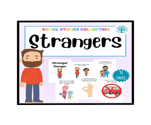
Stranger Danger Social Story
Special Resources, Life Skills, Social Skills, Special Education Needs (SEN), Not Grade Specific, Activities
Teaching children about stranger safety is crucial, but can be a scary topic. This Stranger Danger Social Story takes the fear out of this important lesson by using a warm, straightforward approach. Designed for preschool and elementary age kids, this social story clearly defines "stranger" and explains why children should never go anywhere with someone they don't know. It covers strangers in different situations, like if approached on the street, in a store or playground. Kids learn that strangers can trick them with offers of candy, pets or fun activities. Importantly, this Stranger Danger story also teaches children what to do if a stranger tries to interact with them. It provides simple steps like saying "No!", running to a trusted adult, yelling for help and reporting it right away. The empowering message is: Your body is yours and no one can take you without permission. With its therapeutic tone and real-world advice, this social story removes anxiety and arms children with strategies. It is an indispensable tool for teachers, counselors, social workers and parents wanting to broach this sensitive safety issue. Using concrete examples and a reassuring voice, this Stranger Danger guide will build awareness, confidence and essential skills to help keep kids secure.These books should be used over and over to reinforce the point so I would suggest either putting the pages into a display book or laminating and binding them. Clipart images courtesy of Kari Bolt Clipart
Author SEN Resource Source
Tags Stranger, SEN, Social Skills, Autism, Social Story, Social Narrative

Riding the School Bus Social Story
Special Resources, Life Skills, Social Skills, Special Education Needs (SEN), Not Grade Specific, Activities
For many students, riding the school bus can cause uneasiness and uncertainty. This Riding the School Bus Social Story is designed to alleviate anxiety by clearly explaining what to expect before, during and after the bus ride. Using a reassuring tone and relatable imagery, this social story walks children through bus transportation from start to finish. It covers key steps like waiting at the stop, boarding the bus, sitting properly in a seat, following safety rules, and disembarking at school. The story also provides tips for staying calm, avoiding distractions and getting help if needed. By articulating every detail of the process, this social story reduces fear of the unknown. Teachers can review it with individuals or small groups to set expectations and impart skills like following directions, seat safety and asking for assistance. The step-by-step breakdown and supportive tone build confidence in even the most apprehensive riders. An invaluable inclusion resource, this Riding the School Bus Social Story promotes independence and eases transition jitters. It is ideal for special education teachers, counselors, therapists and parents supporting neurodiverse learners or children with behavioral struggles. Provide this social story to students before the first bus ride to curb anxious feelings and pave the way for a positive school year. These books should be used over and over to reinforce the point so I would suggest either putting the pages into a display book or laminating and binding them. Clipart images courtesy of Artifex
Author SEN Resource Source
Tags Social Story, Riding The Bus, SEN, Autism, Social Narrative
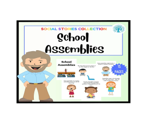
School Assemblies Social Story
Special Resources, Life Skills, Social Skills, Special Education Needs (SEN), Not Grade Specific, Activities
School assemblies can be overwhelming for some students who struggle with changes to routine or large, noisy gatherings. That's why this School Assemblies Social Story is an invaluable tool for easing anxiety and promoting skills. Social stories use simple language and visuals to walk children step-by-step through challenging situations. This school assemblies story uses a reassuring tone and eye catching pictures to explain what assemblies are, who attends them, what to expect, and tips for coping. The story covers arriving at the assembly, sitting quietly, appropriate responses, avoiding distractions, and more. Using concrete examples and positive reinforcement, this social story builds understanding of assembles as well as skills like following directions, focus, and self-regulation. Teachers can review the story with individuals or small groups to reduce apprehension and prevent sensory overload. The clear explanations and real-world scenes help students know what to anticipate. With its therapeutic approach, this School Assemblies Social Story fosters confidence, independence and inclusion. It is an excellent resource for special education teachers, counselors, and other professionals supporting neurodiverse learners or students with behavioral challenges. By articulating social expectations in a comprehensive yet accessible way, this story empowers children to successfully participate in assemblies. These books should be used over and over to reinforce the point so I would suggest either putting the pages into a display book or laminating and binding them. Clipart images courtesy of Kari Bolt Clipart
Author SEN Resource Source
Tags Social Story, SEN, Autism, Assembly, School Assemblies, Social Narrative

Strength Cards
Special Resources, Social Emotional Learning (SEL), Special Education Needs (SEN), Social Skills, Not Grade Specific, Activities
nstilling confidence and self-esteem in students starts with helping them recognize and appreciate their own unique strengths. These Strength Cards are the perfect tool to foster positive self-image and empowerment. The set includes 48 cards each featuring an uplifting strength word. Included words are: graceful, sporty, brave, funny, caring, clever, helpful, playful, friendly, musical, intelligent, happy, loving, creative, artistic, strong, honest, respectful, adventurous, patient, joyful, sensible, cheerful, gentle, calm, protective, resilient, reliable, responsible, curious, persistent, forgiving, enthusiastic, hopeful, assertive, courageous, energetic, fair, organised, imaginative, proud, active, ambitious, careful, co-operative, hard working, loyal and kind. The diverse mix of attributes encompasses social, emotional, intellectual and physical strengths to represent the well-rounded potential of every child. Students can use these cards for self-reflection, goal setting, praise and affirmation exercises. Teachers can incorporate Strength Cards into lessons on growth mindset, self-confidence, kindness and more. Have students draw a card and share a time when they exhibited that strength. Or, play an affirmation game where children give Strength Cards to classmates who display those qualities. The possibilities are endless! With their vibrant, inspiring designs, these Strength Cards make identifying and celebrating students' inner strengths simple and fun. Educators looking for a flexible resource to reinforce positivity and self-worth will find these cards perfect for classroom use. Children will light up as they recognize their own amazing abilities and qualities represented in the deck. The wonderful eye catching clipart is courtesy of Kari Bolt Clipart.
Author SEN Resource Source
Tags Positive Affirmations, Resilience Building, Character Strengths, Emotional Intelligence, Self-esteem, Growth Mindset, Coping Skills, Mindfulness, Personal Development, Social-emotional Learning

Homophone Flash Cards
ELA, Reading, Grammar, Grade 1, 2, 3, Worksheets & Printables, Flashcards
Mastering homophones is an essential part of building strong literacy skills. These Homophone Flash Cards make learning these tricky sound-alike words engaging and effective. The set includes 68 cards featuring common homophone pairs with corresponding pictures. There is one flash card for each word which teachers can either show as sets of 2 or print or laminate as a two sided card. Each card features colorful illustrations depicting the different meanings of each word, providing context clues. This design allows students to see and hear the differences between easily confused homophones for clearer understanding. Learning to identify and properly use words that sound the same but have different meanings is a key phonics and reading comprehension skill. These Homophone Flash Cards give students focused practice to build mastery of these tricky words through repetitive exposure and visual association. The pictures aid retention while keeping students interested. Teachers can use these cards for small group lessons, literacy centers , and vocabulary reinforcement. Young readers will love flipping through the cards and learning the nuances of these sound-alike words. With vivid art and clear word pairing, these Homophone Flash Cards make homophone practice easy and engaging. Words included: hear, here, heel, heal, main, mane, male, mail, knot, not, break, brake, die, dye, I, eye, night, knight, ate, eight, bear, bare, bury, berry, dear, deer, flu, flew, know, no, made, maid, meet, meat, blew, blue, ,flower, flour, hair, hare, one, won, pain, pane, pail, pale, pause, paws, pear, pair, red, read, right, write, see, sea, stairs, stares, tale, tail, toe, tow, tea, tee, ring, wring, ball bawl The wonderful, eye catching clipart is courtesy of Kari Bolt Clipart.
Author SEN Resource Source
Tags Homophones, Grammar, Language Arts , Vocabulary , Literacy Skills, Word Recognition, Homophonic Pairs, Reading Comprehension, Spelling Practice, Phonemic Awareness
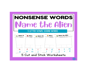
3 Letter Nonsense Words Name the Alien
ELA, Language Development, Phonics, Reading, Preschool, Grade 1, Activities
Learning to decode new words is an essential reading skill, and these Nonsense Words worksheets make mastering vowel sounds fun! This pack contains 6 alien-themed worksheets focused on creating and sounding out nonsense words to build phonics skills. Each page contains a blank box for children to design, draw and color their own alien. They then have a collection of sounds at the bottom to cut out and create a nonsense name for their alien that includes a specific vowel sound that will go in the middle of the silly alien name. Students will practice isolating and pronouncing the target sounds as they figure out how to read the funny names. With fun graphics and engaging activities, these Nonsense Word worksheets provide enjoyable phonics practice. Children will get repeated exposure to the basic short vowel sounds that pop up frequently in English words. The alien theme adds an element of entertainment to help hold kids' interest as they tackle each new sound challenge. Educators looking for a supplemental resource to help students master short vowel sounds will love this pack. It provides focused practice to cement knowledge of these fundamental phonics skills in a refreshing way! The eye catching clipart is courtesy of Kari Bolt Clipart
Author SEN Resource Source
Tags Word Blending, Decoding Practice, Early Reading Skills, Reading Fluency , Phonological Awareness, Short Vowel Sounds, Nonsense Words, Alien Words, Phonic, Reading

Split Digraphs Nonsense Words Name the Alien
ELA, Language Development, Phonics, Reading, Preschool, Grade 1, Activities
Learning to decode new words is an essential reading skill, and these Nonsense Words worksheets make mastering vowel sounds fun! This pack contains 5 alien-themed worksheets focused on creating and sounding out nonsense words to build phonics skills. Each page contains a blank box for children to design, draw and color their own alien. They then have a collection of sounds at the bottom to cut out and create a nonsense name for their alien that includes a specific split digraph sound already set as part of the silly alien name. Students will practice isolating and pronouncing the target sounds as they figure out how to read the funny names. With fun graphics and engaging activities, these Nonsense Word worksheets provide enjoyable phonics practice. Children will get repeated exposure to the split digraphs that pop up frequently in English words. The alien theme adds an element of entertainment to help hold kids' interest as they tackle each new sound challenge. Educators looking for a supplemental resource to help students master split digraphs will love this pack. It provides focused practice to cement knowledge of these fundamental phonics skills in a refreshing way! The eye catching clipart is courtesy of Kari Bolt Clipart
Author SEN Resource Source
Tags Phonics, Split Digraphs, Reading, Nonsense Words, Phonological Knowledge, Alien Words

ESL Reading Comprehension + Writing Worksheet - Virtual Reality
ELA, Language Development, ESL, Writing, Reading, Reading Comprehension, Grade 7, 8, 9, 10, 11, 12, Worksheets & Printables, Worksheets
ESL Reading Comprehension + Writing Worksheet - Virtual Reality This Fantastic ESL-EFL-TESOL Reading Comprehension + Writing Activity Worksheet on Virtual Reality and its uses (3 PDF Printable Slides) is great to train Language skills in English. Ideal participants for this ESL Activity are English Foreign Students at High School (7th-12th Grade). Newcomers or any English Language Learner can be more than suitable for this ESL EFL TESOL Activity! This Product can also be Great for ESL Centers Abroad or any English second language tutor. This ESL Reading Comprehension Activity (Worksheet; 3 PDF Printable slides) can be great for intermediate-advanced English as a Second Language Learners. This Stimulating and Amazing ESL Reading Comprehension Activity Worksheet on Virtual Reality (3 Slides; PDF Printable Teaching Resource) includes: a text on "Virtual Reality and its uses" (Artificial Intelligence-generated text with prompts from magazines such as the National Geographic + Forbes; edited by me) 11 Text-related Questions (with space for answers) 1 Essay Prompt (Writing about potential pros and cons of Immersive technologies; how can our lives improve, what job places can be creates and which ones will require less employment etc.) This ESL, EFL, TESOL, TEFL PDF Teaching Resource (Worksheet Reading Comprehension Activity 3 Printable Slides) can be great for Intermediate Advanced English as a second or foreign language learners. Its aim is to make students exercise and/or improve their Reading Comprehesion and Writing English as a second language Skills. ESL with Alan is a Brand New ESL, EFL, TESOL Store whose aim is to help English as a Second or foreign Language Teachers, Educators and Tutors (be it online or offline) to achieve their teaching objectives while creating a fun and stimulating environment. Never Forget! Learning is fun, So should English! Always If you want to browse more of my PDF ESL, EFL, TESOL Teaching Resources, click here Learning with Alan!
Author Learning with Alan
Tags Reading, Worksheet, Virtual Reality, Technology, ESL, English As A Second Language, Printable, Reading Comprehension, Writing, Essay
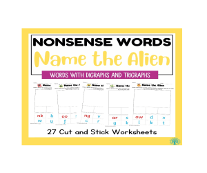
Digraph and Trigraph Nonsense Words Name the Alien
ELA, Language Development, Phonics, Reading, Preschool, Grade 1, Activities
Learning to decode new words is an essential reading skill, and these Nonsense Words worksheets make mastering digraphs and trigraphs fun! This pack contains 27 alien-themed worksheets focused on creating and sounding out nonsense words to build phonics skills. Each page contains a blank box for children to design, draw and color their own alien. They then have a collection of sounds at the bottom to cut out and create a nonsense name for their alien that includes a specific digraph or trigraph. These letter combinations included areck, nk, ng, sh, th, ch, ay, ee, ow, oo, ar, or, ir, ou, oy, oa, ur, aw, er, ea, oi, ai, ew, igh, are, ear which can appear in the beginning, middle or end of the silly alien names. Students will practice isolating and pronouncing the target sounds as they figure out how to read the funny names. With fun graphics and engaging activities, these Nonsense Word worksheets provide enjoyable phonics practice. Children will get repeated exposure to the major digraphs and trigraphs that pop up frequently in English words. The alien theme adds an element of entertainment to help hold kids' interest as they tackle each new sound challenge. Educators looking for a supplemental resource to help students master digraphs and trigraphs will love this pack. It provides focused practice to cement knowledge of these fundamental phonics skills in a refreshing way!
Author SEN Resource Source
Tags Phonics, Nonsense Words, Digraphs, Trigrpahs, Literacy Skills, Word Blending, Decoding Practice, Early Reading Skills, Reading Fluency, Phonological Awareness
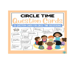
Circle Time Question Cards
Special Resources, Social Emotional Learning (SEL), Social Skills, Not Grade Specific, Centers, Activities
Introducing our Circle Time Question Cards, a valuable educational resource designed to foster meaningful conversations and enhance communication skills among children. This set of 56 thoughtfully crafted question cards serves as an engaging tool for educators, parents, and caregivers alike. Each card features a unique question, carefully selected to spark curiosity, encourage self-expression, and promote active participation during circle time. From thought-provoking inquiries that inspire creative thinking to prompts that facilitate social interaction, these cards cover a diverse range of topics to suit various age groups and developmental stages. Created with the aim of nurturing a positive and inclusive learning environment, these Circle Time Question Cards are more than just a teaching aid; they are a catalyst for building strong interpersonal connections. By prompting children to share their thoughts, experiences, and perspectives, the cards contribute to the development of essential communication skills, empathy, and self-confidence. The simplicity and versatility of this resource make it suitable for various educational settings, including classrooms, homeschooling environments, and after-school programs. Whether you're an educator looking to enrich your lesson plans or a parent eager to facilitate engaging conversations at home, these Circle Time Question Cards provide a valuable and enjoyable means to promote meaningful dialogue and foster a sense of community among children. Elevate your teaching experience with this versatile tool that goes beyond instruction, cultivating a space where young minds can flourish through the power of conversation.
Author SEN Resource Source
Tags Conversation Starters, Dialogue Prompts, Social Skills Development, Group Discussions, Classroom Engagement, Thought-provoking Questions, Circle Time, Active Participation, Social Interaction
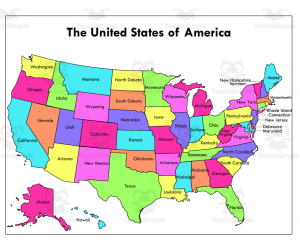
The United States of America Map Labeled
Social Studies, History, History: USA, Geography, Not Grade Specific, Worksheets & Printables, Worksheets
The United States Map Labeled provides a visual overview of the country's geographical layout. This teaching resource suits various instructional contexts. The full-color version bursts with vivid hues, enabling students to easily identify each state's location, capital, and unique attributes. Its brightness makes it an ideal tool for teaching geography. Alternatively, the black and white adaptation allows for diverse applications like map coloring exercises or professional reports requiring formality. Both versions serve indispensable purposes: the colored version offers immediate understanding while the monochromatic version provides versatility. Teachers can utilize these maps to plan engaging activities. Students gain familiarity with states' borders, neighboring regions, distribution of congressional districts, and more. Whether adding liveliness to a lesson or serving formal presentations, this dual map set caters to diverse needs across education, business , travel, and government.
Author educ_project
Tags USA MAP, Color Map, Social Studies, United States, Map
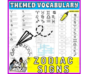
Vocabulary with Cards | Crossword Wordsearch Anagram ZODIAC SIGNS
Special Resources, ELA, Special Education Needs (SEN), Speech Therapy, Life Skills, Language Development, ESL, Writing, Handwriting, Spelling, Vocabulary, Not Grade Specific, Crosswords Puzzles, Worksheets, Worksheets & Printables
Word Games with Puzzles | Crossword Wordsearch Anagram | ZODIAC SIGNS . A resource designed especially for educators who value enhancing language skills in inventive ways . This pack provides a diverse set of word games and puzzles, all centered on the theme of ZODIAC SIGNS . Created to engage students meaningfully and rectify their knowledge about commonly used ZODIAC SIGNS-related words . Educators are provided with several varied activities: anagrams, copy words crossword, a blank writing board, lined writing board, word matching page, wheel chart and word search board . The chosen vocabulary words cater to useful ZODIAC SIGNS-related phrases, thus creating context-based learning . Versatility of the Resource . This versatile resource can be used in multiple ways . Kickstart the day with these activities as part of morning work routine or incorporate into teaching centers for active learning participation . Also use them as handouts or even as fun homework assignments which students would love to participate in! Beyond Classroom Applications . The application isn't just confined to the classroom alone; they are adaptable enough for therapy sessions too! Whether you are working on language development exercises like vocabulary enhancement or conversation prompts in group settings - these worksheets provide varied options that serve different purposes . You Receive : An easy-to-use package - an 20 pages pdf file combining worksheets and images ready for immediate use after printing! A non-grade specific resource- adaptable enough to be used by different grade levels conveniently! Note : These games not only concentrate on mastering language arts but also aid learners in understanding scientific and community concepts while assisting develop cognitive skills simultaneously! Conclusion : Enrich your teaching environment with this multi-faceted tool that aims not just at direct instruction but skill-building across various domains – a crucial aspect towards accomplishing holistic education! Included: 20 page PDF with word games worksheets and flash cards .
Author WORDS ASIDE
Tags Flash Cards, Esl, Thematic Vocabulary, Word Wall, Independent Work, Centers, Writing Expository, Community, Words Aside, Zodiac Signs

Vocabulary with Cards | Crossword Wordsearch Anagram YOGA PILATES
Special Resources, ELA, P.E. & Health, Special Education Needs (SEN), Speech Therapy, Life Skills, Language Development, ESL, Writing, Handwriting, Spelling, Vocabulary, Health, Yoga, Not Grade Specific, Crosswords Puzzles, Worksheets, Worksheets & Printables
Word Games with Puzzles | Crossword Wordsearch Anagram | YOGA PILATES . A resource designed especially for educators who value enhancing language skills in inventive ways . This pack provides a diverse set of word games and puzzles, all centered on the theme of YOGA PILATES . Created to engage students meaningfully and rectify their knowledge about commonly used YOGA PILATES-related words . Educators are provided with several varied activities: anagrams, copy words crossword, a blank writing board, lined writing board, word matching page, wheel chart and word search board . The chosen vocabulary words cater to useful YOGA PILATES-related phrases, thus creating context-based learning . Versatility of the Resource . This versatile resource can be used in multiple ways . Kickstart the day with these activities as part of morning work routine or incorporate into teaching centers for active learning participation . Also use them as handouts or even as fun homework assignments which students would love to participate in! Beyond Classroom Applications . The application isn't just confined to the classroom alone; they are adaptable enough for therapy sessions too! Whether you are working on language development exercises like vocabulary enhancement or conversation prompts in group settings - these worksheets provide varied options that serve different purposes . You Receive : An easy-to-use package - an 24 pages pdf file combining worksheets and images ready for immediate use after printing! A non-grade specific resource- adaptable enough to be used by different grade levels conveniently! Note : These games not only concentrate on mastering language arts but also aid learners in understanding scientific and community concepts while assisting develop cognitive skills simultaneously! Conclusion : Enrich your teaching environment with this multi-faceted tool that aims not just at direct instruction but skill-building across various domains – a crucial aspect towards accomplishing holistic education! Included: 24 page PDF with word games worksheets and flash cards .
Author WORDS ASIDE
Tags Flash Cards, Esl, Thematic Vocabulary, Word Wall, Independent Work, Centers, Writing Expository, Community, Words Aside, Pilates

Holes Vocabulary Slides
ELA, Reading, Library, Grade 5, 6, 7, Presentations, Teacher Tools
Enhance Literary Vocabulary with "Holes" Novel Vocabulary Slides - 26 PDF Slides for Educators Introducing a powerful teaching resource designed to enrich your students' language skills and comprehension of the beloved novel, "Holes" by Louis Sachar. Our meticulously crafted collection of 26 Vocabulary Slides in convenient PDF format brings the captivating world of "Holes" to life while promoting vocabulary acquisition and language fluency. Key Features: 1. Comprehensive Vocabulary Coverage: Our "Holes" Vocabulary Slides encompass a diverse range of carefully selected words from the novel, spanning different chapters and scenes. Each slide highlights a vocabulary word, its part of speech, and a clear, concise definition to aid your students' understanding. 2. Engaging and Visual: Foster an interactive learning environment with visually appealing slides that captivate your students' attention. Each slide is thoughtfully designed to resonate with the novel's themes and aesthetics. 3. Aligned with Academic Standards: Our "Holes" Vocabulary Slides align seamlessly with language arts and literature curriculum guidelines. Help your students meet learning objectives while exploring the rich language of the novel. 4. User-Friendly PDF Format: Easily accessible and printable, these PDF slides are ideal for in-person and virtual classrooms alike. Share them with your students digitally or print them as handouts to facilitate engaging group discussions and independent study. - Novel Vocabulary - Literary Language Skills - Language Fluency - Educational Resources - Vocabulary Acquisition - Language Arts Curriculum - Teacher's Toolkit - Interactive Learning - Classroom Engagement - Literature Comprehension Why Choose Our "Holes" Vocabulary Slides: - Comprehensive Approach: Our collection covers a broad spectrum of words from "Holes," allowing you to dive deep into the novel's language intricacies. - Time-Saving: Eliminate the need to manually curate vocabulary lists. Our slides are ready to use, saving you valuable preparation time. - Student-Centric: Foster a love for reading and language exploration among your students with engaging vocabulary exposure tied to a compelling narrative. - Flexible Usage: Suitable for middle and high school grade levels, these slides can be adapted to fit various teaching styles and settings. Elevate your literature instruction with our "Holes" Vocabulary Slides. Equip your students with the language skills they need to fully appreciate the novel's depth and complexity. Order now and embark on a journey of literary exploration! Note: This product is not affiliated with or endorsed by the author or publisher of "Holes" by Louis Sachar.
Author Simply Third and Thriving
Tags Holes, Vocabulary Slides

Atomic Theory and Structure Overview - Senior Chemistry lesson
Science, Chemistry, Grade 10, 11, 12, Teacher Tools, Lesson Plans
Atomic Theory and Structure Overview - Senior Chemistry Lesson Your lesson covers atomic theory and structure. In order, the lesson teaches about; Organizing Matter, Relative Masses, Atomic History and Theory, The Modern Periodic Table, Structure of an Atom, Ions, Atomic Mass, and Isotopes. Your lesson includes the teacher and student version of the presentation, TWO embedded videos, an auto-graded exit ticket, and a student lesson handout so the students can record the notes on a more condensed medium. This lesson is designed to be your go-to resource, whether you're in a traditional classroom or a virtual one. With both a teacher version and a student version, it seamlessly fits into your lesson plans, making learning engaging and adaptable. Assessment made easy We've included an auto-graded Exit Ticket and a quiz with an answer key because I know you don't have an excess of time. I know you don't, because I don't and I know I'll do whatever I can to reduce my grading time. Whether you use PowerPoint or Google Slides, prefer Word or Google Docs, this lesson has you covered. This lesson comes in both Office and Google formats for your convenience. The student version of the presentation has strategically placed blanks for them to fill in as you're teaching. It keeps them active and engaged, encourages discussion, and leaves more time for those "aha" moments.
Author Teach With Fergy
Tags Chemistry Lesson, Matter, Relative Mass, Atomic History, Atomic Theory, Periodic Table, Ions, Atomic Mass, Isotopes

Preparing Solutions and Dilutions - Senior Chemistry lesson
Science, Chemistry, Grade 10, 11, 12, Teacher Tools, Lesson Plans
Preparing Solutions and Dilutions - Senior Chemistry Lesson Your lesson covers solutions and dilutions and how to prepare them. In order, the lesson includes; Preparing Solutions, Solutions Mini Lab, Dilutions, Practice Questions with Walkthrough Answers, and a Dilutions Mini Lab. Your lesson includes the teacher and student version of the presentation, an auto-graded exit ticket, and a student lesson handout so the students can record the notes on a more condensed medium. This lesson is designed to be your go-to resource, whether you're in a traditional classroom or a virtual one. With both a teacher version and a student version, it seamlessly fits into your lesson plans, making learning engaging and adaptable. Assessment made easy We've included an auto-graded Exit Ticket and a quiz with an answer key because I know you don't have an excess of time. I know you don't, because I don't and I know I'll do whatever I can to reduce my grading time. Whether you use PowerPoint or Google Slides, prefer Word or Google Docs, this lesson has you covered. This lesson comes in both Office and Google formats for your convenience. The student version of the presentation has strategically placed blanks for them to fill in as you're teaching. It keeps them active and engaged, encourages discussion, and leaves more time for those "aha" moments.
Author Teach With Fergy
Tags Chemistry Lesson, Solutions, Preparing Solutions, Preparing Dilutions, Dilutions