The United States of America Map Labeled


Attributes
Grades
File
Editable
No
Rating
Add To Collection
About This Product
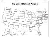
The United States Map Labeled provides a visual overview of the country's geographical layout. This teaching resource suits various instructional contexts. The full-color version bursts with vivid hues, enabling students to easily identify each state's location, capital, and unique attributes. Its brightness makes it an ideal tool for teaching geography. Alternatively, the black and white adaptation allows for diverse applications like map coloring exercises or professional reports requiring formality. Both versions serve indispensable purposes: the colored version offers immediate understanding while the monochromatic version provides versatility. Teachers can utilize these maps to plan engaging activities. Students gain familiarity with states' borders, neighboring regions, distribution of congressional districts, and more. Whether adding liveliness to a lesson or serving formal presentations, this dual map set caters to diverse needs across education, business, travel, and government.
Resource Tags
0 Reviews
Explore related searches
you may also like...
Check out these other great products

Teacher Tools, Graphic Organizers
Worksheets & Printables, Writing Prompts, Worksheets

Worksheets & Printables, Worksheets

Teacher Tools, Presentations

Worksheets & Printables, Worksheets