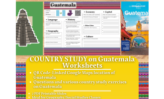
Country Study Presentation - Guatemala - Central America - Geography


About This Product
Country Study Presentation - Guatemala - Central America - Geography
Try this Digital Teaching Resource on Guatemala (Introductory Presentation Lesson), designed for Geography, Central American History (Hispanic and Latino Studies), and Social Studies lessons. Perfect for Grades 7–12 (Middle school and High School students), this Introductory PDF Presentation offers a fun, informative, and ready-to-use lesson that requires little to no preparation.
Students will explore Guatemala’s geography, history, culture, language and economy — making it perfect for classroom instruction, homeschooling, or online learning.
📘 Within this Social Studies and Geograhy Teaching resource, teachers and educators can find the following topics dealt:
✅ Greetings in Spanish
✅ Geography of Guatemala (Hispanic and Latino Studies) – Key facts, borders, and an interactive Google Maps link to its location.
✅ Quick Facts – Population, capital city, currency, flag, and other essential details.
✅ History Overview – A concise summary of Guatemala’s most significant historical events.(Hispanic and Latino Studies)
✅ Geography & Environment – Details about the country’s land area, regions, and climate zones.
✅ El Salvador's Economy – Insight into Guatemala’s industries, exports, and economic strengths. (Hispanic and Latino Studies)
✅ Guatemala City – Explore the capital city, its famous landmarks, and cultural highlights.
✅ Other Major Cities – A map showcasing additional important urban centers.
✅ Guatemala's Culture & Traditions – A look at the customs and values that define Guatemala (Hispanic and Latino Studies)
✅ Farewell in Spanish
🎯 Perfect For:
Geography classes
Social Studies
World cultures units
Country study projects
Substitute teacher lessons
Digital learning
In-class or online teaching
📂 Resource Details
Format: PDF Digital Presentation
Grade Levels: 7th–12th Grade (Middle School & High School)
Prep Time: Low to no preparation required
If you want to browse more of my Teaching Resources, click here Learning with Alan!
Resource Tags
0 Reviews
Check out these other great products