


Map Scales Worksheet
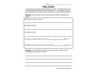
Map scale lesson page that explains graphic scales, then has students measure between two points on a real road map with a ruler and convert the distance.

- Grades
- Grades 4–6, Elementary, Middle School
- File type
- Preparation
- Print ready


- Subject
- Social Studies, Geography
- Topic
- Maps
- Resource types
- Worksheets & Printables, Worksheets
- Preparation
- Print ready
About this resource
What's inside this resource
This Map Scales Worksheet is a great way for students to learn how to use a map scale to find locations on a map. This is a skill that is essential for any student interested in geography or map skills.
Related resources
More resources teachers may find useful
24 related resources were found using this product's title, contributor, categories and tags.


In the classroom
Teaching tips & learning objectives

Learning objectives
- Measure a distance on a map and convert it using the scale
- Explain why scales differ between maps

Teaching tips
- Students need a real road map and a ruler; having maps with different scales on hand gives them something concrete for the closing question.

Skills covered
- Measuring — finding the real distance between two chosen points on a road map

No reviews yet
Downloaded this resource? Tell other teachers how it went.
Resource details
Concepts & topics
Core concepts
 Core concepts
- Map scale
- Graphic scale
- Distance
Topics
 Topics
Explore more
Categories this resource belongs to
Explore related searches
More to explore
You may also like

Worksheets & Printables, Worksheets


Worksheets & Printables, Worksheets

Worksheets & Printables, Worksheets

Worksheets & Printables, Worksheets
Worksheets & Printables, Worksheets

Worksheets & Printables, Worksheets